Difference between revisions of "Punjab"
Jump to navigation
Jump to search
(image, states) |
(→In Pakistan) |
||
| Line 56: | Line 56: | ||
* [[Campbellpur District]] (now [[Attock District]]) | * [[Campbellpur District]] (now [[Attock District]]) | ||
* [[Chenab Colony]] | * [[Chenab Colony]] | ||
| + | * [[Dera Ghazi Khan District]] | ||
* [[Gujranwala District]] | * [[Gujranwala District]] | ||
| + | * [[Jhang District]] | ||
* [[Jhelum District]] | * [[Jhelum District]] | ||
* [[Lahore District]] | * [[Lahore District]] | ||
| + | * [[Mianwali District]] | ||
* [[Montgomery District]] (now Sahiwal District) | * [[Montgomery District]] (now Sahiwal District) | ||
* [[Multan District]] | * [[Multan District]] | ||
| + | * [[Muzaffargarh District]] | ||
* [[Shahpur District]] | * [[Shahpur District]] | ||
* [[Sheikhupura District]] | * [[Sheikhupura District]] | ||
* [[Sialkot District]] | * [[Sialkot District]] | ||
| − | |||
== External Links == | == External Links == | ||
Revision as of 14:35, 1 November 2009
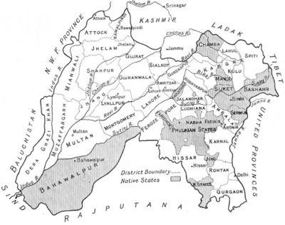
Punjab was a British province between 1849 and 1947 that was part of the Bengal Presidency. The Punjab region covers the area of the two modern states of the same name (one on each side of the India-Pakistan border).
Contents
History
The entire province became part of British India in 1849 after the 2nd Sikh War. Punjab was partitioned between India and Pakistan in 1947.
Capital
Cities and Towns
In India
In Pakistan
- Attock
- Dera Ghazi Khan
- Fort Munro
- Gujerat (now spelt Gujrat)
- Jhelum
- Khewra
- Lahore
- Lyallpur (now Faisalabad)
- Montgomery (now Sahiwal)
- Multan
- Murree
- Rawalpindi
- Pind Dadan Khan
- Sialkot
Princely States
India
Pakistan
Districts and Other Areas
In India
In Pakistan
- Campbellpur District (now Attock District)
- Chenab Colony
- Dera Ghazi Khan District
- Gujranwala District
- Jhang District
- Jhelum District
- Lahore District
- Mianwali District
- Montgomery District (now Sahiwal District)
- Multan District
- Muzaffargarh District
- Shahpur District
- Sheikhupura District
- Sialkot District
External Links
Wikipedia:
Historical online books:
- "Life in the Punjab" Calcutta Review Volume 26, January-June 1856 (Google Books)
