Kurseong: Difference between revisions
Jump to navigation
Jump to search
new page |
Symorsebrown (talk | contribs) Add coordinates |
||
| Line 2: | Line 2: | ||
|presidency= [[Bengal (Presidency)|Bengal]] | |presidency= [[Bengal (Presidency)|Bengal]] | ||
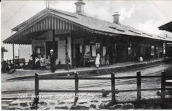
|image= Kurseong Station BN Rly.jpg | |image= Kurseong Station BN Rly.jpg | ||
|coordinates | |coordinates= [http://maps.google.co.uk/maps?ll=26.88,88.288&z=13&t=h&hl=en 26.88°N 88.288°E] | ||
|altitude= 1,500 | |altitude= 1,500 metres (4,900 ft) | ||
|presentname= [http://en.wikipedia.org/wiki/Kurseong Kurseong] | |presentname= [http://en.wikipedia.org/wiki/Kurseong Kurseong] | ||
|stateprovince= [http://en.wikipedia.org/wiki/West_Bengal Bengal] | |stateprovince= [http://en.wikipedia.org/wiki/West_Bengal Bengal] | ||
Revision as of 18:47, 7 February 2012
| Kurseong | |
|---|---|

| |
| Presidency: Bengal | |
| Coordinates: | 26.88°N 88.288°E |
| Altitude: | 1,500 metres (4,900 ft) |
| Present Day Details | |
| Place Name: | Kurseong |
| State/Province: | Bengal |
| Country: | India |
| Transport links | |
| Darjeeling-Himalayan Railway | |