Girgaon: Difference between revisions
Jump to navigation
Jump to search
No edit summary |
Symorsebrown (talk | contribs) Edit info box. spelling, widget, category |
||
| Line 2: | Line 2: | ||
|presidency= [[Bombay (Presidency)|Bombay]] | |presidency= [[Bombay (Presidency)|Bombay]] | ||
|image= | |image= | ||
|coordinates= [https://www.google.com/maps/search/18.953,72.813/@18.953,72.813,12z/data=!4m2!2m1!4b1?hl=en | |coordinates= [https://www.google.com/maps/search/18.953,72.813/@18.953,72.813,12z/data=!4m2!2m1!4b1?hl=en 18.953°N 72.813°E] | ||
|altitude= 12 m (39 ft) | |altitude= 12 m (39 ft) | ||
|presentname= [https://en.wikipedia.org/wiki/Girgaon Girgaon] | |presentname= [https://en.wikipedia.org/wiki/Girgaon Girgaon] | ||
|stateprovince= [https://en.wikipedia.org/wiki/Maharashtra Maharashtra] | |stateprovince= [https://en.wikipedia.org/wiki/Maharashtra Maharashtra] | ||
|country= India | |country= [http://en.wikipedia.org/wiki/India India] | ||
|transport= | |transport= | ||
}} | }} | ||
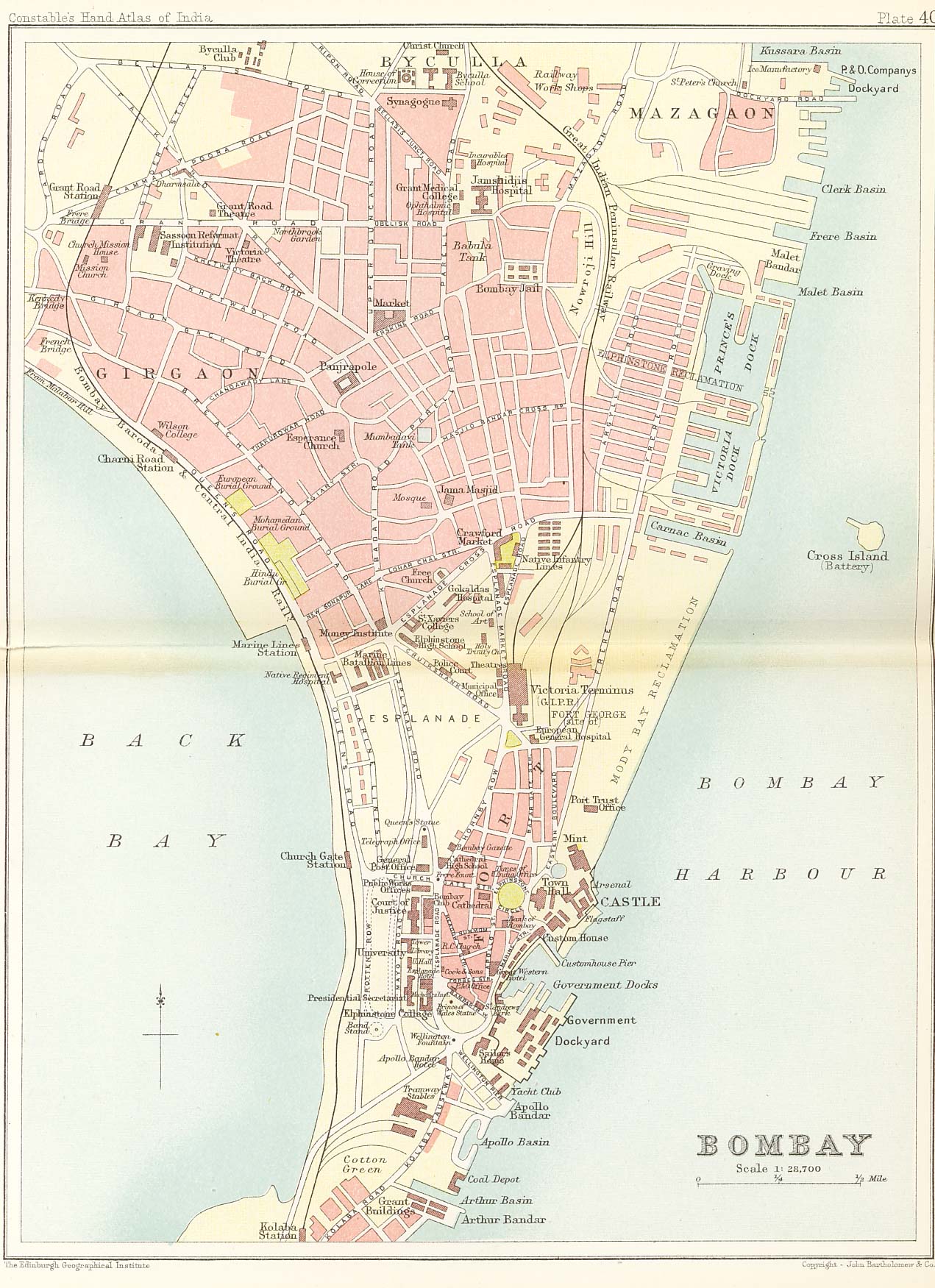
'''Girgaon''' is an area in the southern part of [[Bombay (City)|Bombay City]]. | '''Girgaon''' is an area in the southern part of [[Bombay (City)|Bombay City]]. | ||
Note: there was also a Girgaon located near [[Gwalior|Morar, Gwalior]] <ref>[https://books.google.com.au/books?id=WZdeAAAAcAAJ&pg=PA127 Page 127] ''The Second and Third Sections of the Report of the Commissioners Appointed to Inquire Into the Cholera Epidemic of 1861 in Northern India'' 1864 Google Books</ref> | |||
==Spelling variants== | ==Spelling variants== | ||
Girgaon | modern name: Girgaon<br> | ||
Variants: Girgaum/Girigaum | |||
==External links== | ==External links== | ||
*[https://en.wikipedia.org/wiki/Girgaon Girgaon] Wikipedia | *[https://en.wikipedia.org/wiki/Girgaon Girgaon] Wikipedia (retrieved 13 May 2016) | ||
*[http://homepages.rootsweb.com/~poyntz/India/images/Bombay1893.jpg 1893 Map of Bombay showing Girgaon] (top left). Ian Poyntz's "Historical Maps of India" | *[http://homepages.rootsweb.com/~poyntz/India/images/Bombay1893.jpg 1893 Map of Bombay showing Girgaon] (top left). Ian Poyntz's "Historical Maps of India" | ||
| Line 24: | Line 24: | ||
<references /> | <references /> | ||
{{#widget:Google PlusOne | |||
|size=small | |||
|count=true | |||
}} | |||
[[Category:Locations]] | [[Category:Locations]] | ||
[[Category:Bombay]] | [[Category:Cities, towns and villages in Bombay Presidency]] | ||
Revision as of 16:01, 13 May 2016
| Girgaon | |
|---|---|
| [[Image:|250px| ]] | |
| Presidency: Bombay | |
| Coordinates: | 18.953°N 72.813°E |
| Altitude: | 12 m (39 ft) |
| Present Day Details | |
| Place Name: | Girgaon |
| State/Province: | Maharashtra |
| Country: | India |
| Transport links | |
Girgaon is an area in the southern part of Bombay City. Note: there was also a Girgaon located near Morar, Gwalior [1]
Spelling variants
modern name: Girgaon
Variants: Girgaum/Girigaum
External links
- Girgaon Wikipedia (retrieved 13 May 2016)
- 1893 Map of Bombay showing Girgaon (top left). Ian Poyntz's "Historical Maps of India"
References