Bangalore
| Bangalore | |
|---|---|

| |
| Presidency: Madras | |
| Coordinates: | 12.966667°N, 77.566667°E |
| Altitude: | 920 m (3,018 ft) |
| Present Day Details | |
| Place Name: | Bengaluru |
| State/Province: | Karnataka |
| Country: | India |
| Transport links | |
| Chikballapur-Bangalore City Railway Madras Railway Mysore State Railway Southern Mahratta Railway | |
| FibiWiki Maps | |
|---|---|
| See our interactive map of this location showing places of interest during the British period | |
| Bangalore |
Bangalore (now Bengaluru) became part of British India in 1809. It was the scene of a mutiny in 1832, which was unsuccessful. Bangalore is the capital of the modern Indian state of Karnataka.
Contents
Military history
Military
Battle of Bangalore 1791
Bangalore Mutiny 1832
Gallery
See also Images of Bangalore
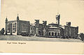
Royal Palace 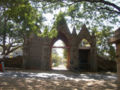
Hosur Road Cemetery 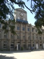
Baldwins Methodist College 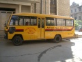
Baldwins Boys High School bus


Cemeteries
- Bangalore Cemeteries
- Agram Cemetery, Gravestone Inscriptions 1806-1866 (Old Protestant Cemetery)
FIBIS resources
Churches
- St John's Church, 132 St John's Church Road
- St Patrick's Cathedral, Brigade Road
- St Mark's Cathedral Church, MG Road
Schools
- Joseph's College, Lalbagh Road
- Baldwins Boys High School, Hosur Road
Palaces
- Bangalore Royal Palace, Jayamahal Road
External links
- Churches of Bangalore Bangalorebest.com
- Bangalore Love to Know 1911
- Bangalore Wikipedia
- Bangalore map 1924 Wikipedia
- Ronnie Johnson's Bangalore site - covers many topics including cemeteries, churches, streets and houses, schools and more
- Whitefield, Bangalore established 1882 livemint.com Friday, 14 October 2011
Historical books online
- Bangalore Imperial Gazetteer of India Volume 6, page 368.
- "Map of Bangalore", between pages 388 and 389, A Handbook for Travellers in India, Burma, and Ceylon published by John Murray, London Eighth Edition 1911 Archive.org.
- Bangalore page 67, The Edinburgh Medical and Surgical Journal Volume 68 1847. The cantonment was classified as one of the "Stations on the Table Lands"
- Personal collection of over 100 photos of Bangalore taken between 190-1925www.sharehistory.org