Bangalore
Jump to navigation
Jump to search
| Bangalore | |
|---|---|

| |
| Presidency: Madras | |
| Coordinates: | 12.966667°N, 77.566667°E |
| Altitude: | 920 m (3,018 ft) |
| Present Day Details | |
| Place Name: | Bengaluru |
| State/Province: | Karnataka |
| Country: | India |
| Transport links | |
| Chikballapur-Bangalore City Railway Madras Railway Mysore State Railway Southern Mahratta Railway | |
| ' | |
|---|---|

| |
| See our interactive map of Bangalore on Google Maps | |
Bangalore (now Bengaluru) became part of British India in 1809. It was the scene of a mutiny in 1832, which was unsuccessful. Bangalore is the capital of the modern Indian state of Karnataka.
Contents
History
Battle of Bangalore 1791
Bangalore Mutiny 1832
FIBIS resources
Related articles
Gallery
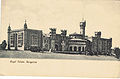
Royal Palace, Bangalore 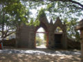
Hosur Road Cemetery, Bangalore


Interactive Map
<googlemap version="0.9" lat="13.005896" lon="77.595062" zoom="10" controls="small"> 12.95495,77.604772, Protestant cemetery 12.991793,77.612722, St John's Church </googlemap>
External links
- Churches of Bangalore Bangalorebest.com
- Bangalore Love to Know 1911
- Bangalore Wikipedia
- Bangalore map 1924 Wikipedia
- Ronnie Johnson's Bangalore site - covers many topics including cemeteries, churches, streets and houses, schools and more