Difference between revisions of "Belgaum"
Jump to navigation
Jump to search
Symorsebrown (talk | contribs) (Add spelling) |
(Image Added) |
||
| Line 19: | Line 19: | ||
[[Siege of Belgaum]] 1818 | [[Siege of Belgaum]] 1818 | ||
| + | ==Churches== | ||
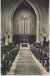
| + | [[Image:St Mary's Church, Belgaum.jpg|left|thumb|100px|''Interior St Mary's Church, Belgaum'']] | ||
[[Category:Locations]] | [[Category:Locations]] | ||
Revision as of 07:20, 22 April 2011
| Belgaum | |
|---|---|
| [[Image:|250px| ]] | |
| Presidency: Madras | |
| Coordinates: | 15.850362°N 74.504672°E |
| Altitude: | 762 m (2,500 ft) |
| Present Day Details | |
| Place Name: | Belgaum Belgaum |
| State/Province: | Karnataka |
| Country: | India |
| Transport links | |
| Southern Mahratta Railway | |
Belgaum, a town and district of British India, in the southern division of Bombay. The town is situated 245 miles south of Poona; it has a station on the Southern Mahratta railway.
Spelling variants
Modern name: Belgaum
Variants: Belgaon
History
Siege of Belgaum 1818
