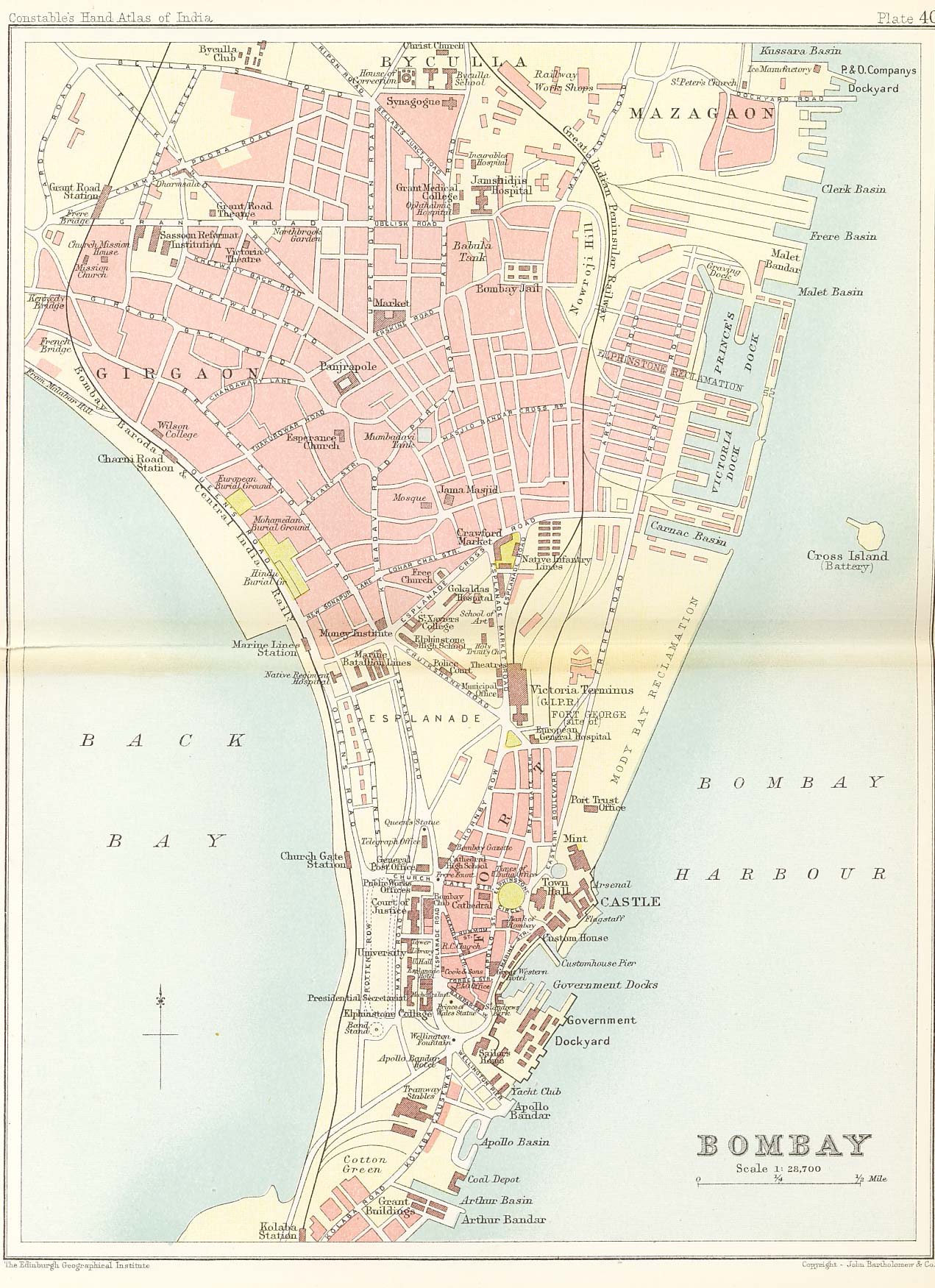
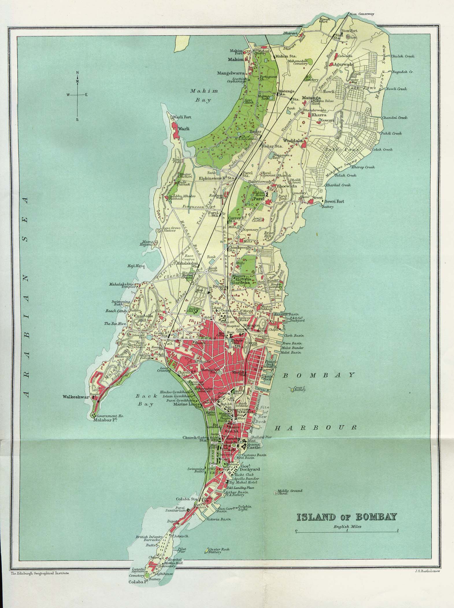
Bombay (City)
| Bombay (City) | |
|---|---|

| |
| Presidency: Bombay | |
| Coordinates: | 19.017656°N, 72.85618°E |
| Altitude: | 8 m (26 ft) |
| Present Day Details | |
| Place Name: | Mumbai |
| State/Province: | Maharashtra |
| Country: | India |
| Transport links | |
| Bombay, Baroda and Central India Railway Great Indian Peninsula Railway Bombay Port Trust Railway See page Bombay Railways & Stations for details | |
| FibiWiki Maps | |
|---|---|
| See our interactive map of this location showing places of interest during the British period | |
| Bombay (City) |
Bombay was the capital of the Bombay Presidency and the headquarters of the district of the same name during the British period. Now called Mumbai, it is the capital of the state of Maharashtra.
Contents
Geography
Originally there were Seven Islands of Bombay:
They were gradually merged by land reclamation until they were one land mass by 1845.
History
Located on the inlet of Bom Bahia (beautiful bay), the city was Portuguese controlled from 1534. It passed to British rule in 1661 when it was received by Charles II as part of his marriage dowry from his Portuguese wife, Catherine of Braganza. During this time there were three Royal Governors. In 1668 it was granted to the East India Company for a lease of ten pounds a year and was administered by Company Governors. These became Crown Governors when rule was transferred to the UK government. Until the 18th century, Bombay consisted of seven islands. The islands were merged to form the present day location of the city.
Compared to the other Presidencies, Bombay was of minor significance before 1800. The English were very much the minority. Recognising this, a liberal attitude encouraged progressive Indian cotton merchants, this freedom resulted in Bombay's economic importance. It was the cotton industry that spurred economic migration to the city from surrounding rural areas, and saw Bombay’s population grow rapidly:
- Year Population
- 1700 10,000
- 1800 100,000
- 1900 775 000
Following the Battle of Kirkee 1817 and the defeat of the Peshwas, the Bhor Ghat road to Poona opened 1830, allowing greater access to the Deccan cotton fields. Bombay became the commercial centre of the Malwa opium trade, and opium also became the basis for the prosperity of Bombay.[1] Railways much improved goods transport, the Great Indian Peninsula Railway (GIPR)opened in 1864. This allowed Bombay to fill the global demand for cotton resulting from shortages as a consequence of the American Civil War’s blockade of its southern ports(1860-1865). The opening of the Suez Canal 1869 further shortened the passage to England. The resultant economic boom saw wealthy businessmen sponsor many civic buildings – University Library Buildings, Jamsetji Jijibhoy (JJ) School of Art, and the Mechanics Institute. From the 1860‘s many municipal improvement schemes focused on improving health and sanitation.
Because of the cosmopolitan mix of Bombay Society, it is architecturally unlike the most of colonial india's neo-classicism; the wealth citizens of Bombay, and the city's Public Works Department opted for Venetian-Gothic designs with alterations to suit the Indian Climate. Victoria Terminus the station of the GIPR, adorned with Indian motifs represents this patronage. Bombay introduced Modernist architecture to India seeing new concrete construction methods as an inclusive architecture available to India's masses in the lead up to Independence.
Bombay City Improvement Trust
The Bombay City Improvement Trust was created on December 9, 1898, in response to the Bobbay plague epidemic of 1896. It was created through an Act of the Parliament. The Municipal Corporation and the government handed over all vacant lands to this body. The Trust undertook a host of measures to improve sanitary and living conditions in the city. The planned opening up of suburbs was due to the Trust [2]
The Trust widened roads in the central, crowded, parts of the town. A new east-west road, the Princess Street, was constructed to channel the sea air into the centre of the crowded residential areas. The north-south Sydenham Road (now Mohammedali Road) was also constructed with this end in view [2].
The Dadar-Matunga-Wadala-Sion suburban development was started in 1899 with the express purpose of relieving congestion to the south. Well-laid out plots, with mixed land-use patterns marked these sections. Completed in 1900, access to these parts were through the newly completed Mohammedali Road [2].
The Trust was later merged with the Municipal Corporation and known as the Bombay Development Department/Directorate.
FIBIS Resources
- Images of Bombay in Fibiwiki
- Images of Bombay in the FIBIS Gallery
- Bombay Maps
- Bombay Golf Clubs members
Churches


Anglican
- All Saints - Malabar Hill
- Christ Church - Byculla
- St. Thomas Cathedral - the oldest Anglican church in the city, built in 1718, consecrated 1816, became the cathedral of the See of Bombay in 1833. On the south side of Church Gate Street. Originally the garrison church. See Bombay Church by Richard Cobbe for an account of the building of the English Church. There are some photographs of interest on flickr and more on Sacred Destinations website. YouTube video by indiavideo.org
- St. John the Evangelist Church, Colaba - aka the Afghan Church, consecrated 1858. Built to commemorate the dead of the 1st Afghan War. YouTube video by indiavideo.org
Presbyterian
- St Andrew's - the Scotch Kirk, Rampart Row, opened 1819. Photograph: St Andrew's Kirk by DBHKer flickr.com
Roman Catholic
Addresses of all current Catholic Churches in Mumbai (Archdiocese of Mumbai). See also Bombay in the Catholic Encyclopedia 1913.
- Cathedral of the Holy Name
- Church of the Holy Trinity
- Gloria Church - aka Nossa Senhora de Gloria, founded 1632, at Byculla
- Mount Mary Church, Bandra - aka the Basilica of Our Lady of the Mount
- Our Lady of Egypt - founded 1606
- Our Lady of Good Counsel - aka Nossa Senhora de Bom Concelho, founded 1596
- Our Lady of Health - aka Nossa Senhora de Saude, built 1794
- Our Lady of Hope - aka Nossa Senhora da Esperanca, demolished
- Our Lady of Salvation - aka Nossa Senhora de Salvação or the Portuguese Church, founded 1596, current structure is 1974
- St. Andrew's Church - built 1575
- St Michaels - founded by the Portuguese in 1534 (current building dates only to 1973)
- St Peter's, Bandra - Jesuit church. Original building 1852, current building 1938, consecrated 1964
Other
- Free Church of Scotland
- Wesleyan Methodist Church - at Colaba
- St Nicholas
- Synagogue Megan David, Byculla 1861
- Synagogue Kneseth Elijah, The Fort 1888
Cemeteries
See also List of Cemeteries
- European Burial Ground, Queens Road
- Mavgav, Byculla, the oldest cemetery (Bene-Israel)
Schools
The English established the Bombay Education Society 1815 with the primary object of educating European and Anglo-Indian children. But from the very beginning the society admitted Indian children to its schools without making religious education compulsory. In 1818 the society started English schools in Bombay city. In 1820 it established a separate committee, the Bombay Native Education Society to look after the education of Indian children
- Fort Proprietary School was opened in 1859.
- Scottish Schools (Byculla),
- Scottish Schools (Fort),
- Cathedral Choir School (Fort)
- Cathedral High Scool
- Alexandra Girls School
- Islamia School

Catholic
Boys
- The High School of St. Xavier
- St. Mary's High School
Girls
- Girls High Schools, at Clare road, Par el and the Fort.
- St. Joseph's Foundling Home
- St. Vincent's Home for poor women and girl
Orphan Schools
See Orphans-Bombay
Tertiary Education
- Elphinstone College 1835
- Grant Medical Institution 1845
- Bombay Law School
- The Government Law College, 1855
- Wilson College
- St Xavier’s College (Catholic)
- The Sydenham College
- Jamsetji Jijibhoy School of Art
- Victoria Jubilee Technical Institute
Hospitals
- European General Hospital
- Cama Hospital opened on the Esplanade in August 1886
- Bomanji Edulji Albless Obstetric Hospital in 1890
- St. George's Hospital Government (for Europeans) in December 1892
- The Gokuldas Tejpal Hospital 1868
- Acworth Leprosy Hospital , Wadala was established in 1890
- National Medical College on 4 September 1921
- Nowrosjee Wadia Maternity Hospital in 1927
- Bai Jerbai Wadia Hospital for Children in 1929
- Seth Gordhandas Sunderdas Medical College was started in June 1925,
- King Edward Memorial Hospital in February 1926
- The Nair Hospital Dental College
- The Ismail Yusuf College, established in 1929-30
Newspapers
- Bombay Chronicle, 1918-1933
- Times of India, 1873-1942
- Bombay Gazette,
- Advocate of India (Anglo-Indian)
Military

- Sion Fort
- Sion Hillock Fort Wikipedia
- HQ of Bombay Brigade in Poona Division of the Western Command
- Garrison
- 3 companies of artillery,
- 2 Native infantry,
- 5 corps volunteers: Bombay Light Horse, Bombay Volunteer Artillery, GIPR Volunteers, B,B & CIR Volunteers, Bombay Volunteer Rifles,
- Royal Indian Marines
Clubs

- The Catholic Gymkhana Club, Marine Lines
- Byculla Club, Byculla
- Yacht Club, Wellington Pier
- Bombay Club,Esplanade
- Royal Bombay Yacht Club
- Bombay Gymkhana

Growing up in Bombay
- Maxine Steller was born in 1930, daughter of Bill Taylor who was in the Bombay Police Force. The family lived in quarters behind the various police stations he was assigned to, including some very dangerous areas. She describes her early life, including becoming the female singer in a band, and the conditions before and after independence, until she left in 1950 for Australia.[3]
Also see
External links
- Bombay City Imperial Gazetteer
- Maharashtra State Gazette 1986 A modern gazette of Bombay with a comprehensive history of the city taken from many historic records and books. Detailed yet very readible and covers many subjects. Now an archived website.
- Mumbai Wikipedia.
- History of Mumbai A brief yet informative history covering key people and events during European settlement and post Independence, now an archived webpage.
- History of Mumbai Wikipedia.
- "These Mumbai cemeteries tell a story" by Prasad Ramamurthy August 30, 2016 cntraveller.in
- Lieutenant Lachlan Macquarie arrived in India in August 1788 with the 77th Regiment of Foot. His Journal describes his life in Bombay. From Macquarie University’s Lachlan and Elizabeth Macquarie Archive
- Eight Views of Bombay by James Wales (1791-1795) from Macquarie University’s Lachlan and Elizabeth Macquarie Archive.
- Bombay from From the Gulf of Cambay on down the Malabar Coast, c.1700's-1850's: ports (with forts) from Prof Fran Pritchett’s Indian Routes (Columbia University).
- "Bombay: A Colonial Port in Search of Business" by Amar Farooqui. cscs.res.in. First chapter of the book Opium City, The Making of Early Victorian Bombay by Amar Farooqui 2006, available at the British Library UIN: BLL01013423658 .
- Hidden History: The Forgotten Stories Behind 12 Of Mumbai’s Forts June 29, 2015. homegrown.co.in
- From Bombay To Mumbai: A Journey Through Postcards Part 1, Part 2, Part 3 by Rushikesh Kulkarni c November 2012 mumbaimag.com
- From Bombay to Mumbai – In Pictures. ‘Then’ and ‘now’ photographs. April 11, 2013 housing.co.in, now archived.
- The Origin of Bombay Street Names “The voice of the Zamorin” 22 July 2013, now archived.
- "How Bombay gave India its weekend breaks and holidays" by Vikram Doctor January 14, 2013 The Economic Times
- Forbes & Company - one of the oldest businesses in the world still in business was established by a Scot in Bombay in 1767. British Library-Untold Lives 18 January 2013
- "A Tale of Two Buildings - Bombay’s splendid edifices" by Malavika Karlekar August 5, 2012 The Telegraph Calcutta, now an archived webpage. The University of Bombay: University Hall opened in 1874 and the Rajabai Clock Tower completed in 1878
- Watson's Hotel, Mumbai c 1865 painting. Wikimedia.org.
- "Mumbai Multiplex : The line starts here" by Supriya Nair 4 January 2013. livemint.com "The ‘heritage wing’ of Chhatrapati Shivaji Terminus is a railway enthusiast’s dream", with a slideshow of images.
- The BEST [Bus] Museum by Ranjita Ganesan. Business Standard March 9, 2013. BEST originally stood for Bombay Electric Supply and Tramways which was Bombay’s oldest transport service provider.
- Bombay Explosion 1944 Wikipedia and Explosion in Bombay 14 April 1944 Merchantnavyofficers.com, now archived. The book Bombay Explosion by John Ennis 1959 is available at the British Library UIN: BLL01001144858 . American title: The Great Bombay Explosion.
- World War II Operational Documents: Port summary of Bombay, India. 1945 from Combined Arms Research Library Digital Library
Maps
- Map of the native town of Bombay, completed to 1855 Library of Congress.
- Rootsweb Historical Maps of India (by Ian Poyntz)
Historical images online
- Panorama of Bombay c 1837 “taken from the top of Sir Jenisedjie Jeejeebhoy's house - drawn and coloured on the spot by T. Wingate” University of Cambridge Digital Library.
Historical books online
- Gazetteer of the Bombay Presidency:
- Volume 26, Part 1 Materials towards a statistical account of the Town and Island of Bombay - History 1893 Archive.org
- Volume 26, Part 2 Materials towards a statistical account of the Town and Island of Bombay - Trade and Fortifications 1894 Archive.org
- Volume 26, Part 3 Materials towards a statistical account of the Town and Island of Bombay - Administration 1894 Archive.org
- Anglo Portuguese Negotiations Relating to Bombay 1660-1677 by Shafaat Ahmad Khan 1922. Archive.org
- How Bombay was Ceded by J H Gense S J, PhD (St. Xavier's College, Bombay) published c 1939. Archive.org. The Treaties of 1661 and 1665.
- A new account of East-India and Persia : : in eight letters being nine years travels, begun 1672 and finished 1681 by John Fryer 1698 London. Deutsche Digitale Bibliothek. Includes Bombaim [Bombay].
- A Voyage to Suratt: In the Year, 1689 by John Ovington. Chaplain to his Majesty. 1696 Google Books. Includes Bombay.
- A Voyage To Surat In The Year 1689 by John Ovington, edited by H G Rawlinson, with commentary, 1929 Archive.org. Some words may be missing due to the scanning. 1994 reprint of the 1929 edition Archive.org.
- Bombay in the days of Queen Anne being an Account of the Settlement by John Burnell. Printed for the Hakluyt Society, Second Series Volume LXXII 1933. Written c 1709-1710. Archive.org
- "Bombay" A new account of the East Indies, Volume 1, page 183 by Alexander Hamilton 1744 Google Books
- A voyage to the East Indies with observations on various parts there by John Henry Grose 1757 Google Books
- A voyage to the East Indies: containing authentic accounts of... the viceroyalties of the Decan and Bengal, with their several subordinate dependances ... With general reflections on the trade of India, Volume 1 by John Henry Grose, New Edition 1772 Google Books (Also Volume 2). Archive.org version may have extra illustrations Volume 1 (Volume 2)
- Travels, in various parts of Europe, Asia, and Africa, during a series of thirty years and upwards by John MacDonald, 1790. Google Books. Pages 154-278 cover the time the author (born 1741) spent In India, mostly in Bombay, as a servant c late 1760s/early 1770s. Republished in 1927 under the title Memoirs of an eighteenth-century footman, John Macdonald : Travels (1745-1779). A transcription ECCO-TPC umich.edu.
- "A Description of some of the Artificial Caverns in the Neighbourhood of Bombay" digital page 103 (actual page 83) A Concise Account Of The Climate, Produce, Trade, Government, Manners, and Customs, Of The Kingdom Of Pegu by W. Hunter A.M. Surgeon. Calcutta printed, reprinted London 1789 Deutsche Digitale Bibliothek
- Selections from the Letters, Despatches, and Other State Papers preserved in the Bombay Secretariat: Home Series edited by Sir George Forrest 1887 Archive.org
- The Bombay Church or, A true account of the building and finishing the English church at Bombay by Richard Cobbe 1766 Google Books
- An Historical Account of the Settlement and Possession of Bombay, by the English East India Company, and of the Rise and Progress of the War with the Mahratta Nation by Samuel Pechel (1781) Google Books
- The Origin of Bombay by J. Gerson da Cunha 1900 Archive.org. There is no Contents page. Chapter V The Early British Period (from 1661), page 239, Chapter VI the Later British Period (from 1700), page 324, Index.
- Honourable Company by Margaret Bellasis 1953. Archive.org Lending Library. Bombay and the Bellasis family. John Bellasis (1743-1808) went to Bombay in 1768 as an Ensign of Artillery. He rose to Commander-in Chief, Bombay.
- Bombay 1809 Journal of a Residence in India by Maria Graham, 2nd Edition (1813) Illustrated by Engravings, Google Books. Maria Graham British Travel Writing.
- Bombay in the days of George IV : memoirs of Sir Edward West, Chief Justice of the King's Court during its conflict with the East India Company, with hitherto unpublished documents by by F. Dawtrey Drewitt 1907 Archive.org. Sir Edward West arrived in Bombay in February 1823 and died there in 1828.
- Western India in 1838 by Mrs Postans [Marianne] 1839. Volume I, Volume II Google Books. Marianne Postans British Travel Writing. Born 1811, she was married to Thomas Postans, an officer in the Bombay Native Infantry.
- Bombay in June 1842 page 384 Australia and the East: Being a Journal Narrative of a Voyage to New South Wales in an Emigrant ship with A residence of some Months in Sydney and the Bush, and the Route home by way of India and Egypt in the year 1841 and 1842 by John Hood 1843 Archive.org
- Sketches of India: with notes on the seasons, scenery and society of Bombay, Elephanta, and Salsette by Henry Moses MD 1850 Google Books
- Life in Bombay, and the neighbouring out-stations by James Gray 1852 Google Books. Also available British Library Digital Collection version, where the pages, including images, are rotatable.
- The English in Western India: being the early history of the factory at Surat, of Bombay, and the subordinate factories on the western coast by Philip Anderson (1854) Google Books
- Selections from the Records of the Bombay Government No I New Series: On the Supply of Water to Bombay 1854 Google Books
- An Exposure of the Haunts of Infamy and Dens of Vice in Bombay. Collected from facts by Michael Kirwan Joyce, late Bombay Police Force. 1854 Google Books
- Chow-Chow; being selections from a journal kept in India, Egypt and Syria by Amelia Cary 1857 Google Books Volume I, Volume II. The author was the wife of Lord Falkland the Governor of Bombay 1848-1853
- Our real danger in India by C Forjett, late Commissioner of Police of Bombay c 1877. Archive.org. Includes the author’s views on the causes of the Indian Mutiny and his part in the preventative and precautionary measures taken in Bombay during the Mutiny.
- A Handbook for India: Being an Account of the Three Presidencies, and of the Overland Route; intended as a guide for Travellers, Officers and Civilians. Part II Bombay by Edward B. Eastwick, published by John Murray 1859 Google Books
- Shells from the sands of Bombay; being my recollections and reminiscences, 1860-1875 by Sir D E Wacha 1920. With some illustrations. Alternative file where images may be easier to view. Archive.org.
- A Financial Chapter in the History of Bombay City 1864-65 by Dinsha Edulji Wacha 2nd Edition 1910 Archive.org. Includes the failure of the Bank of Bombay.
- Rise and Growth of Bombay Municipal Government by D. E. Wacha 1913 Archive.org
- The Bombay Riots of 1874 Compiled and Printed at The Bombay Gazette 1874 Google Books. 2nd file, Archive.org.
- The Bombay Riots of 1874 by “W” (Printed for Private Circulation). Printed at the Times of India, Office. 1874 Google Books. Verses.
- Macleanʼs Guide to Bombay 1875 by J M Maclean includes Part 2 Bombay Directory 1875 Archive.org. Note lacks title page, but date of publication seems accurate, as the Contents refers to "Almanac 1875-76".
- A Guide to Bombay, Historical, Statistical and Descriptive 1876 2nd Edition by James Mackenzie Maclean. Includes Part 2 Bombay Directory 1876
- 14th Edition 1889. Includes Part 2 Bombay Directory 1889
- 18th Edition 1893. Includes Part 2 Bombay Directory 1893
- 31st Edition, 1906, Part 2 Bombay Directory, 1906 (separate book file) All Archive.org
- Bombay Riots of August 1893 by Times of India. GIPE Digitised Books, Gokhale Institute of Politics and Economics - Pune.
- Bombay and Western India: a Series of Stray Papers by James Douglas 1893 Volume 1, Volume 2 Archive.org
- Glimpses of Old Bombay and Western India, with other Papers by James Douglas 1900 Archive.org
- The Times of India Directory, published in Bombay.
- See Directories online - The Times of India Directory for publications 1897 and 1932-1954.
- The Rise of Bombay: A Retrospect by SM Edwardes 1902 Archive.org Index. Reprinted from Volume X of the Census of India Series 1901
- Visitors’ Illustrated Guide to Bombay by D. A. Pinder 1904 Archive.org
- A collection of photographs from India Illustrated: Being a Collection of Pictures of the Cities of Bombay, Calcutta and Madras, Together with a Selection of the Most Interesting Buildings and Scenes throughout India, published by Bennett, Coleman, & Co., publishers of the English language newspaper Times of India, c 1905. University of Houston Digital Library.
- "A Remarkable War. Plague Fighting in Bombay" by Dr J A Turner, Medical Officer of Health, Bombay page 582 The Wide World Magazine. Volume 25 1910 May-October. Archive.org
- Electricity in India , being a history of the Tata Hydro- Electric Project with notes on the Mill Industry in Bombay, edited by SM Rutnagur 1912 Archive.org.
- The Charm of Bombay, an Anthology of Writings in Praise of the First City in India edited by R P Karkaria 1915 Archive.org.
- The Byculla Club 1833-1916, A History by Samuel T Sheppard 1916 Archive.org
- Bombay place-names and street-names : an excursion into the by-ways of the history of Bombay City by Samuel T Sheppard 1917 Archive.org
- Bombay by Samuel T Sheppard 1932. Archive.org, mirror from Digital Library of India. Historical aspects.
- Drainage problems of the East : being a revised and enlarged edition of "Oriental drainage", [Volume 1 ] by C C James 1917, first published 1906 Archive.org. Includes chapters relating to Drainage of the major cities in India (Bombay, Calcutta, Karachi, Madras, “Benares, Lucknow, Mirzapur and Lahore”), Rangoon, Singapore, Penang and Shanghai, and of the major cities in Egypt. Drainage problems of the East, Volume 2- Plans by C C James 1917 Archive.org
- Army and Navy Guide to Bombay Archive.org. Incorrectly catalogued 1927, as this is a WW2 era publication aimed at visiting soldiers on recreational leave. Page 65 includes a 1942 date, which is probably the date of publication. Format is as a series of images, not the usual book format.
- The cantonment at Colaba Bombay , page 281 Army Medical Department: Report for the Year 1862 Google Books
- Bombay page 445 Report of the Commissioners Appointed to Inquire into the Sanitary State of the Army in India : with Abstract of Evidence, and of Reports Received from Indian Military Stations 1864 Archive.org
- The Bombay Miscellany, a monthly magazine Volume 1, November 1860-April 1861, Volume 4, May to October 1862 Google Books
- The Bombay Builder: an illustrated journal of engineering architecture, science & art Volume 1 1865 Google Books
References
- ↑ “Narcotics and empire” from Frontline-The Hindu Volume 23 - Issue 10: 20 May - 2 June 2006, now archived; Article by Dipesh Karmarkar academia.edu. Discussions of the book Opium City, The Making of Early Victorian Bombay by Amar Farooqui 2006, available at the British Library UIN: BLL01013423658 .
- ↑ 2.0 2.1 2.2 Wikipedia "Bombay City Improvement Trust"; Retrieved 14 Mar 2017
- ↑ "Maxine Steller’s Bombay" tajmahalfoxtrot.com