Difference between revisions of "Quetta"
Jump to navigation
Jump to search
Symorsebrown (talk | contribs) (Add coordinates, history, transport, external links) |
Symorsebrown (talk | contribs) (Amend intro. Add external link) |
||
| Line 5: | Line 5: | ||
|altitude=1,900 m (6,230 ft) | |altitude=1,900 m (6,230 ft) | ||
|presentname= [http://en.wikipedia.org/wiki/Quetta Quetta] | |presentname= [http://en.wikipedia.org/wiki/Quetta Quetta] | ||
| − | |stateprovince= [ | + | |stateprovince= [[Baluchistan]] |
| − | |country= [ | + | |country= [[Pakistan]] |
|transport= [[North Western Railway]] | |transport= [[North Western Railway]] | ||
}} | }} | ||
| − | '''Quetta''' | + | '''Quetta''' is the largest city and provincial capital of [http://en.wikipedia.org/wiki/Balochistan_(Pakistan) Balochistan]. During the British period it was known as '''Shawl''' and was the headquarters of the [[Quetta-Pishin District]] of [[Baluchistan]]. |
==History== | ==History== | ||
| Line 38: | Line 38: | ||
* [http://www.youtube.com/watch?v=60TTFC9K8os&feature=related Bruce Street] (now Jinnah Road) before 1935 earthquake.(youtube video) | * [http://www.youtube.com/watch?v=60TTFC9K8os&feature=related Bruce Street] (now Jinnah Road) before 1935 earthquake.(youtube video) | ||
* [http://www.youtube.com/watch?v=Nce3PWXpsa0 Post office] before and after earthquake (1935) (youtube video) | * [http://www.youtube.com/watch?v=Nce3PWXpsa0 Post office] before and after earthquake (1935) (youtube video) | ||
| + | |||
| + | ==== Historical books on-line ==== | ||
| + | ''A gazetteer of the countries adjacent to India on the northwest Volume 2'' by Edward Thornton 1844 [http://books.google.co.uk/books?id=_vVAAAAAcAAJ&pg=PP7&dq=A+gazetteer+of+the+countries+adjacent+to+India+on+the+northwest+...,+Volume+2+By+Edward+Thornton++generally+mentioned+by+British+writers&as_brr=3&cd=1#v=onepage&q&f=false Shawl - scroll to page 187] Google Books | ||
[[Category:Locations]] | [[Category:Locations]] | ||
[[Category:Cities, towns and villages in Bengal Presidency]] | [[Category:Cities, towns and villages in Bengal Presidency]] | ||
Revision as of 15:38, 30 May 2010
| Quetta | |
|---|---|

| |
| Presidency: | |
| Coordinates: | 30.200602°N 67.034018°E |
| Altitude: | 1,900 m (6,230 ft) |
| Present Day Details | |
| Place Name: | Quetta |
| State/Province: | Baluchistan |
| Country: | Pakistan |
| Transport links | |
| North Western Railway | |
Quetta is the largest city and provincial capital of Balochistan. During the British period it was known as Shawl and was the headquarters of the Quetta-Pishin District of Baluchistan.
Contents
History
England's March to Quetta 1842
Quetta earthquake 1935
Churches and Missions
Churches
- Mission Church (1903)
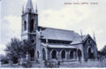
Wesleyan Church, Quetta
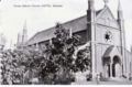
Roman Catholic Church, Quetta
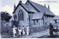
St Lukes Church, Quetta


Missions
- Church Missionary Society
- Church of England Zanana Missionary Society (zanana=women)
Further Reading
A Nursing Sister in Baluchistan by J M Morris (1932) No Preview Google Books. Experiences at a mission hospital in Quetta from 1921. Available at the British Library.
External Link
- Quetta Wikipedia
- History of Quetta Wikipedia
- Bruce Street (now Jinnah Road) before 1935 earthquake.(youtube video)
- Post office before and after earthquake (1935) (youtube video)
Historical books on-line
A gazetteer of the countries adjacent to India on the northwest Volume 2 by Edward Thornton 1844 Shawl - scroll to page 187 Google Books