Quetta
| Quetta | |
|---|---|

| |
| Presidency: | |
| Coordinates: | 30.200602°N 67.034018°E |
| Altitude: | 1,900 m (6,230 ft) |
| Present Day Details | |
| Place Name: | Quetta |
| State/Province: | Balochistan |
| Country: | Pakistan |
| Transport links | |
| North Western Railway | |
| FibiWiki Maps | |
|---|---|
| See our interactive map of this location showing places of interest during the British period | |
| [xxxxx Quetta] |
Quetta, also known as Shawl, was the headquarters of Quetta-Pishin District of Baluchistan Province during the British period. It is now the largest city and provincial capital of Balochistan.
It was the location of a cantonment. There was a Barracks known as Roberts Barracks.
The Army Staff College moved to Quetta in 1907. Established in 1905, it was a training college for existing officers to become eligible for Staff appointments. It is now known as the Command and Staff College and is the most prestigious institution of the Pakistan Army.
Contents
Spelling variants
Modern spelling: Quetta
Variants: Kwettah/Kwatah/Shawl/Shal/Shalkot
Social Life
Clubs
- Quetta Club (1879)
Related Fibiwiki Pages
- Quetta earthquake 1935
Military history
FIBIS Resources
Churches and Missions
Churches
- Mission Church (1903)
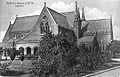
Wesleyan Church, Quetta
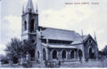
Roman Catholic Church, Quetta
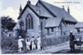
St Lukes Church, Quetta
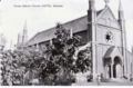
St Mary's Church, Quetta


Missions
- Church Missionary Society
- Church of England Zanana Missionary Society (zanana=women)
Cemeteries
A BACSA (British Association for Cemeteries in South Asia) cemetery publication is
- Quetta: Monuments and Inscriptions by Susan Farrington, 1992 Covers the cemeteries, town's history, the staff college, railways, churches and the 1935 earthquake. See BACSA Books.
BACSA are in the process of putting the indexes to its cemetery books online and these indexes are free to browse. If an indexed name is of interest then application can be made to BACSA for details of the relevant burial inscription - charges apply for this service.
The BACSA Archive at the British Library has the following items:
shelfmark Mss Eur F370: Cemetery Files
no.740: Quetta 1, Pakistan: Baleli Road: 1884-, [Note: This cemetery is probably the "Quetta Cantonment Christian Cemetery on Baleli Road"][1]
no.741: Quetta 2, Pakistan: Shaldara: closed; Lytton Road: closed; Earthquake [Note: Lytton Road is now known as Zarghoon Road]
Maps
- Map of Quetta Civil Station Surveyed 1911-12 Corrected 1931-32 Balochistan Archives
External links
- Quetta Town Imperial Gazetteer of India
- Quetta Wikipedia
- History of Quetta Wikipedia
- Command and Staff College, Quetta pakistanarmy.gov.pk. It moved to Quetta in 1907.
- Bruce Street (now Jinnah Road) before 1935 earthquake.(youtube video)
- Post office before and after earthquake (1935) (youtube video)
- Pen and ink drawing of the military cantonment at Quetta by George Boyd (1800-1850), dated between 1821 and 1844 with a description British Library Images online
- Gora Kubristan Quetta: British colonial christian cemetery Quetta by quettabalochistan, YouTube video
- Quetta's eloquent graveyard A set of photographs by saaakif taken 2008. flickr.com
- Quetta Sphinx (c1930)thefridaytimes.com Photograph of the memorial known as the Quetta Sphinx for the Second Battalion of the Gloucestershire Regiment in respect of those who died in Baluchistan/Southern Afghanistan circa October 1880-January 1883. This memorial has now been destroyed.
- "‘Mum’my dearest!" by Muhammad Adil Mulki April 15, 2012 tribune.com.pk
- Note about the Afghan War Cemetery at Quetta by H Bullock, situated near the village of Kasi , two miles from Quetta. Contains men who died during the 1st Afghan War. Lists four names and advises a large number of NCOs and men of the 40th Regiment of Foot were buried here. Notes and Queries Volume CLXIII, Issue Oct 29 1932,' page 312
- Photographs: Quetta Before 1935 Earthquake June 18, 2007 quetta-city.blogspot
- Postcard: Lytton Road, Winter, Quetta Images of Asia
- Libraries and Collections In Balochistan Balochistan Archives
- Brewing in 19th-century India mentions the brewery at Quetta.
Historical books on-line
- A gazetteer of the countries adjacent to India on the northwest Volume 2 by Edward Thornton 1844 Shawl - scroll to page 187 Google Books
- Quetta in 1878 page 7 The Indian Borderland, 1880-1900 by Colonel Sir T Hungerford Holdich 1901 Archive.org
- Baluchistan District Gazetteer Series: Quetta-Pishin District Vol.V 1907. Pdf to download, Digital Library of India.
- Seven Cantonments by Major SEG Ponder c 1938. Pdf download, Digital Library of India.The author was an Officer in the Royal Artillery, based on the North-West Frontier, including Peshawar, c 1930s. There is an indication elsewhere that he was with a R A Mountain Battery unit which served during the Quetta Earthquake.
- From Semaphore to Satellite: The memoirs of Major General David Horsfield, Royal Signals. The author spent time at the Staff College at Quetta, both as a student and later an instructor, from 1944. davidhorsfield.org.uk
References