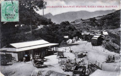
Dharampur, Gujarat: Difference between revisions
Jump to navigation
Jump to search
create page |
transport links |
||
| Line 7: | Line 7: | ||
|stateprovince= [http://en.wikipedia.org/wiki/Himachal_Pradesh Himachal Pradesh] | |stateprovince= [http://en.wikipedia.org/wiki/Himachal_Pradesh Himachal Pradesh] | ||
|country= [http://en.wikipedia.org/wiki/India India] | |country= [http://en.wikipedia.org/wiki/India India] | ||
|transport=[[Kalka-Simla Railway]] | |||
}} | }} | ||
Territory of the Maharaja of Patiala and home of the King Edward Consumption Hospital | Territory of the Maharaja of Patiala and home of the King Edward Consumption Hospital | ||
[[Category:Locations]] | [[Category:Locations]] | ||
[[Category:Princely States]] | [[Category:Princely States]] | ||
Revision as of 21:41, 20 April 2010
| Dharampur, Gujarat | |
|---|---|

| |
| Presidency: Bengal | |
| Coordinates: | 30.897792°N 77.0152438°E |
| Altitude: | 74 m (243 ft) |
| Present Day Details | |
| Place Name: | Dharampur |
| State/Province: | Himachal Pradesh |
| Country: | India |
| Transport links | |
| Kalka-Simla Railway | |
Territory of the Maharaja of Patiala and home of the King Edward Consumption Hospital