Ali Masjid
| Ali Masjid | |
|---|---|

| |
| Presidency: Bengal | |
| Coordinates: | 34.043972°N 71.250433°E |
| Altitude: | 835 m (2,742 ft) |
| Present Day Details | |
| Place Name: | Ali Masjid |
| State/Province: | Federally Administered Tribal Areas (FATA) |
| Country: | Pakistan |
| Transport links | |

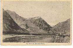
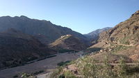
Ali Masjid is a town in the Khyber Pass, present day Khyber Agency of the Federally Administered Tribal Areas (FATA), Pakistan. During the British era, a fort was constructed on the top of a mountain.
Name origin
According to locals, it is named Ali after Prophet Muhammad's cousin.
History
- Occupation of Ali Masjid Fort in the 1st Afghan War
- Attempt to hold Ali Masjid Fort in the 1st Afghan War
- Battle of Ali Masjid Fort in the 2nd Afghan War
Sites of interest
- Fort
- Buddhist stupas
- Graves of British Soldiers
- Mosque