Naini Tal
| Naini Tal | |
|---|---|

| |
| Presidency: Bengal | |
| Coordinates: | 29.38°N, 79.45°E |
| Altitude: | 2,084 m (6,837 ft) |
| Present Day Details | |
| Place Name: | Nainital |
| State/Province: | Uttarakhand |
| Country: | India |
| Transport links | |
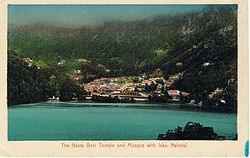
Naini Tal is a hill station in the Kumaon foothills of the outer Himalayas. There was a cantonment located there.
Spelling Variants
Modern name: Nainital
Variants: Nynee Tal/Naini Tal
Surrounding area
Bhim Tal , modern name Bhimtal (Wikipedia) is situated 22 kilometres from Naini Tal . It was the location of a Boer prisoner of war camp , established in 1902 at the north end of the lake, according to this link[1]
Approximately 65 kilometres (40 miles) from Nainital is the Jim Corbett National Park The author of this India List post has happy memories of her young days in the forests of Kumaon near the Jim Corbett National Park.
External links
- Nainital Tourism
- History of Nainital
- Churches in In & Around Nainital District Includes St John In The Wilderness Church
- Rare Old British Era Picture Gallery Of Nainital
- Photograph of St. John's Church, Nainital apparently now derelict. trekearth.com
Historical books online
- "Naini Tal Town" Imperial Gazetteer of India, Volume 18, page 333.
- "Map of Naini Tal", between pages 282 and 283, A Handbook for Travellers in India, Burma, and Ceylon published by John Murray, London Eighth Edition 1911 Archive.org.
- "Nynee Tal" from "A Sketch of the Physical and Topographical Characters and Other Relations of the Hill Sanitaria of Darjeeling, Nynee Tal, Landour and Murree, in the Bengal Presidency", page 307 Army Medical Department: Report for the Year 1862 Google Books