Dera Ismail Khan
Jump to navigation
Jump to search
| Dera Ismail Khan | |
|---|---|
| [[Image:|250px| ]] | |
| Presidency: Bengal | |
| Coordinates: | 31.816667°N 70.916667°E |
| Altitude: | 165 m (541 ft) |
| Present Day Details | |
| Place Name: | Dera Ismail Khan |
| State/Province: | Khyber Pakhtunkhwa, old NWFP |
| Country: | Pakistan |
| Transport links | |
Dera Ismail Khan was the capital of Dera Ismail Khan District in the North West Frontier Province during the British period. In the 1920s it was always referred to as D.I.K. [1]
Contents
Churches
- St Thomas Church.
Cemeteries
Comment on FIBIS’s Facebook page 11 August 2013 by Shahjahan Bhatti "There is graveyard on River Indus in Dera Ismail Khan. All graves are of English people who died here. .. I have witnessed around hundred cemented graves with a cemented boundry wall. The cemetery is situated in cantonement area where these days civilians are not allowed...". Comment by Omer Khan "I thought that there was an old Christian graveyard near the old Anglican Church..."
- BACSA cemetery file - Dera Ismail Khan Cemetery , Pakistan (closed 1871). British Library ref Mss Eur F370/694
- Just over a dozen graves in both old and new cemeteries have been transcribed in A list of inscriptions on Christian tombs or monuments in the Punjab, North-West Frontier Province, Kashmir and Afghanistan possessing historical or archaeological interest Part 1 by Miles Irving (1910), page 174. Hathi Trust Digital Library
Gallery
Click on the image thumbnails below to find out more about these images.
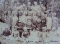
A class of students of Dera Ismail Khan 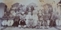
Probably the farewell of Abdullah Khan 1914 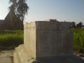
Tomb- Sir Henry Marion Durand, in the compound of St. Thomas's Church 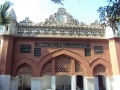
Victoria Bharatari High School Dera Ismail Khan 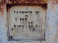
Commemorative Plaque in Vedic Bharatari (V.B) College Dera Ismail Khan 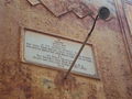
Plaque in the memory of Rai Tehl Ram Bagai at Vedic Bharatari (V.B) College Dera Ismail Khan


Other FIBIS Resources
External Links
- Photograph: Dera, Church in Cantt by Mudasir Hassan uploaded April 18, 2009 panoramio.com, now archived. Probably St. Thomas's Church
- "Opening Up of Baluchistan" "Motor Road through the Mountains to link Dera Ismail Khan with Fort Sandeman. Bridle paths running through the Takht-i-Sulaiman mountains are being transformed into a motor highway". The Straits Times, 28 April 1940, Page 12. Newspapers-Singapore Government.
- "D. I. Khan: How cities change" by Prof. Dr. Mansoor Akbar Kundi June 28th, 2009 The Pakistani Spectator. now archived.
- Church is melancholy reminder of region's rebellions Article detailing condition of St Thomas's Church and Memorial Inscriptions in Dera Ismail Khan. telegraph.co.uk
Historical books online
- "Waziristan District" by Lieutenant-Colonel B. B. Burke Journal of the Royal Army Medical Corps 1925;44:3 pages 204-207. "Every officer must carry a loaded revolver when travelling on account of the possibility of fanatical attacks".
References
- ↑ "Notes on a Tour Through Waziristan" by Major A. D. Stirling Journal of the Royal Army Medical Corps 1927;49:2 pages 143-151.