Difference between revisions of "Gujranwala District"
Jump to navigation
Jump to search
(modern divisions added) |
Symorsebrown (talk | contribs) (Add internal link, external link) |
||
| (2 intermediate revisions by one other user not shown) | |||
| Line 9: | Line 9: | ||
}} | }} | ||
| − | '''Gujranwala District''' was part of [[Lahore Division]] of [[Punjab]]. | + | '''Gujranwala District''' was part of [[Lahore Division]] of [[Punjab|Punjab Province]] during the British period. |
==Headquarters== | ==Headquarters== | ||
| + | * 1849 to 1851: Fort at [[Sheikhupura]] | ||
* [[Gujranwala]] | * [[Gujranwala]] | ||
| − | |||
==Neighbours== | ==Neighbours== | ||
| − | * North-Western: | + | * North-Western: River Chenab |
* South: [[Lahore District]] | * South: [[Lahore District]] | ||
* North East: [[Sialkot District]] | * North East: [[Sialkot District]] | ||
| − | |||
==Area== | ==Area== | ||
* 1881: 2,587 square miles | * 1881: 2,587 square miles | ||
| − | |||
==Population== | ==Population== | ||
* 1881: 616, 892. | * 1881: 616, 892. | ||
| − | |||
==History== | ==History== | ||
| − | |||
| − | |||
==Geography== | ==Geography== | ||
| − | |||
| − | |||
==Cities and Towns== | ==Cities and Towns== | ||
| Line 43: | Line 36: | ||
* [[Sheikhupura]] | * [[Sheikhupura]] | ||
* [[Wazirabad]] | * [[Wazirabad]] | ||
| − | |||
==Sub-divisions== | ==Sub-divisions== | ||
| Line 50: | Line 42: | ||
* Hafizabad | * Hafizabad | ||
* Wazirabad | * Wazirabad | ||
| − | |||
==Transportation== | ==Transportation== | ||
| − | ===Rail=== | + | ====Rail==== |
* [[Punjab Northern State Railway]] | * [[Punjab Northern State Railway]] | ||
| − | + | ====Road==== | |
| − | ===Road=== | ||
* The Grand Trunk (G.T.) Road passes through here. | * The Grand Trunk (G.T.) Road passes through here. | ||
| − | |||
==Reading== | ==Reading== | ||
* Gazetteer of the Gujranwala District 1883-4, Lahore. Reprinted by Sang-e-Meel Publications, Lahore 2004 | * Gazetteer of the Gujranwala District 1883-4, Lahore. Reprinted by Sang-e-Meel Publications, Lahore 2004 | ||
| − | |||
==External Links== | ==External Links== | ||
| − | * [http://en.wikipedia.org/wiki/Gujranwala_District Gujranwala District | + | *[http://dsal.uchicago.edu/reference/gazetteer/pager.html?objectid=DS405.1.I34_V22_332.gif Gujranwala District] Imperial Gazetteer |
| − | * [http://en.wikipedia.org/wiki/Hafizabad_District Hafizabad District | + | * [http://en.wikipedia.org/wiki/Gujranwala_District Gujranwala District] Wikipedia |
| + | * [http://en.wikipedia.org/wiki/Hafizabad_District Hafizabad District] Wikipedia | ||
[[Category:Locations]] | [[Category:Locations]] | ||
| − | |||
[[Category:Districts]] | [[Category:Districts]] | ||
Revision as of 10:29, 29 July 2012
| Gujranwala District | |
|---|---|

| |
| Presidency: Bengal | |
| Coordinates: | |
| Altitude: | |
| Present Day Details | |
| Place Name: | Gujranwala District, Hafizabad District, Nankana Sahib District, Sheikhupura District |
| State/Province: | Punjab |
| Country: | Pakistan |
| Transport links | |
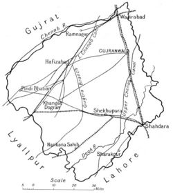
Gujranwala District was part of Lahore Division of Punjab Province during the British period.
Contents
Headquarters
- 1849 to 1851: Fort at Sheikhupura
- Gujranwala
Neighbours
- North-Western: River Chenab
- South: Lahore District
- North East: Sialkot District
Area
- 1881: 2,587 square miles
Population
- 1881: 616, 892.
History
Geography
Cities and Towns
In 1881, there were 1,146 towns and villages in the district.
- Gujranwala
- Hafizabad
- Sheikhupura
- Wazirabad
Sub-divisions
There were three tehsils:
- Gujranwala
- Hafizabad
- Wazirabad
Transportation
Rail
Road
- The Grand Trunk (G.T.) Road passes through here.
Reading
- Gazetteer of the Gujranwala District 1883-4, Lahore. Reprinted by Sang-e-Meel Publications, Lahore 2004
External Links
- Gujranwala District Imperial Gazetteer
- Gujranwala District Wikipedia
- Hafizabad District Wikipedia