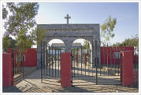
Jacobabad
Jump to navigation
Jump to search
| Jacobabad | |
|---|---|
| [[Image:|250px| ]] | |
| Presidency: Bombay | |
| Coordinates: | 28.276944°N 68.451389°E |
| Altitude: | 55m (180 ft) |
| Present Day Details | |
| Place Name: | Jacobabad |
| State/Province: | Sindh |
| Country: | Pakistan |
| Transport links | |
| North Western Railway | |
| FibiWiki Maps | |
|---|---|
| See our interactive map of this location showing places of interest during the British period | |
| [xxxxx Jacobabad] |
Contents
THIS PAGE IS WAITING FOR MORE DETAILED INFORMATION
Jacobabad was the chief town and headquarters of the Upper Sind Frontier District of the Sind division of Bombay Presidency during the British period.
Spelling variants
Modern name: Jacobabad
Variants: Yaqubabad
Former name: Khangharh
History
Founded on the site of the village of Khangharh by Major (later Brigadier-General) John Jacob in 1847. A town municipality was established in 1878.
Health
- Civil Hospital
Government Buildings
- Residency
- Army Remount stables
- Kacheri (law courts)
- Municipal Office
- Veterinary Dispensary
Military
The cantonment was located to the left of the Residency. It was abolished in 1914.
Transportation
Railways
Jacobabad was a station on the Quetta-Pishin line of the North Western Railway.
Sites of Interest
- Residency of General John Jacob
- Tomb of General Jacob
- Victoria Clock Tower (1887)
Further Reading
- Smyth, J. W. "Gazetteer of the Province of Sind volume VII Upper Sind Frontier District," Bombay 1919. Reprinted by Sang-e-Meel Publications, Lahore 2005
External links
Jacobabad Town Imperial Gazetteer
Brigadier General John Jacob CB of Jacobabad 1812 – 1858 www.myjacobfamily.com
Historical books online
- Obituary of John Jacob, commander of the Scinde Horse, died 1858 at Jacobabad. Google Books

