Difference between revisions of "Junagadh State Railway"
(Railway Logo added) |
(1937 Report info added, layout changes , Statisics added and Classification) |
||
| Line 30: | Line 30: | ||
|system3details= | |system3details= | ||
}} | }} | ||
| + | |||
| + | Also known as '''Junagad State Railway''' | ||
The '''Junagadh State Railway''' (JunSR) was a metre gauge([[Rail_gauge_#Metre_Gauge|MG]]) railway owned by the [[Princely states|Princely ]][[Junagadh State]] and initially worked by the ‘[[Bhavnagar-Gondal-Junagad-Porbandar Railway]]’ <ref>[https://archive.org/stream/BombayBarodaAndCentralIndiaRailwaySystem/Bombay_Baroda_And_Central_India_Railway_System#page/n201/mode/1up "Administration Report on the Railways in India – corrected up to 31st March 1918"; Superintendent of Government Printing, Calcutta; page 193]; Retrieved 7 Feb 2016</ref> | The '''Junagadh State Railway''' (JunSR) was a metre gauge([[Rail_gauge_#Metre_Gauge|MG]]) railway owned by the [[Princely states|Princely ]][[Junagadh State]] and initially worked by the ‘[[Bhavnagar-Gondal-Junagad-Porbandar Railway]]’ <ref>[https://archive.org/stream/BombayBarodaAndCentralIndiaRailwaySystem/Bombay_Baroda_And_Central_India_Railway_System#page/n201/mode/1up "Administration Report on the Railways in India – corrected up to 31st March 1918"; Superintendent of Government Printing, Calcutta; page 193]; Retrieved 7 Feb 2016</ref> | ||
| Line 39: | Line 41: | ||
<br>Initially described as the '''Junadagh-Veraval Railway'''. | <br>Initially described as the '''Junadagh-Veraval Railway'''. | ||
| − | + | ==Administration== | |
| − | |||
| − | == | ||
*1888-89: With the opening of the ‘Junagadh State Railway’(JunSR ) from [[Junagadh]] via [[Jetalsar]] to [[Veraval]] the railway joined the administrative coalition of the '[[Bhavnagar-Gondal State Railway]]’. <br>The coalition briefly became the '[[Bhavnagar-Gondal-Junagad-Veraval Railway]]'(BGJPV) | *1888-89: With the opening of the ‘Junagadh State Railway’(JunSR ) from [[Junagadh]] via [[Jetalsar]] to [[Veraval]] the railway joined the administrative coalition of the '[[Bhavnagar-Gondal State Railway]]’. <br>The coalition briefly became the '[[Bhavnagar-Gondal-Junagad-Veraval Railway]]'(BGJPV) | ||
*1889: When the ‘[[Porbandar State Railway]]’ extension from [[Dhasa ]] reached [[Porbandar]] the coalition finally became the [[Bhavnagar-Gondal-Junagad-Porbandar Railway| '''Bhavnagar-Gondal-Junagad-Porbandar Railway'''(BGJPR) ''- see separate page for further information'']]. | *1889: When the ‘[[Porbandar State Railway]]’ extension from [[Dhasa ]] reached [[Porbandar]] the coalition finally became the [[Bhavnagar-Gondal-Junagad-Porbandar Railway| '''Bhavnagar-Gondal-Junagad-Porbandar Railway'''(BGJPR) ''- see separate page for further information'']]. | ||
| Line 53: | Line 53: | ||
==Development of the Junagadh State Railway== | ==Development of the Junagadh State Railway== | ||
| + | [[File:Junagadh State Railway 1931 Map.png|thumb|Junagadh State Railway 1931 Map]] | ||
| + | [[File:Junagadh State Railway 1938 Schematic Map.png|thumb|Junagadh State Railway 1938 Scematic Map]] | ||
*The first section from [[Jetalsar]] to [[Junagadh]] opened in 1888 and extended to [[Veraval|Veraval Docks]] in 1889, a total of 67 miles(108km) <ref name=Admin>[https://archive.org/stream/BombayBarodaAndCentralIndiaRailwaySystem/Bombay_Baroda_And_Central_India_Railway_System#page/n201/mode/1up "Administration Report on the Railways in India – corrected up to 31st March 1918"; Superintendent of Government Printing, Calcutta; page 193]; Retrieved 23 Jun 2019</ref>. At [[Jetalsar |Jetalasar Junction]] there was a connection to the ‘[[Gondal Railway]] - Mainline’ [[Dhasa]] to [[Jamjodhpur]]. | *The first section from [[Jetalsar]] to [[Junagadh]] opened in 1888 and extended to [[Veraval|Veraval Docks]] in 1889, a total of 67 miles(108km) <ref name=Admin>[https://archive.org/stream/BombayBarodaAndCentralIndiaRailwaySystem/Bombay_Baroda_And_Central_India_Railway_System#page/n201/mode/1up "Administration Report on the Railways in India – corrected up to 31st March 1918"; Superintendent of Government Printing, Calcutta; page 193]; Retrieved 23 Jun 2019</ref>. At [[Jetalsar |Jetalasar Junction]] there was a connection to the ‘[[Gondal Railway]] - Mainline’ [[Dhasa]] to [[Jamjodhpur]]. | ||
| − | * Initially described as the '''Junadagh-Veraval Railway''' | + | * Initially described as the '''Junadagh-Veraval Railway''' and became the ‘Main Line’ |
**''Line ‘A’ on 1931 and 1938 maps '' | **''Line ‘A’ on 1931 and 1938 maps '' | ||
*1910-15: ‘Saradiya Branch Line’, 26 miles(42km); from Shapur , 5 miles(8km) south-west of Junagadh, to Saradiya <ref name=Admin/> (shown as Juniagarh to Kutiyana on 1931 Railways Map ) | *1910-15: ‘Saradiya Branch Line’, 26 miles(42km); from Shapur , 5 miles(8km) south-west of Junagadh, to Saradiya <ref name=Admin/> (shown as Juniagarh to Kutiyana on 1931 Railways Map ) | ||
| Line 64: | Line 66: | ||
* 1918-23: ‘Veraval-Prachi Road Branch’, 28 miles(45km); from [[Veraval]], proposed as far as [[Una]], delayed start, opened in stages from 1918, reached Prachi Road 1923 <ref name=page193>[https://ia801602.us.archive.org/6/items/in.ernet.dli.2015.96301/2015.96301.Kathiawar-Economics.pdf 1943 ‘Kathiawar Economics’ by A B Trivedi, 1943 Digital Library of India Archive.org, Appendix B ‘Railways in Kathiawar with opening dates, pages 193(pdf217)]</ref>. | * 1918-23: ‘Veraval-Prachi Road Branch’, 28 miles(45km); from [[Veraval]], proposed as far as [[Una]], delayed start, opened in stages from 1918, reached Prachi Road 1923 <ref name=page193>[https://ia801602.us.archive.org/6/items/in.ernet.dli.2015.96301/2015.96301.Kathiawar-Economics.pdf 1943 ‘Kathiawar Economics’ by A B Trivedi, 1943 Digital Library of India Archive.org, Appendix B ‘Railways in Kathiawar with opening dates, pages 193(pdf217)]</ref>. | ||
**''Line ‘E’ on 1931 and 1938 maps '' | **''Line ‘E’ on 1931 and 1938 maps '' | ||
| − | * 1932: ‘Visavader-Dhari Branch’ 20 miles(32km); from Visavader to Dhari <ref name=page193/> | + | * 1932: ‘Visavader-Dhari Branch’ 20 miles(32km); from Visavader to Dhari <ref name=page193/> |
**''Line ‘F’ on 1938 map '' | **''Line ‘F’ on 1938 map '' | ||
| − | * 1934-35: ‘Prachi Road-Jamwala- | + | * 1934-35: ‘Prachi Road-Jamwala-Delvada Branch’ 31 miles(50km) <ref name=page193/>. This was an extension to the ‘Veraval-Prachi Road Branch’ (Line ‘E’ above) and on reaching Delvada in 1935 became renamed ‘Una Branch’, with a total length from Veraval to Delvada of 25 miles(95km) <ref name=Hist>[https://ia801605.us.archive.org/30/items/in.ernet.dli.2015.36650/2015.36650.India-Railway-Board-History-Of-Indian-Railways-Constructed-And-In-Progress.pdf US Archive .org pdf download of ‘History Of Indian Railways, constructed and in progress’, 31 March 1937 by ‘The Government of India - Railway Department’ page 245 pdf 288]; Retrieved 23 Aug 2020</ref>. |
**''Line ‘G’ on 1938 map '' | **''Line ‘G’ on 1938 map '' | ||
*1936-37: ‘[[Talala-Visavadar Railway]]’' via Sasan Gir, 29½ miles(47km) MG, constructed by the JunSR.[[Talala-Visavadar Railway|''See separate page'']] | *1936-37: ‘[[Talala-Visavadar Railway]]’' via Sasan Gir, 29½ miles(47km) MG, constructed by the JunSR.[[Talala-Visavadar Railway|''See separate page'']] | ||
| + | |||
| + | The ‘Statistics of Working’ show the year-by-year financial results from 1913-14 through to 1936-37 with a total route length of 229 miles(369km) | ||
| + | <ref name=Hist> | ||
| + | |||
| + | == Classification == | ||
| + | [[Indian Railway Classification]] of 1926 - Class III railway system. | ||
==Further Information== | ==Further Information== | ||
Latest revision as of 06:50, 24 August 2020
| Junagadh State Railway | ||
|---|---|---|
 Junagadh State Railway Logo. | ||
| Line of route | ||
| Jetalsar to Veraval | ||
| Gauge / mileage | ||
| Metre gauge | 140 miles (1922) 229 miles (1944) | |
| Timeline | ||
| 1888 | First section opened to traffic | |
| Key locations | ||
| Presidency | Bombay | |
| Stations | Jetalsar, Junagadh, Kutiyana, Veraval | |
| System agency | ||
| 1888 | Bhavnagar-Gondal-Junagad-Porbandar Railway | |
| 1911 | Own agency | |
| How to interpret this infobox | ||
Also known as Junagad State Railway
The Junagadh State Railway (JunSR) was a metre gauge(MG) railway owned by the Princely Junagadh State and initially worked by the ‘Bhavnagar-Gondal-Junagad-Porbandar Railway’ [1]
In 1869 a survey was undertaken and the ’Junagadh-Veraval Railway Proposal ‘ concluded that a Railway line from Junagadh to Veraval was feasible but the cost of 40 to 50 Lakhs of Rupees was too high for the Junagadh Durbar to go ahead. Proposals for a light railway system were to be looked at. [2].
In 1872 another line was proposed and the route from Veraval to Junagadh and Dhoraji was surveyed by Mr A W Forde C E, but the cost was beyond the means of Junagadh Durbar. This proposal came to nothing [3].
Construction finally commenced in 1886 from Jetalsar to Junagadh City in 1888 and onward To Veraval 1889,
Initially described as the Junadagh-Veraval Railway.
Contents
Administration
- 1888-89: With the opening of the ‘Junagadh State Railway’(JunSR ) from Junagadh via Jetalsar to Veraval the railway joined the administrative coalition of the 'Bhavnagar-Gondal State Railway’.
The coalition briefly became the 'Bhavnagar-Gondal-Junagad-Veraval Railway'(BGJPV) - 1889: When the ‘Porbandar State Railway’ extension from Dhasa reached Porbandar the coalition finally became the Bhavnagar-Gondal-Junagad-Porbandar Railway(BGJPR) - see separate page for further information.
- This BGJPR coalition was also described in some records as the Kathiawar Railway,
- also as the Kathiawar Union Railway
- also as the Kathiawar State Railway.
- 1911: The BGJPR coalition ceased to exist on 1 April 1911, from this date the line was worked independently as a separate and distinct railway [4].
- 1911-1934: The operation of the ‘Jetalsar-Rajkot Railway’ caused serious financial and commercial disadvantages to the JunSr, resulting in acrimonious exchanges over many years - see separate page for further information.
- 1935: The ‘Junagadh State Railway’ put forward a proposal to take over the management of the ‘Jetalsar-Rajkot Railway’ which since 1911 had been operated by the ‘Gondal-Porbandar Railway’ [5]. There is no evidence that this proposal was accepted.
- 1948: The ‘Junagadh State Railway’ became part of the ‘Saurashtra Railway’.
Development of the Junagadh State Railway
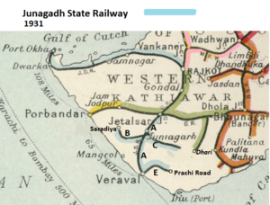
- The first section from Jetalsar to Junagadh opened in 1888 and extended to Veraval Docks in 1889, a total of 67 miles(108km) [4]. At Jetalasar Junction there was a connection to the ‘Gondal Railway - Mainline’ Dhasa to Jamjodhpur.
- Initially described as the Junadagh-Veraval Railway and became the ‘Main Line’
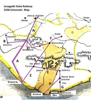
- Line ‘A’ on 1931 and 1938 maps
- 1910-15: ‘Saradiya Branch Line’, 26 miles(42km); from Shapur , 5 miles(8km) south-west of Junagadh, to Saradiya [4] (shown as Juniagarh to Kutiyana on 1931 Railways Map )
- Line ‘B’ on 1931 and 1938 maps
- 1912: ‘Visavadar Branch’, 26 miles(km); from Junagadh to Visavadar [4] .
- Line ‘C’ on 1931 and 1938 maps
- 1912: ‘Dungarpur Quarry Line’, ¾ mile(1.2km); a short spur from the ‘Visavadar Branch’, 2 miles (3.2km) south-east of Junagarh [4] .
- Line ‘D’ on 1938 map
- 1918-23: ‘Veraval-Prachi Road Branch’, 28 miles(45km); from Veraval, proposed as far as Una, delayed start, opened in stages from 1918, reached Prachi Road 1923 [6].
- Line ‘E’ on 1931 and 1938 maps
- 1932: ‘Visavader-Dhari Branch’ 20 miles(32km); from Visavader to Dhari [6]
- Line ‘F’ on 1938 map
- 1934-35: ‘Prachi Road-Jamwala-Delvada Branch’ 31 miles(50km) [6]. This was an extension to the ‘Veraval-Prachi Road Branch’ (Line ‘E’ above) and on reaching Delvada in 1935 became renamed ‘Una Branch’, with a total length from Veraval to Delvada of 25 miles(95km) [7].
- Line ‘G’ on 1938 map
- 1936-37: ‘Talala-Visavadar Railway’' via Sasan Gir, 29½ miles(47km) MG, constructed by the JunSR.See separate page
The ‘Statistics of Working’ show the year-by-year financial results from 1913-14 through to 1936-37 with a total route length of 229 miles(369km) <ref name=Hist>
Classification
Indian Railway Classification of 1926 - Class III railway system.
Further Information
See Bhavnagar-Gondal-Junagad-Porbandar Railway for period from 1899 to 1911.
and Kathiawar Peninsula Railway and Tramway Systems gives a map, timeline and relates this railway to others in the Kathiawar Peninsula.
References
- ↑ "Administration Report on the Railways in India – corrected up to 31st March 1918"; Superintendent of Government Printing, Calcutta; page 193; Retrieved 7 Feb 2016
- ↑ British Library ‘India Office Records’ V/10/1384 “Indian States Administration Reports. Kathiawar” 1865-75, No 134 of 1869
- ↑ “Gazetteer – Bombay Presidency” Vol.8; page 247-248 of 756; Retrieved 1 Oct 2017
- ↑ 4.0 4.1 4.2 4.3 4.4 "Administration Report on the Railways in India – corrected up to 31st March 1918"; Superintendent of Government Printing, Calcutta; page 193; Retrieved 23 Jun 2019
- ↑ British Library IOR/R/1/1/4784(1) and (2); "File 110-IB(C)/1935 Proposed taking over of management of the Jetalsar-Rajkot Railway by the Junagadh State Railway from the Gondal Railway"; 1935
- ↑ 6.0 6.1 6.2 1943 ‘Kathiawar Economics’ by A B Trivedi, 1943 Digital Library of India Archive.org, Appendix B ‘Railways in Kathiawar with opening dates, pages 193(pdf217)
- ↑ US Archive .org pdf download of ‘History Of Indian Railways, constructed and in progress’, 31 March 1937 by ‘The Government of India - Railway Department’ page 245 pdf 288; Retrieved 23 Aug 2020

