Karachi
| Karachi | |
|---|---|

| |
| Presidency: Bombay | |
| Coordinates: | 24.86°N 67.01°E |
| Altitude: | 8 m (26 ft) |
| Present Day Details | |
| Place Name: | Karachi |
| State/Province: | Sindh |
| Country: | Pakistan |
| Transport links | |
| Kotri-Rohri Railway | |
| FibiWiki Maps | |
|---|---|
| See our interactive map of this location showing places of interest during the British period | |
| Karachi |
During the British period Karachi was the headquarters of Karachi District and the capital of the Sind division of Bombay Presidency from 1840s until 1936. See Bombay Districts. Sind was an independent province from 1936 till Partition in 1947.
Contents
- 1 Spelling variants
- 2 History
- 3 Places of Worship
- 4 Cemeteries
- 5 Military
- 6 Clubs and Associations
- 7 Buildings
- 8 Monuments
- 9 Markets
- 10 Education
- 11 Newspapers
- 12 Health
- 13 Gardens
- 14 Government Offices
- 15 Economy and business
- 16 Locations
- 17 Transportation
- 18 External Links
- 19 Further Reading
- 20 References
Spelling variants
Modern name: Karachi
Variants: Kurrachee
History

It was occupied by the British in 1839.
- Wikipedia article: History
Places of Worship
Churches
Various denominations existed including Catholic, Anglican and Methodist. The oldest church was St. Patrick's Church (now Cathedral)(1840s) in the Saddar area of the city.
Catholic

Was part of the Vicariate Apostolic of Bombay until 1886. From 1886 to 1947, it was part of the Archdiocese of Bombay.
- Our Lady of Fatima
- Sacred Heart Church, Keamari
- St. Anthony's Church (1935), Cantonment
- St. Anthony's Church, Manora
- St. Christopher's Church, Airport
- St. Lawrence's Church, Soldier Bazar
- St. Patrick's Church (now Cathedral) (1843). Founder: Rev. Casabloch. Note: Started in the premises of St. Joseph's Convent. Present building completed in 1878
Protestant
- Brooks Memorial Methodist Church (1875). Founder: Rev. Frank Ambrose Goodman. Denomination: Methodist
- Holy Trinity Church (now Cathedral). Denomination: Anglican
- St. Andrew's Church (Scotch Church) (1867-68). Denomination: Presbyterian. Photograph Scotch Church of St Andrew's, Karachi c1900 Also Interior of St Andrew's Church, Karachi c1870 images and background details from British Library Gallery online.
- St. Paul's Church, Manora.
Photographs of Churches in Kurrachee (taken in the 1850s- 1870s) skyscrapercity.com
Other places
- Parsi Dar-e-Meher
- Magain Shalome Synagogue (1890s) (demolished in 1980s)
- Various Hindu temples. List
Cemeteries
- Bene Israel Cemetery - Jewish Cemetery In Karachi Documented For First Time Jewish timesasia.org View the documentary film Photographs
- Gora Kabristan
- Karachi War Cemetery
Military
- "Special Sanitary and Topographical Report on Kurrachee" by Surgeon-Major Dr Inglis 64th Regiment, page 349 Army Medical Department: Statistical Sanitary and Medical Reports for the year 1861 (published 1863) Google Books
- "Kurrachee" page 473 Report of the Commissioners Appointed to Inquire into the Sanitary State of the Army in India : with Abstract of Evidence, and of Reports Received from Indian Military Stations 1864 Archive.org
- Photograph: Infantry Barracks, Napier Lines, Kurrachee c 1870 with description British Library Online Gallery
- Bird's eye view Napier Barracks Karachi c 1900 with description A second view c 1900 with description British Library Online Gallery
- Snapshots of Drigh Road RAF Depot, Karachi, now PAF Base Faisal c 1927. T E Lawrence (Lawrence of Arabia) , as Aircraftman T E Shaw, was stationed here in 1927-1928. telstudies.org. Retrieved 21 August 2014
- "Every Day A Bonus" by Ken Clarke from Regimental Association of The Queen's Own Buffs (PWRR): The Journal issues No 11-14 Autumn 2005- Spring 2007. The pages covering the voyage to India in 1933, time in India, and voyage back to England in 1938 are (11)48-49; (12)29-39; (13)15-25; (14)38.
- Issue 11, 12, 13, 14 thequeensownbuffs.com
- Issue 13 includes his experiences with the 1st Battalion, Royal West Kent Regiment in Karachi.
- "Last stop Karachi 1946!" by John ‘Dusty’ Miller Part 1, Part 2. He was a driver in the RAF and was in India 1945-1947, his last posting in Karachi. www.qissa-khwani.com, now archived.
- RAF Karachi (including Drigh Road) rafweb.org. Retrieved 1 July 2014
- RAF Mauripur, in the vicinity of Karachi. rafweb.org. Retrieved 1 July 2014
Clubs and Associations
- see here
Buildings

Cinemas
- Star Cinema (1918)
Halls
- Frere Hall (1865) (Victoria Road)
- Max Denso Hall (Bandar Road)
Hotels
- Bristol Hotel (1910) Photograph Article in Dawn
- Grand Hotel
- Hotel Midway House (KLM built)
- Palace Hotel (now Sheraton Hotel)
Houses
- Mohatta Palace (1920s)
Museums
- Victoria Museum
Monuments
- Merewether Clock Tower (now known simply as Tower) Architecture: Merewether Tower, Karachi
Markets

- see here
Education
- Bai Virbaiji Soparivala (B.V.S.) Parsi High School (only for Parsis until 1947) Alumni website
- Karachi Grammer School (1847)
- Sind Arts College (later DJ College)
- St. Joseph's Convent (1862)History of SJC (official website)
- St. Patrick's High School (1861) official website
- Nadirshah Edulji Dinshaw (NED) College (formerly Prince of Wales Engineering College.) (1922, renamed 1924) official website
Newspapers
- Sind Gazette
Health
Hospitals

- Civil Hospital (1854). Located on Mission Road.
- Lady Dufferin Hospital (1898)
- Spencer Eye Hospital (1938)
Dispensaries
- Eduljee Dinshaw Dispensary (1881-1882)
- Jaffer Fudoo Dispensary
Veterinary Hospitals
- Richmond Crawford Veterinary Hospital
Institutes
- Louise Lawrence Institute (training of midwives) (after 1912)
Gardens

- Burns Garden
- Erskine Garden
- Government Garden/ Company Bagh (1885)/ Rani Bagh/ Gandhi Garden (1933) (now the city zoo)[1]
- Municipal Garden
Government Offices
- Mercantile Marine Department (May 1930)
- Sind Fisheries Department
Economy and business
Locations
This is a list of the major areas, quarters and roads of the city.
Lines
- Civil Lines
- Jacob Lines
- Jutland Lines
- N.I. Lines
- R.A. Lines
Quarters
- Artillery Maidan Quarter
- Frere Quarter
- Jamsheed Quarter
- Napier Quarter
Roads

- Britto Road
- Brunton Road
- Bunder Road (now M.A. Jinnah Road)
- Frere Street
- Jail Road
- Kutchery Road (Law courts)
- Lawrence Road (now Nishtar Road)
- McLeod Road (now II Chundrigar Road)
- Merewether Road
- Mission Road
- Napier Road
- Newnham Road
- Outram Road
- Queen's Road (now M.T. Khan Road)
- Rampart Road
- Scandal Point Road
- Somerset Road
- Victoria Road (now Abdullah Haroon Road)
For more information, visit List of streets of Karachi
Transportation
Railways
There were two stations, McLeod Road Station (now City Station) and Frere Street Station (now Karachi Cantt)
Tramway
- The Karachi Tramway of Yesteryears 14 September 2007 All Things Pakistan, now an archived website.
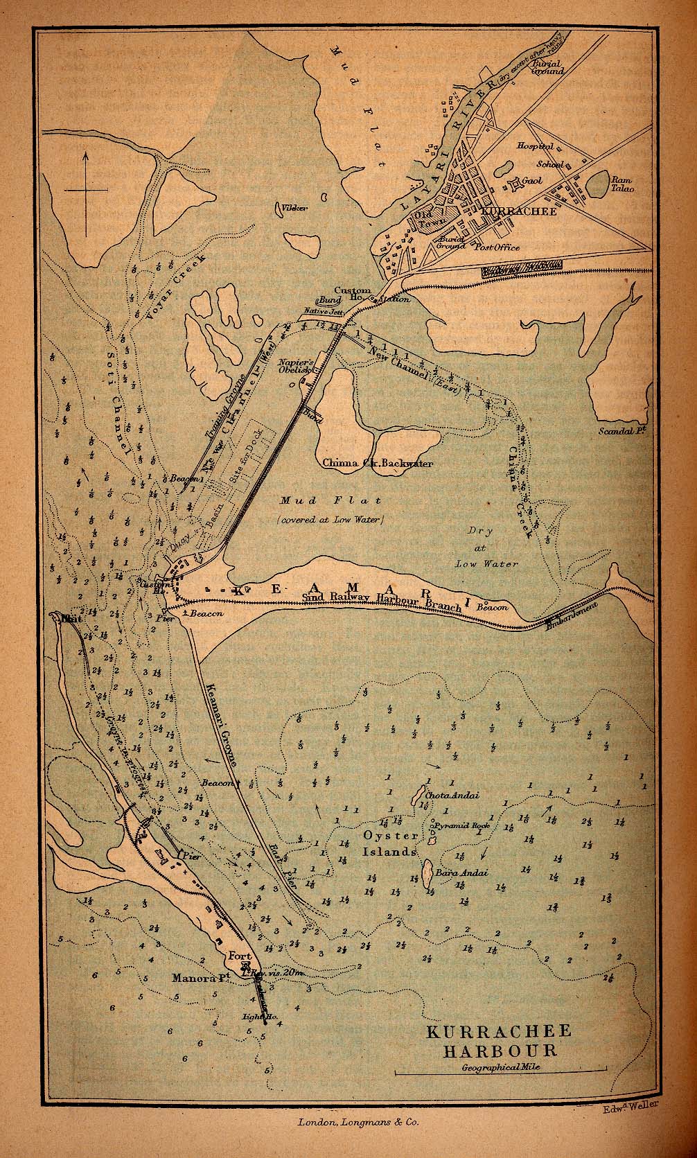
Karachi Harbour

Karachi Port Trust was established by an Act in 1886 (effective 1887) to manage the affairs of the port.
- Kemari (earlier an island, but joined to the mainland)
- Mules MansionThe Karachi Walla
- Napier Mole
External Links
Karachi City Imperial Gazetteer
Maps
Kurrachee Harbour Map 1882 from the Historical Maps of Asia Collection, University of Texas, Austin
Historical books online
- An Account of the Kurachee Municipality, from Its Commencement to the 1st Jan. 1860 by A F Bellasis, late Collector and Magistrate of Kurachee. 1860 Google Books
- The Sind Directory. With a map ... Also, a plan of Kurrachee ... A general description of the Punjab, etc. by George Bease 1862 British Library Digital Collection. Note: There do not appears to be any maps.
- The Tourist's Guide from Delhi to Kurrachee, describing the various towns ... commerce: railways: river communications: &c: &c: with a map. Lahore [c 1865?]. British Library Digital Collection
- The Karachi Handbook & Directory by P Webb 1922. Pdf download, Digital Library of India. Archive.org version. The print quality of some pages is poor.
Booklets
- Guide to Karachi Booklet produced for US Soldiers during WWII. cbi-theater.com
- Special Service Booklet for US Soldiers during WWII. cbi-theater.com
Thesis
- Haider, Azimusshan (1971), History of Karachi with special reference to educational and commercial development (1839-1900), PhD thesis, University of Karachi, Karachi.
- Wajidi, Muhammad Abuzar (1990) KMC (Karachi Municipal Corporation): A study of its administrative and financial organisation PhD thesis, University of Karachi, Karachi.
Other
- "Sugar and Stone" by Peerzada Salman Dawn Sunday 3 April 2011. Article about historical buildings. Unfortunately the article now does not show the photographs originally available.
- Somake`s Karachi by Peerzada Salman Dawn 23 May 2011. Moses Somake, born 1875, was an architect in Karachi
Video
- Christian Cemetery, Karachi BBC Urdu report (in Urdu)
- Karachi and Bombay at the End of the Raj as seen by a British soldier sometime between 1942 and 1947: (updated commentary from the earlier posting Karachi at the End of the Raj YouTube video
- Churches of Karachi Short documentary on their construction/architecture (in Urdu) on youtube
Further Reading
- Lari, Yasmin and Mihail Lari, "The Dual City: Karachi during the Raj" Karachi OUP. 1997. ISBN: 978-0195777352
References
- ↑ Soomro, Durdana, "Pleasure Gardens of a Raj City". Lahore: Sang-e-Meel. 2007 pg 43