Difference between revisions of "Kathiawar"
m |
(1807 info added) |
||
| Line 10: | Line 10: | ||
The peninsula covers an area of 23,345 sq. miles (60,720 sq. Km) and in 1901 had a population of 2,645,805<ref name=gaz15_164>[http://dsal.uchicago.edu/reference/gazetteer/pager.html?objectid=DS405.1.I34_V15_170.gif “Imperial Gazette of India” Vol.15. p.164]; Retrieved 10 Jun 2017</ref>. Most of the area was under the jurisdiction of the [[Government of India]], and also Portugal had the island colony of [[Diu]] on the peninsular which covered 20 sq. miles (51.8sq. Km) with a population of 14,614 <ref name=gaz11_368>[http://dsal.uchicago.edu/reference/gazetteer/pager.html?objectid=DS405.1.I34_V11_368.gif “Imperial Gazette of India” Vol.11. p.362-364]; Retrieved 10 Jun 2017</ref>. | The peninsula covers an area of 23,345 sq. miles (60,720 sq. Km) and in 1901 had a population of 2,645,805<ref name=gaz15_164>[http://dsal.uchicago.edu/reference/gazetteer/pager.html?objectid=DS405.1.I34_V15_170.gif “Imperial Gazette of India” Vol.15. p.164]; Retrieved 10 Jun 2017</ref>. Most of the area was under the jurisdiction of the [[Government of India]], and also Portugal had the island colony of [[Diu]] on the peninsular which covered 20 sq. miles (51.8sq. Km) with a population of 14,614 <ref name=gaz11_368>[http://dsal.uchicago.edu/reference/gazetteer/pager.html?objectid=DS405.1.I34_V11_368.gif “Imperial Gazette of India” Vol.11. p.362-364]; Retrieved 10 Jun 2017</ref>. | ||
| − | '''Kathiawar''' | + | In 1807 the Kathiawar peninsular came under British Influence with removal of the Arab forces who annualy maraudered the area, an agreement with the local Families regulating their finances, liquidation of old debts and the reforms forming the foundation to the stability of the area were put in place by Lieutenant-Colonel Walker the first Resident in the form of The Settlement (a form of treaty) <ref>[https://books.google.co.uk/books?id=0vRDAQAAMAAJ Google Books "Parliamentary Papers 1780-1849" page 114]; Retrieved 10 Jun 2017</ref>. |
| + | |||
| + | '''Kathiawar''' by the late 1800’s was governed by 193 small [[Princely States]], ruled by local potentates who acknowledged British control in return for local sovereignty. These States comprised the ‘Kathiawar Agency’. The rest of the peninsula, chiefly in the east along the Gulf of Cambay, were districts ruled directly by the British as part of British India's [[Bombay Presidency]], which included part of the peninsula <ref>[https://en.wikipedia.org/wiki/Kathiawar Wikipedia “Kathiawar”]; Retrieved 10 Jun 2017</ref>. | ||
The ‘Kathiawar Agency’ was a political unit formed in 1822 with headquarters at [[Rajkot]], the town where the British Political Agent used to reside. He reported to the Political Department office at [[Bombay]] <ref>[https://en.wikipedia.org/wiki/Kathiawar_Agency Wikipedia “Kathiawar Agency”]; Retrieved 10 Jun 2017</ref>. The area was divided the area into four regions these being Halar, Jhalavad, Sorath and Gohelvad <ref name=gaz15_164/>. | The ‘Kathiawar Agency’ was a political unit formed in 1822 with headquarters at [[Rajkot]], the town where the British Political Agent used to reside. He reported to the Political Department office at [[Bombay]] <ref>[https://en.wikipedia.org/wiki/Kathiawar_Agency Wikipedia “Kathiawar Agency”]; Retrieved 10 Jun 2017</ref>. The area was divided the area into four regions these being Halar, Jhalavad, Sorath and Gohelvad <ref name=gaz15_164/>. | ||
Latest revision as of 15:44, 18 June 2017
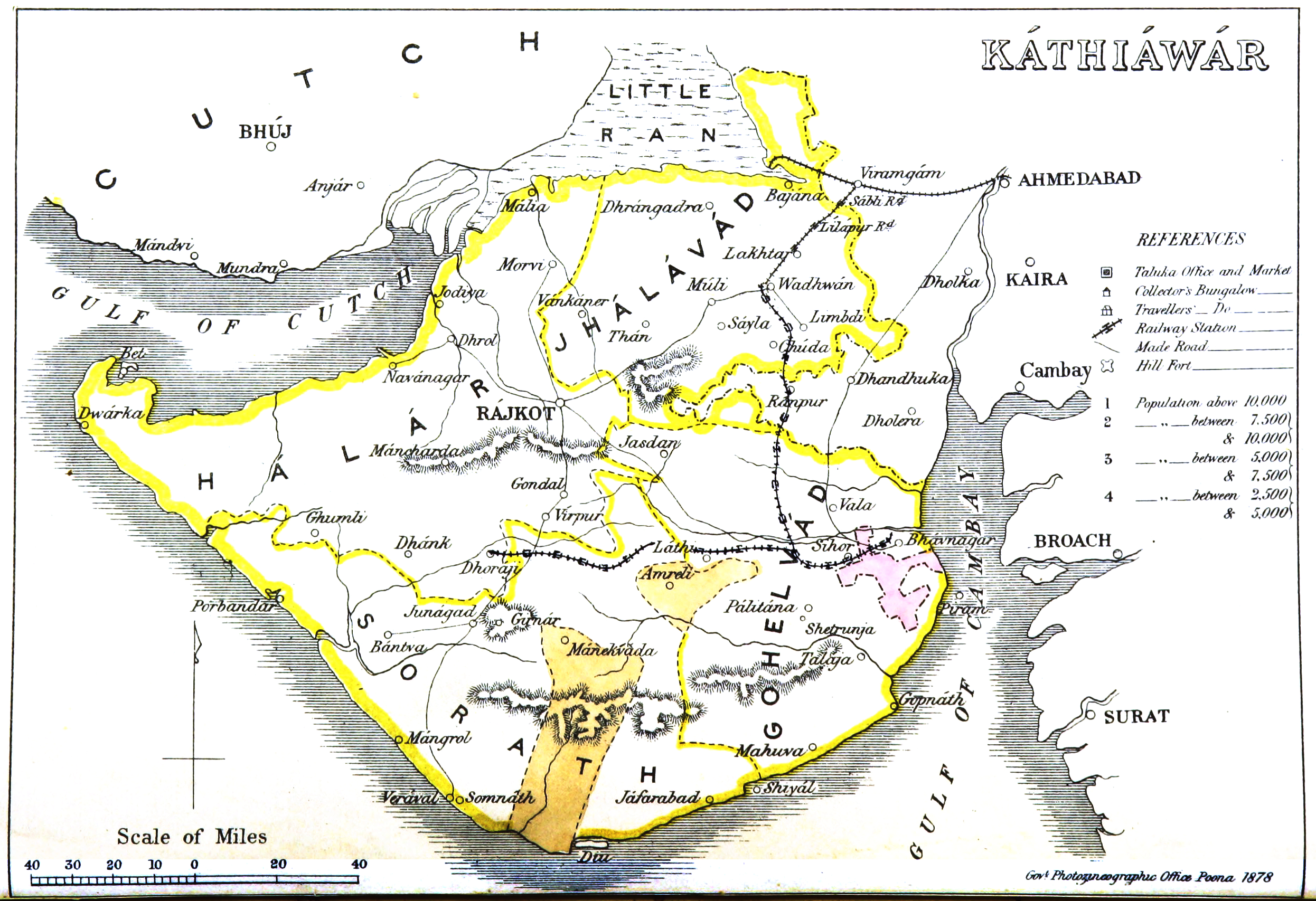
Kathiawar - alternative spelling Kathiwad and Kattywar

Produced by the Government Photographic Department, Poona dated 1878. Available at Wikimedia “Kathiawar Map, 1878”

Reproduced from the “History of Kathiawad” by Capt H Wilberforce-Bell; published by William Heinmann, London, 1916. pdf version [1] Map on page 371 (pdf 392 of 394)
Kathiawar is a peninsula, originally known as Saurastra. In the 18th Century the name was changed to Kathiawar and today forms part of the Indian State of Gujarat.
The peninsula covers an area of 23,345 sq. miles (60,720 sq. Km) and in 1901 had a population of 2,645,805[1]. Most of the area was under the jurisdiction of the Government of India, and also Portugal had the island colony of Diu on the peninsular which covered 20 sq. miles (51.8sq. Km) with a population of 14,614 [2].
In 1807 the Kathiawar peninsular came under British Influence with removal of the Arab forces who annualy maraudered the area, an agreement with the local Families regulating their finances, liquidation of old debts and the reforms forming the foundation to the stability of the area were put in place by Lieutenant-Colonel Walker the first Resident in the form of The Settlement (a form of treaty) [3].
Kathiawar by the late 1800’s was governed by 193 small Princely States, ruled by local potentates who acknowledged British control in return for local sovereignty. These States comprised the ‘Kathiawar Agency’. The rest of the peninsula, chiefly in the east along the Gulf of Cambay, were districts ruled directly by the British as part of British India's Bombay Presidency, which included part of the peninsula [4].
The ‘Kathiawar Agency’ was a political unit formed in 1822 with headquarters at Rajkot, the town where the British Political Agent used to reside. He reported to the Political Department office at Bombay [5]. The area was divided the area into four regions these being Halar, Jhalavad, Sorath and Gohelvad [1].
Historical books online
Further Information
See also page Kathiawar Peninsula Railway and Tramway Systems
References
- ↑ 1.0 1.1 “Imperial Gazette of India” Vol.15. p.164; Retrieved 10 Jun 2017
- ↑ “Imperial Gazette of India” Vol.11. p.362-364; Retrieved 10 Jun 2017
- ↑ Google Books "Parliamentary Papers 1780-1849" page 114; Retrieved 10 Jun 2017
- ↑ Wikipedia “Kathiawar”; Retrieved 10 Jun 2017
- ↑ Wikipedia “Kathiawar Agency”; Retrieved 10 Jun 2017