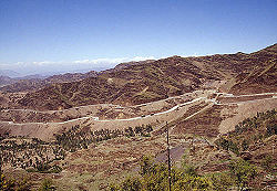
Khyber Pass
Jump to navigation
Jump to search
| Khyber Pass | |
|---|---|

| |
| Presidency: Bengal | |
| Coordinates: | 34.102179°N 71.121968°E |
| Altitude: | |
| Present Day Details | |
| Place Name: | Khyber Pass |
| State/Province: | Federally Administered Tribal Areas (FATA) |
| Country: | Pakistan |
| Transport links | |
Alternative spelling: Khaibar Pass, Khaiber Pass
The Khyber Pass connects the Pakistani province of NWFP to Afghanistan. It is currently part of Khyber Agency in the Federally Administered Tribal Areas (FATA) of Pakistan.
Contents
History
Also see
Locations within the Pass
- Ali Masjid
- Jamrud
- Landi Kotal
- The border crossing with Afghanistan is at Torkhum (Wikipedia)
Cemeteries
- Ali Masjid
- Landi Kotal
Forts
External links
- Khyber Pass Wikipedia
- Khyber Pass: Town & Places kp.gov.pk
- "Construction of Roads and Railways in the Khyber Pass during the British period: A Positive Side-Effect of British Colonial Rule" by Javed Iqbal Central Asia Journal No. 61 [c 2007?] University of Peshawar, now archived.
- Photo Gallery www.world66.com
- View Of The Khyber Pass From Shagai Fort from the second album of Private J W Linley of the 2nd Battalion, The Northamptonshire Regiment compiled whilst serving in India 1923-1938. flickr.com
- Postcard of Shagai Fort with the Khyber Hills in the background NWFP mattoid.com
- Photographs taken in the 1920s from the Lynch Album, British Museum. The photographer was Hugh Dermot Lynch who served with the North Western Railway as a Transportation Officer. Click on the images to enlarge.
- Shagai Fort in the Khyber Pass
- The army camp at Landi Kotal
- Landi Khana 1 Photograph of the railway station, army camp and the road to Kabul.
- Landi Khana 2 Photograph of the Gurkha camp and railway station at Landi Khana.
- From a collection of postcards at the ETH-Bibliothek Zürich, sent by F.G. Prew, a soldier, probably in the 2nd Battalion, Essex Regiment to Adolf Feller of Switzerland.
- The boundary between the Afghan & British territory on the NW Frontier, (but not a border crossing point), post marked 1928 Landi Kotal with reverse side
- The Boundary Line [border crossing point] between British and Afghan Territory on the Border of Frontier NWFP, post stamped 14.7.1930, Nowshera with message “The native sentry on duty will let no one pass beyond this board without a passport”.
- Frontier of India 1946 Captioned " Photo taken by my Grandfather, James Wilson, serving with the Royal Artillery in India during WW2". 500px.com.
- Photograph : Kyber Pass 1940s from the collection of James Wilson, Royal Artillery. 500px.com.
- Roving Report: North Western Frontier (2) YouTube video, taken c 1960? in the vicinity of the Khyber Pass. Includes images of British regimental crests carved in the rock face.
- 2007 photograph of regimental plaques, Khyber Pass by Valerie Cliff www.25thlondon.com
- Bibliography: Publications on the Khyber maverickpakistanis.com, now archived.
Historical books online
- The Khyber by Edward A. Morphy. 1899 Full title: The Khyber: a Sketch of the Pass, its Establishment, Physical Features and Recent History …and some Hints to Travellers. Archive.org, Digital Library of India Collection
- Khyber page 227 North-West Frontier Province, Imperial Gazetteer of India Provincial Series 1908 Archive.org
- "Chapter IV Khyber and Beyond" page 69 Khyber Caravan: Through Kashmir, Waziristan, Afghanistan, Baluchistan and Northern India] by Gordon Sinclair 1936. Archive.org. Also available PAHAR Mountains of Central Asia Digital Dataset. If download button does not display, locate in Books/Indian Subcontinent/1936. Gordon Sinclair (Wikipedia), Canadian journalist.
- Permanent Way Through the Khyber by Victor Bayley 1939, first published 1934. Link to a pdf download PAHAR Mountains of Central Asia Digital Dataset. Also see Khyber Railway.