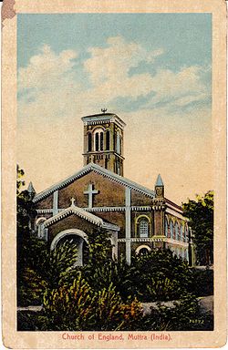
Muttra
Jump to navigation
Jump to search
| Muttra | |
|---|---|

| |
| Presidency: Bengal | |
| Coordinates: | 27.492739°N 77.666121°E |
| Altitude: | 174 metres (570 feet) |
| Present Day Details | |
| Place Name: | Mathura |
| State/Province: | Uttar Pradesh |
| Country: | India |
| Transport links | |
| Muttra Hathras Provincial Railway Muttra Achnera Provincial State Railway Nagda-Mathura(Muttra) Railway | |
| FibiWiki Maps | |
|---|---|
| See our interactive map of this location showing places of interest during the British period | |
| [xxxxx Muttra] |
Muttra was the headquarters of Muttra District in the Agra Division of United Provinces during the British period. Today it is a city of some 2.5 million people on the right bank of the Jumna in the Indian state of Uttar Pradesh.
A cantonment was established in 1804. The Royal Artillery Training Centre was established in 1935.
Spelling Variants
Modern name: Mathura
Variants: Muttra
External links
- Muttra City Imperial Gazetteer
- Cantt Board Mathura: History A cantonment was established in 1804. The Royal Artillery Training Centre was established in 1935.
- Christ Church, Mathura (Church of North India) Beautiful Indian Churches.
- Muttra Chapel, N.W.P. India. Page 14, 26th October 1878 The Tablet The International Catholic News Weekly, now an archived webpage.
- First page of an article Bridges on the Northern Section of the Nagda-Muttra State Railway by John Kerr Robertson, ICE Minutes of the Proceedings, Volume 193, Issue 1913, 01 January 1913 , pages 331 –346
- The opening of the Nagda-Muttra State Railway to through traffic in October, 1909, marked the completion of an important addition to the railway system of India. Leaving the Godhra-Rutlam Nagda Railway at Nagda, the new railway runs almost due north, through Central India and the Rajputana States, to Muttra, where it forms a junction with the Agra-Delhi chord railway.
- Images of Mathura from Professor Pritchett’s website Indian Routes
- Hog Sticking Raj Style! Part II mentions the Muttra Tent Club.
- Video: The Muttra Cup Meeting India’s Largest Pig-Sticking Contest 1 min 33sec preview British Pathe
Historical books online
- Muttra page 469 The Bengal and Agra Annual Guide and Gazetteer for 1842 Volume II Google Books
- Muttra page 543 The Baptist Magazine for 1843 Google Books
- Muttra page 373 Report of the Commissioners Appointed to Inquire into the Sanitary State of the Army in India : with Abstract of Evidence, and of Reports Received from Indian Military Stations 1864 Archive.org
- Mathura; a District Memoir by Frederic Salmon Growse, 1883 Archive.org
- Chapter VII "The City of Mathura: The European Institutions and Museum" page 159. Includes a photograph of the Sacred Heart Catholic Church
- Report on the Settlement of the Muttra District, North-Western Provinces (1879) by R. S. Whiteway Bengal Civil Service 1879 Archive.org
- Transcription of Mathura: A Gazetteer, edited and compiled by D.L. Drake-Brockman 1911 brajdiscovery.org
- The Personal Adventures and Experiences of a Magistrate During the Rise, Progress, and Suppression of the Indian Mutiny by Mark Thornhill 1884 Archive.org. Also available as a current reprint by Cambridge University Press Preview Google Books. The author was the Magistrate at Muttra.
- "An Indian Incident" page 18 The Wooden City; a Journal for British Prisoners of War. 1915 Archive.org. A Shikar expedition from Muttra in 1907.