Difference between revisions of "Rangoon"
(→Maps) |
(→Historical books online) |
||
| Line 64: | Line 64: | ||
*[http://seasiavisions.library.cornell.edu/bookreader/sea:282/#page/179/mode/1up "Rangoon"] page 145 ''Wanderings in Burma'' by George W Bird 1897 “South East Asia Visions” Cornell University with | *[http://seasiavisions.library.cornell.edu/bookreader/sea:282/#page/179/mode/1up "Rangoon"] page 145 ''Wanderings in Burma'' by George W Bird 1897 “South East Asia Visions” Cornell University with | ||
**[http://seasiavisions.library.cornell.edu/bookreader/sea:282/#page/177/mode/1up Map of Rangoon Town and Suburbs] | **[http://seasiavisions.library.cornell.edu/bookreader/sea:282/#page/177/mode/1up Map of Rangoon Town and Suburbs] | ||
| + | *[https://archive.org/details/cu31924023503174 ''Scenes in Burma: An Album of 125 Views''] c 1900-1910? Archive.org. Contains many photographs of Rangoon, including churches. | ||
== References == | == References == | ||
Revision as of 11:22, 29 December 2014
| Rangoon | |
|---|---|

| |
| Presidency: Bengal Presidency | |
| Coordinates: | 16.868878°N 96.236255°E |
| Altitude: | 26m (85 ft) |
| Present Day Details | |
| Place Name: | Yangon |
| State/Province: | Yangon Division |
| Country: | Burma |
| Transport links | |
| FibiWiki Maps | |
|---|---|
| See our interactive map of this location showing places of interest during the British period | |
| [xxxxx Rangoon] |
Rangoon, in what was formerly known as Lower Burma, was the capital of British Burma from 1885 and a separate district in Pegu Division during the British period. It was also the headquarters of Hanthawaddy District.
Contents
History
Rangoon came under British rule in the 1850s and was transformed into a busy commercial port. It became the capital of British Burma after Upper Burma was captured in the 3rd Burma War, making overland access from the rest of British India possible.
Military history
- Occupation of Rangoon 1824, part of the 1st Burma War
- Battle of Rangoon 1852, part of the 2nd Burma War
There was a cantonment at Rangoon. C 1927 a new cantonment was built at Mingaladon, twelve miles to the north of Rangoon, although some regiments remained in Rangoon. During the Second World War, Mingaladon was the location of an RAF base, which is now the Rangoon international airport.
Spelling Variants
Modern name: Yangon
Variants: Rangoon
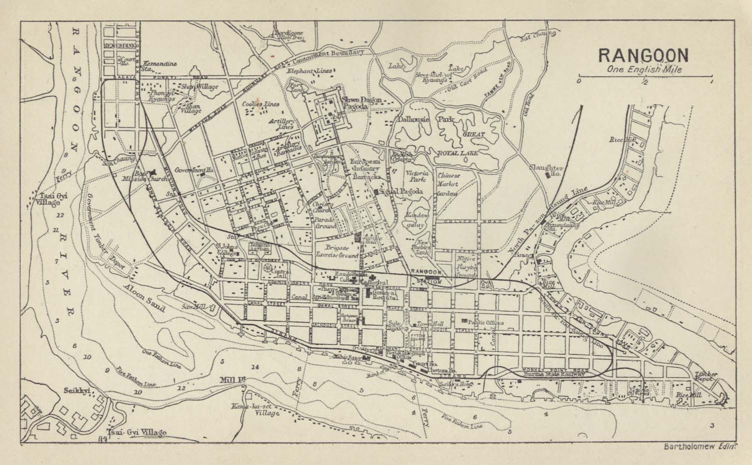
Maps
- Map of Rangoon 1893 Ian Poyntz’ Rootsweb Historical Maps of India
- Map of Rangoon 1909 Imperial Gazetteer of India
- Map of Rangoon 1912 Historical Maps of Asia Collection, University of Texas, Austin
- Map of Rangoon 1924 Ian Poyntz’ Rootsweb Historical Maps of India
- Map of Rangoon 1931 Imperial Gazetteer of India
- The Anglo -Burmese Library includes at least one historical map of Rangoon which can be increased to show great detail, available in the members' area.
Cemeteries
- The English Cantonment Cemetery, Rangoon (Scroll down to near the bottom of the page) from Steve Fogden’s “ Chindit Chasing, Operation Longcloth 1943”
- Rangoon War Cemetery
- Rangoon War Cemetery Roll of Honour roll-of-honour.org.uk
- Rangoon War Cemetery Scroll down for photographs and cemetery information from Steve Fogden’s “ Chindit Chasing, Operation Longcloth 1943”
- WW2Talk post CWGC Rangoon Memorial (Burma) 2010: Pics of all c27,000 names now available. A free offer.
- Taukkyan War Cemetery including the Rangoon Memorial
- Taukkyan War Cemetery and the Rangoon Memorialfrom above mentioned website of Steve Fogden
- Roll of Honour Taukkyan Memorial Roll-of-honour.org.uk
- Taukkyan War Cemetery cwgc.org
- The Armenian Cemetery in Rangoon has been completely demolished. [1]
External links
- Rangoon City Imperial Gazetteer
- Photograph: View of the Cantonment, Rangoon 1855 by Linnaeus Tripe. Click to enlarge. British Library
- Holy Trinity Cathedral - Rangoon – 1886 flickr.com
- Photograph Album: Rangoon by DBHKer flick.com. Includes churches
- Photographs of colonial buildings in Yangon taken mid 2012 from the website of photographers Jacques Maudy and Jimi Casaccia with the article Burma: Visionary Photographers Train Cameras On Yangon’s Colonial Buildings Eurasia Review August 2, 2012
- A Fading Yangon Captured in Photos with a Slideshow September 13, 2012 Wall Street Journal Life and Style: Scene Asia
- "A toast to the past" [The Pegu Club] by Wade Guyitt 08 July 2013 Myanmar Times. Retrieved 30 August 2014
- Chasing Chinthes Armenians in Rangoon (retrieved 27 May 2014)
- "The last Armenians of Myanmar" by Andrew Whitehead 27 August 2014 bbc.com. Retrieved 1 September 2014
- New Cantonment, Mingaladon. Hansard 28 July 1927. Retrieved 28 August 2014.
- RAF Mingaladon rafweb.org. Retrieved 28 August 2014.
- Yangon [Anglican Archdiocese] Anglican Communion. Retrieved 28 October 2014
- Roman Catholic Archdiocese of Yangon. Retrieved 28 October 2014
Historical books online
- "Rangoon" page 145 Wanderings in Burma by George W Bird 1897 “South East Asia Visions” Cornell University with
- Scenes in Burma: An Album of 125 Views c 1900-1910? Archive.org. Contains many photographs of Rangoon, including churches.
References
- ↑ WW2Talk Forum thread Father and Uncle in Indian Army-how to research? which includes a section of a map showing the location of the cemetery, the latter only viewable by logged in members of WW2Talk Forum) (retrieved 27 May 2014)