State of Phulra
Jump to navigation
Jump to search
| State of Phulra | |
|---|---|

| |
| Presidency: | |
| Coordinates: | |
| Altitude: | |
| Present Day Details | |
| Place Name: | Phulra Union Council |
| State/Province: | North West Frontier Province, (NWFP), now Khyber Pakhtunkhwa |
| Country: | Pakistan |
| Transport links | |
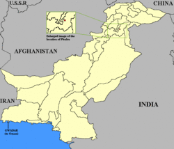
Phulra was a minor state or Jagir estate, total area approx 82 sq kms, under the vassalage of Amb State. Its status remained disputed until 1947, when India and Pakistan became independent from British Rule. In 1950, Phulra was absorbed into Mansehra area of Hazara, NWFP, Pakistan.
Location
Located in the Hazara region, close to former Amb State, now a minor union council, part of Oghi tehsil of Mansehra district.
List of rulers
The rulers or Khans of Phulra were:
- Madad Khan (1828-1857)
- Abdullah Khan (1858, confirmed as Khan of Phulra- 1890)
- Abdur Rahman Khan (1890-1908)
- Ata Muhammad Khan (1908-1932)
- Abdul Latif Khan (1932-1950)
- 1950--Phulra abolished