File:Bombay Tram Stations.png
Summary
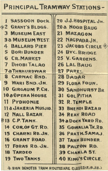
The original map ’Bombay City’, published in 1958 as a tourist map from Joshi & Co, Bombay, shows the location of the tramway stops. The map has been used by Harvard University as a Humanities Project which includes the city of Mumbai. Harvard University, “Humanities 54: The Urban Imagination / Mubbai”. Editiors - Julie Buckler, Samuel Hazzard Cross Professor of Slavic and Comparative Literatures, 2015-16.
Fibis have taken this map and marked in purple the tram routes and entered the tram stop numbers in Red corresponding to the list of tram shops shown on the map.
Licensing
|
|
This work is licensed under the Creative Commons Attribution 3.0 unported License. Specific Attribution: None specified Anyone may use this image for any purpose provided it is attributed as specified. |

File history
Click on a date/time to view the file as it appeared at that time.
| Date/Time | Thumbnail | Dimensions | User | Comment | |
|---|---|---|---|---|---|
| current | 13:21, 12 October 2020 | | 371 × 585 (468 KB) | PEA-2292 (talk | contribs) | The original map ’Bombay City’, published in 1958 as a tourist map from Joshi & Co, Bombay, shows the location of the tramway stops. The map has been used by Harvard University as a Humanities Project which includes the city of Mumbai <ref>[https:... |
- You cannot overwrite this file.
File usage
The following page uses this file: