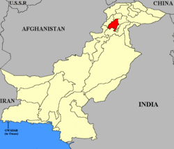
Swat State: Difference between revisions
Jump to navigation
Jump to search
Symorsebrown (talk | contribs) Add external links |
wikify |
||
| (One intermediate revision by one other user not shown) | |||
| Line 4: | Line 4: | ||
|coordinates= | |coordinates= | ||
|altitude= | |altitude= | ||
|presentname= Swat | |presentname= [http://en.wikipedia.org/wiki/Swat,_Pakistan Swat District]; [http://en.wikipedia.org/wiki/Shangla_District Shangla District] | ||
|stateprovince= [ | |stateprovince= [http://en.wikipedia.org/wiki/North-West_Frontier_Province Khyber-Pakhtunkhwa] | ||
|country= Pakistan | |country= [http://en.wikipedia.org/wiki/Pakistan Pakistan] | ||
}} | }} | ||
| Line 18: | Line 18: | ||
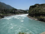
[[Image:Swat_river_nwfp.JPG|thumb|150px|Swat River]] | [[Image:Swat_river_nwfp.JPG|thumb|150px|Swat River]] | ||
The River Swat flows through it. | The River Swat flows through it. | ||
== External Links == | == External Links == | ||
Latest revision as of 15:21, 25 April 2010
| Swat State | |
|---|---|

| |
| Presidency: | |
| Coordinates: | |
| Altitude: | |
| Present Day Details | |
| Place Name: | Swat District; Shangla District |
| State/Province: | Khyber-Pakhtunkhwa |
| Country: | Pakistan |
| Transport links | |
Capital
History
It was ruled by a Wali until 1969 when it merged with Pakistan.
Geography

The River Swat flows through it.
External Links
Princely State Wikipedia
Historical Books on-line
Swat State Imperial Gazetteer of India 1908