Hyderabad: Difference between revisions
Jump to navigation
Jump to search
m typo |
Symorsebrown (talk | contribs) Add external links |
||
| Line 1: | Line 1: | ||
{{Locations_Infobox | {{Locations_Infobox | ||
|presidency=[[Madras]] | |presidency=[[Madras]] | ||
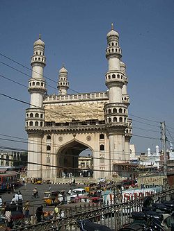
|image= | |image=Charminar Hyderabad.jpg | ||
|coordinates= [http://maps.google.com/maps?ll=17.366,78.476&spn=0.01,0.01&t=m&q=17.366,78.476 | |coordinates= [http://maps.google.com/maps?ll=17.366,78.476&spn=0.01,0.01&t=m&q=17.366,78.476 17.366°N, 78.476°E] | ||
|altitude= 536 m (1,759 ft) | |altitude= 536 m (1,759 ft) | ||
|presentname= Hyderabad | |presentname= [http://en.wikipedia.org/wiki/Hyderabad,_India Hyderabad] | ||
|stateprovince= Andhra Pradesh | |stateprovince= [http://en.wikipedia.org/wiki/Andhra_Pradesh Andhra Pradesh] | ||
|country=India | |country=[http://en.wikipedia.org/wiki/India India] | ||
|transport=[[Nizam's Guaranteed State Railway]] | |transport=[[Nizam's Guaranteed State Railway]] | ||
}} | }} | ||
Revision as of 08:58, 18 September 2010
| Hyderabad | |
|---|---|

| |
| Presidency: Madras | |
| Coordinates: | 17.366°N, 78.476°E |
| Altitude: | 536 m (1,759 ft) |
| Present Day Details | |
| Place Name: | Hyderabad |
| State/Province: | Andhra Pradesh |
| Country: | India |
| Transport links | |
| Nizam's Guaranteed State Railway | |
Not to be confused with Hyderabad, Sind or Hyderabad State.
Hyderabad was the capital of Hyderabad State and the seat of the Nizam. In present day India it is the capital of the state of Andhra Pradesh and has effectively merged with the smaller, neighbouring Secunderabad.
Railways
The main station in Hyderabad is Kacheguda; it was built in 1916.
Sources
- "Chronological History of Railways in India" (The IRFCA Server : accessed 01 December 2008).