Maharajpore: Difference between revisions
Jump to navigation
Jump to search
Symorsebrown (talk | contribs) Amend coordinates. |
Symorsebrown (talk | contribs) Add map image |
||
| Line 11: | Line 11: | ||
|transport= | |transport= | ||
}} | }} | ||
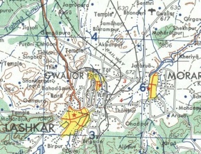
[[Image:Maharajpurmap.jpg|right|thumb|290px|Maharajpur location<br>Survey map 1920-1946]] | |||
The site of the battle was about 5 miles north east of Gwalior Fort near the present day Gwalior Airport. Not to be confused with Maharajpur south east of Jabalpur | The site of the battle was about 5 miles north east of Gwalior Fort near the present day Gwalior Airport. Not to be confused with Maharajpur south east of Jabalpur | ||
== MIlitary history == | == MIlitary history == | ||
Revision as of 17:27, 1 November 2011
| Maharajpore | |
|---|---|
| [[Image:|250px| ]] | |
| Presidency: Bengal | |
| Coordinates: | 26.268065°N 78.249064°E |
| Altitude: | |
| Present Day Details | |
| Place Name: | Maharajpur |
| State/Province: | Madhya Pradesh |
| Country: | India |
| Transport links | |

Survey map 1920-1946
The site of the battle was about 5 miles north east of Gwalior Fort near the present day Gwalior Airport. Not to be confused with Maharajpur south east of Jabalpur
MIlitary history
Spelling Variants
Modern name: Maharajpur
Variants: Maharajpore/Maharajpoor