Ranikhet: Difference between revisions
Jump to navigation
Jump to search
No edit summary |
Symorsebrown (talk | contribs) m Layout |
||
| Line 8: | Line 8: | ||
|country= [http://en.wikipedia.org/wiki/India India] | |country= [http://en.wikipedia.org/wiki/India India] | ||
}} | }} | ||
[[File:Station Dairy Ranikhet.jpg|thumb|Right|Station Dairy at Ranikhet]]<br /> | |||
[[Ranikhet]] is an important military hill station. | [[Ranikhet]] is an important military hill station. | ||
==External links== | ==External links== | ||
| Line 19: | Line 17: | ||
*[http://www.jimcorbettnationalpark.com/ranikhet-camp-india.asp Ranikhet in the Himalayas] | *[http://www.jimcorbettnationalpark.com/ranikhet-camp-india.asp Ranikhet in the Himalayas] | ||
*[http://www.holmfarmranikhet.com/story.HTM Holm Farm, Ranikhet] | *[http://www.holmfarmranikhet.com/story.HTM Holm Farm, Ranikhet] | ||
[[Category:Cities, towns and villages in Bengal Presidency]] | [[Category:Cities, towns and villages in Bengal Presidency]] | ||
[[Category:Locations]] | [[Category:Locations]] | ||
[[Category:Hill Stations]] | [[Category:Hill Stations]] | ||
Revision as of 15:10, 8 February 2012
| Ranikhet | |
|---|---|

| |
| Presidency: Bengal | |
| Coordinates: | 29.65°N 79.42°E |
| Altitude: | 1,869 m (6,132 ft) |
| Present Day Details | |
| Place Name: | Ranikhet |
| State/Province: | Uttarakhand |
| Country: | India |
| Transport links | |

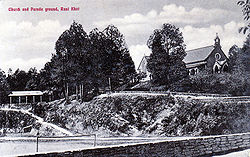
Ranikhet is an important military hill station.
External links
- Ranikhet Wikipedia
- Ranikhet Revisted Article dated 28 May 1989 by Gitanjali Prasad
- Ranikhet in the Himalayas
- Holm Farm, Ranikhet