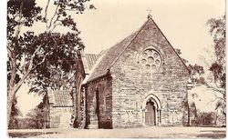
Pachmarhi: Difference between revisions
Jump to navigation
Jump to search
No edit summary |
|||
| Line 17: | Line 17: | ||
==External Links== | ==External Links== | ||
[http://dsal.uchicago.edu/reference/gazetteer/pager.html?objectid=DS405.1.I34_V19_313.gif Pachmarhi] Imperial Gazetteer of India | *[http://dsal.uchicago.edu/reference/gazetteer/pager.html?objectid=DS405.1.I34_V19_313.gif Pachmarhi] Imperial Gazetteer of India | ||
*[https://www.flickr.com/photos/petergriffin/114727093/in/gallery-23268776@N03-72157629054551929/ Photograph: Christ Church, Pachmarhi, 2004] by Peter Griffin flickr.com | |||
== References == | == References == | ||
Revision as of 08:17, 29 November 2014
| Pachmarhi | |
|---|---|

| |
| Presidency: Bengal | |
| Coordinates: | 22.4667°N 78.4333°E |
| Altitude: | 1,015 metres (3,330 ft) |
| Present Day Details | |
| Place Name: | Pachmarhi |
| State/Province: | Madhya Pradesh |
| Country: | India |
| Transport links | |
Pachmarhi was a hill station and the summer capital for the Central Provinces.
There was an Army School of Musketry at Pachmarhi (in May 1915)[1]
Related Articles
External Links
- Pachmarhi Imperial Gazetteer of India
- Photograph: Christ Church, Pachmarhi, 2004 by Peter Griffin flickr.com
References
- ↑ Fielding, Simon 14th Hussars Officer writes home from Mesopotamia Great War Forum 25 November 2014. Retrieved 25 November 2014.