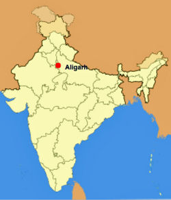
Aligarh: Difference between revisions
Symorsebrown (talk | contribs) m Typo |
+cat |
||
| Line 10: | Line 10: | ||
}} | }} | ||
'''Aligarh''', also known as Koil, is situated about 75 miles south-east of [[Delhi]] | '''Aligarh''', also known as Koil, is situated about 75 miles south-east of [[Delhi]]. | ||
Aligarh's Civil Station lies north-east of the city. The old cantonment was abolished in 1869 and the old cemetery from 1802 is near the fort. | Aligarh's Civil Station lies north-east of the city. The old cantonment was abolished in 1869 and the old cemetery from 1802 is near the fort. | ||
Aligarh | == Spelling Variants == | ||
Modern name: Aligarh<br> | |||
Variants: Alighur/Aligurh/Allygurh/Alliegurh | |||
== History == | == History == | ||
[[Battle of Alighur]] 1803<br>[[Battle of Allygurh August 1857]]<br>[[Battle of Allygurh October 1857]] | [[Battle of Alighur]] 1803<br>[[Battle of Allygurh August 1857]]<br>[[Battle of Allygurh October 1857]] | ||
==Railways== | |||
Aligarh was a junction between the main line of the [[East Indian Railway]] and a branch of the [[Oudh and Rohilkhand Railway]]. | |||
== Murrays Handbook 1933 == | == Murrays Handbook 1933 == | ||
Murrays 1933 Handbook lists the following for Aligarh: | Murrays 1933 Handbook lists the following for Aligarh: | ||
| Line 24: | Line 31: | ||
'''Missions:''' American Methodist Episcopal, R.C., and C.M.S. Church <br> | '''Missions:''' American Methodist Episcopal, R.C., and C.M.S. Church <br> | ||
'''Petrol Stores and Motor Accessories:''' Edulji Bottlewala, Railway Road <br> | '''Petrol Stores and Motor Accessories:''' Edulji Bottlewala, Railway Road <br> | ||
== External Links == | == External Links == | ||
[http://www.1911encyclopedia.org/Aligarh "Aligarh"] ''Love to Know 1911''. | [http://www.1911encyclopedia.org/Aligarh "Aligarh"] ''Love to Know 1911''. | ||
| Line 33: | Line 38: | ||
[[Category:Locations]] | [[Category:Locations]] | ||
[[Category:Cities, towns and villages in Bengal Presidency]] | |||
Revision as of 19:53, 26 June 2009
| Aligarh | |
|---|---|

| |
| Presidency: Bengal | |
| Coordinates: | 27.893754°N 78.068142°E |
| Altitude: | 178 m (584 ft) |
| Present Day Details | |
| Place Name: | Aligarh |
| State/Province: | Uttar Pradesh |
| Country: | India |
| Transport links | |
| East Indian Railway Oudh and Rohilkhand Railway | |
Aligarh, also known as Koil, is situated about 75 miles south-east of Delhi.
Aligarh's Civil Station lies north-east of the city. The old cantonment was abolished in 1869 and the old cemetery from 1802 is near the fort.
Spelling Variants
Modern name: Aligarh
Variants: Alighur/Aligurh/Allygurh/Alliegurh
History
Battle of Alighur 1803
Battle of Allygurh August 1857
Battle of Allygurh October 1857
Railways
Aligarh was a junction between the main line of the East Indian Railway and a branch of the Oudh and Rohilkhand Railway.
Murrays Handbook 1933
Murrays 1933 Handbook lists the following for Aligarh:
Dak Bungalow: Kellner's Refreshments and Sleeping Rooms
Bank: Imperial Bank
Missions: American Methodist Episcopal, R.C., and C.M.S. Church
Petrol Stores and Motor Accessories: Edulji Bottlewala, Railway Road
External Links
"Aligarh" Love to Know 1911.
"Aligarh" Wikipedia.