Ahmadnagar: Difference between revisions
Jump to navigation
Jump to search
Symorsebrown (talk | contribs) m Typo |
add image |
||
| Line 1: | Line 1: | ||
{{Locations_Infobox | {{Locations_Infobox | ||
|presidency=Bombay | |presidency=Bombay | ||
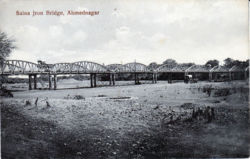
|image= | |image= Saina Iron Bridge Ahmednagar.jpg | ||
|coordinates=[http://maps.google.co.uk/maps?ll=19.095003,74.756679&z=12&t=h&hl=en 19.095003°N 74.756679°E] | |coordinates=[http://maps.google.co.uk/maps?ll=19.095003,74.756679&z=12&t=h&hl=en 19.095003°N 74.756679°E] | ||
|altitude=649 m (2,129 ft) | |altitude=649 m (2,129 ft) | ||
| Line 18: | Line 18: | ||
== Spelling Variants == | == Spelling Variants == | ||
Modern name: | Modern name: Ahmednagar<br> | ||
Variants: Ahmednuggur | Variants: Ahmednuggur | ||
[[Category:Locations]] | [[Category:Locations]] | ||
Revision as of 19:43, 2 April 2010
| Ahmadnagar | |
|---|---|

| |
| Presidency: Bombay | |
| Coordinates: | 19.095003°N 74.756679°E |
| Altitude: | 649 m (2,129 ft) |
| Present Day Details | |
| Place Name: | Ahmednagar |
| State/Province: | Maharashtra |
| Country: | India |
| Transport links | |
| Dhond-Manmad State Railway | |
Ahmadnagar (or Ahmednagar) was a city and district in the Central division of Bombay.
History
Battle of Ahmednuggur 1803
Battle of Ahmednuggur 1804
External links
"Ahmednagar" Love to Know 1911
"Ahmednagar" Wikipedia.
Spelling Variants
Modern name: Ahmednagar
Variants: Ahmednuggur