Jubbulpore: Difference between revisions
Jump to navigation
Jump to search
Symorsebrown (talk | contribs) m Decimal coordinates. |
add image |
||
| Line 2: | Line 2: | ||
{{Locations_Infobox | {{Locations_Infobox | ||
|presidency= [[Bengal]] | |presidency= [[Bengal]] | ||
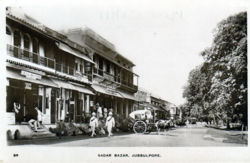
|image= | |image= Sadar Bazar Jubbulpore.jpg | ||
|coordinates=[http://maps.google.co.uk/maps?ll=23.165271,79.945545&z=12&t=h&hl=en 23.16527°N, 79.945545°E] | |coordinates=[http://maps.google.co.uk/maps?ll=23.165271,79.945545&z=12&t=h&hl=en 23.16527°N, 79.945545°E] | ||
|altitude=1,393 m (4,570 ft) | |altitude=1,393 m (4,570 ft) | ||
Revision as of 21:12, 3 April 2010
| Jubbulpore | |
|---|---|

| |
| Presidency: Bengal | |
| Coordinates: | 23.16527°N, 79.945545°E |
| Altitude: | 1,393 m (4,570 ft) |
| Present Day Details | |
| Place Name: | Jabalpur |
| State/Province: | Madhya Pradesh |
| Country: | India |
| Transport links | |
| East Indian Railway Great Indian Peninsula Railway Bengal-Nagpur Railway | |
Also known as Jubbulpur, the town was the meeting point in 1871 for the Great Indian Peninsula Railway (616 miles from Bombay) and the East Indian Railway (220 miles from Allahabad), and the completion of the first Bombay-Calcutta trunk railway line.
External links
"Jubbulpore" Love to Know 1911.
"Jabalpur" Wikipedia.