Montgomery District: Difference between revisions
Jump to navigation
Jump to search
neighbours, subdivisions, cities, reference |
|||
| Line 16: | Line 16: | ||
==Neighbours== | ==Neighbours== | ||
As in 1884. | As in 1884. | ||
North east: [[Lahore District]] | * North east: [[Lahore District]] | ||
North west: [[Jhang District]] | * North west: [[Jhang District]] | ||
South east: River Sutlej which separated it from [[Bahawalpur State]] | * South east: River Sutlej which separated it from [[Bahawalpur State]] | ||
South west: [[Multan District]] | * South west: [[Multan District]] | ||
==District Headquarters== | ==District Headquarters== | ||
Revision as of 10:06, 20 August 2010
| Montgomery District | |
|---|---|

| |
| Presidency: Bengal | |
| Coordinates: | 30.664468°N 73.108496°E |
| Altitude: | |
| Present Day Details | |
| Place Name: | Okara District, Pakpattan District, Sahiwal District |
| State/Province: | Punjab |
| Country: | Pakistan |
| Transport links | |
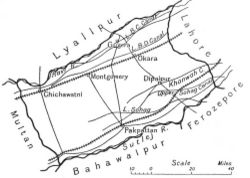
Montgomery District, earlier known as Gugera, was the south-eastermost of the four districts of Multan Division(as in 1884).[1]
Name
It was named after Sir Robert Montgomery, the Lt. Governor of Punjab in 1865. Since 1966, it has been known as Sahiwal District.
Neighbours
As in 1884.
- North east: Lahore District
- North west: Jhang District
- South east: River Sutlej which separated it from Bahawalpur State
- South west: Multan District
District Headquarters
- Gugera: 1852 to 1864
- Montgomery: 1864 - ?
Cities and Towns
- Dipalpur
- Gugera
- Kamalia (aka Kot Kamalia)
- Montgomery (village of Sahiwal before 1865)
- Okara
- Pak Pattan
- Renala Khurd
- Saiyadwala
Subdivisions
There were four tehsils:
- Montgomery
- Gugera
- Dipalpur
- Pak Pattan
Transport
Railways
The Sind, Punjab and Delhi Railway ran through the district. There were stations at: Okara.
Sites of Interest
- Shrine of Baba Farid (Shakar Ganj)
References
- ↑ Gazetteer of the Montgomery District 1883-1884, Govenrment of Punjab, 1884. Reprinted by Sang-e-Meel Publications Lahore, 1990 pg 1
Reading
- Gazetteer of the Montgomery District 1883-1884 Govenrment of Punjab, 1884. Reprinted by Sang-e-Meel Publications Lahore, 1990