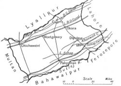
Montgomery District
| Montgomery District | |
|---|---|

| |
| Presidency: Bengal | |
| Coordinates: | 30.664468°N 73.108496°E |
| Altitude: | |
| Present Day Details | |
| Place Name: | Okara District, Pakpattan District, Sahiwal District |
| State/Province: | Punjab |
| Country: | Pakistan |
| Transport links | |
Montgomery District, earlier known as Gugera, was the south-eastermost of the six districts of Multan Division until 1916[1] It was subsequently one of the six districts of Lahore Division.
Name
It was named after Sir Robert Montgomery, the Lt. Governor of Punjab in 1865. Since 1966, it has been known as Sahiwal District.
Neighbours
As in 1884.
- North east: Lahore District
- North west: Jhang District
- South east: River Sutlej which separated it from Bahawalpur State
- South west: Multan District
District Headquarters
- Gugera: 1852 to 1864
- Montgomery: 1864 - ?
Cities and Towns
- Dipalpur
- Gugera
- Kamalia (aka Kot Kamalia)
- Montgomery (village of Sahiwal before 1865)
- Okara
- Pak Pattan
- Renala Khurd
- Saiyadwala
Subdivisions
There were four tehsils:
- Montgomery
- Gugera
- Dipalpur
- Pak Pattan
Transport
Railways
The Sind, Punjab and Delhi Railway ran through the district. There were stations at: Okara.
Sites of Interest
- Shrine of Baba Farid (Shakar Ganj)
References
- ↑ [http://www.gutenberg.org/files/24562/24562-h/24562-h.htm#fig110 The Panjab, North-West Frontier Province and Kashmir," by Sir Hames Douie, Reprinted by Seema Publications, Delhi 1974 pg 263
Reading
- Gazetteer of the Montgomery District 1883-1884 Govenrment of Punjab, 1884. Reprinted by Sang-e-Meel Publications Lahore, 1990