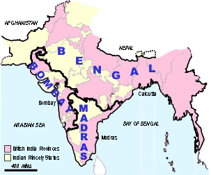
Presidencies
British India was divided into three Presidencies:
- Bombay, which covered the west and north of the country, including what is now Pakistan
- Bengal, which covered the east of the country and included Burma and what is now Bangladesh
- Madras, which covered the southern portion of India
The main cities of the Presidencies were Bombay, Calcutta and Madras, respectively.
Administrative areas of India in the 1930s

Knowing which Presidency a town or city was in, is important when consulting many of the India Office Records held at the British Library.
Also note that administrative boundaries changed from time to time and it is important to check 'border' districts in the adjoining area. The above map is adapted from Plate 21 of the (1931) revised atlas of the Imperial Gazetteer of India. Such small scale maps cannot show every enclave of territory, and this map is not to be taken as an authority for boundaries. For more detail see the provincial maps in the Imperial Gazetteer atlas, and large scale published Survey of India topographical maps.