Howrah
| Howrah | |
|---|---|

| |
| Presidency: Bengal | |
| Coordinates: | 22.59°N, 88.31°E |
| Altitude: | 12 m (39 ft) |
| Present Day Details | |
| Place Name: | Howrah |
| State/Province: | West Bengal |
| Country: | India |
| Transport links | |
| FibiWiki Maps | |
|---|---|
| See our interactive map of this location showing places of interest during the British period | |
| [xxxxx Howrah] |
THIS PAGE IS WAITING FOR MORE DETAILED INFORMATION
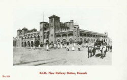
Howrah is situated across the river from Calcutta, on the west bank of the Hugli River. It was the headquarters of Howrah District in the division of the same name in the West Bengal Districts during the British period.
Spelling variants
Modern name: Howrah
Variants: Habara
FIBIS Resources
Churches
- St Thomas Church
Cemeteries
- Bantra Cemetery
- Many maritime related burials took place at Howrah, where St Thomas' Church and Cemetery were established in 1833. See external link below to Bengal Obituary
Howrah Bridge
The Howrah Bridge was designed to link Howrah with the city of Calcutta. The old Floating Pontoon Bridge was built by Sir Bradford Leslie in 1874. It was largely a timber construction which opened to let river traffic through.
In 1937 work began on a new bridge - which is a landmark of Kolkata (Calcutta) today, being one of the foremost cantilever bridges in the world. It was formally opened in 1943 and the old bridge was decommissioned soon after in 1946. The new bridge was renamed Rabindra Setu in 1965 to honour Rabindranath Tagore - the first Indian to win the Nobel Prize for Literature. However, it is still commonly referred to as the Howrah Bridge.
External links
- Howrah City Imperial Gazetteer
- A view of the Howrah Dockyard from the website of the Victoria Memorial Hall, Calcutta
- Cliff's Calcutta: How Richard's singing career actually began in the British Raj by Steve Turner 13 January 2013 dailymail.co.uk. The singer Cliff Richards once lived in Howrah
Historical books online
- Bengal District Gazetteers: Howrah 1909 Archive.org
- List of burials at Howrah (Bengal Obituary) archive.org