File list
Jump to navigation
Jump to search
This special page shows all uploaded files.
| Date | Name | Thumbnail | Size | User | Description |
|---|---|---|---|---|---|
| 15:38, 3 June 2018 | Holkar and Scindia-Neemuch Railway.png (file) |  |
260 KB | PEA-2292 | '''Holkar State Railway''' marked on map in '''Blue''' <br>'''Scindia-Neemuch State Railway''' marked on map in '''Green''' From "Imperial Gazetteer of India, v. 26, Atlas 1909 edition, Railway Map--Sectional (1), p. 23." Extracted from [http://dsal.... |
| 06:36, 30 May 2018 | Mu Valley State Railway.png (file) |  |
186 KB | PEA-2292 | '''Mu Valley State Railway''' Shown in '''Blue''' on Map From "Imperial Gazetteer of India, v. 26, Atlas 1909 edition, Railway Map--Sectional (2), p. 24." Extracted from [http://dsal.uchicago.edu/reference/gaz_atlas_1909/pager.html?object=30 Click h... |
| 06:09, 29 May 2018 | Sittang Valley State Railway.png (file) |  |
187 KB | PEA-2292 | '''Sittang Valley State Railway''' Shown in '''Green''' on Map From "Imperial Gazetteer of India, v. 26, Atlas 1909 edition, Railway Map--Sectional (2), p. 24." Extracted from [http://dsal.uchicago.edu/reference/gaz_atlas_1909/pager.html?object=30 C... |
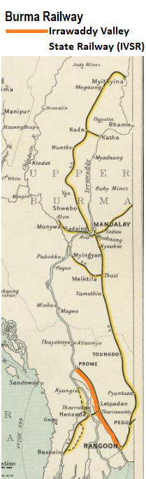
| 06:59, 28 May 2018 | Irrawaddty Valley State Railway.png (file) |  |
187 KB | PEA-2292 | '''Irrawaddy Valley State Railway''' Shown in '''Orange''' on Map From "Imperial Gazetteer of India, v. 26, Atlas 1909 edition, Railway Map--Sectional (2), p. 24." Extracted from [http://dsal.uchicago.edu/reference/gaz_atlas_1909/pager.html?object=3... |
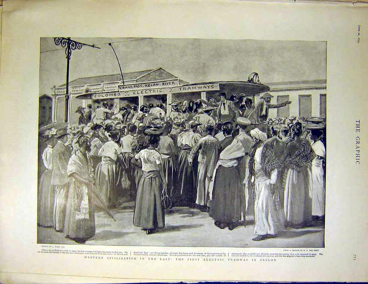
| 06:16, 25 May 2018 | Colombo City Tram c.1899.jpg (file) |  |
127 KB | PEA-2292 | '''Colombo City Tram c.1899' http://www.columbia.edu/itc/mealac/pritchett/00routesdata/1800_1899/dailylife_drawings/ilnviews/tramway1899.jpg Image University of Columbia coolection from the 'The Graphic' , 10 Jun 1899 Note: this is an artists imp... |
| 05:44, 25 May 2018 | Colombo City Tramway.png (file) |  |
7.58 MB | PEA-2292 | '''Colombo City Tramways, Ceylon c.1914''' [https://www.google.co.uk/imgres?imgurl=http%3A%2F%2Flegacy.lib.utexas.edu%2Fmaps%2Fhistorical%2Fbaedeker_indien_1914%2Ftxu-pclmaps-columbo_1914.jpg&imgrefurl=https%3A%2F%2Fwww.lib.utexas.edu%2Fmaps%2Fhistori... |
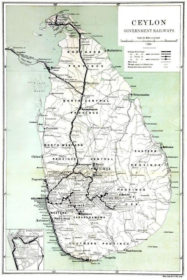
| 04:54, 21 May 2018 | Ceylon Government Railway.png (file) |  |
861 KB | PEA-2292 | '''Ceylon Government Railway 1910''' Map from [https://archive.org/details/cu31924023977659] “The Ceylon Government Railway: A Descriptive and Illustrated Guide”, 1910, by Henry W Cave M.A., FRGS page 15 Category:Railway_maps |
| 13:16, 10 May 2018 | Alexandra Bridge Site 1876.png (file) |  |
86 KB | PEA-2292 | '''Chenab River in vicinity of the Alexandra/Chenab Bridge''' showing 'State of river in 1876' <br>Drawing by courtesy of The Institution of Civil Engineers, London <br>From ''Minutes of Proceedings of Institution of Civil Engineers''Volume 54 Issu... |
| 13:02, 10 May 2018 | Alexandra Bridge v1.png (file) |  |
377 KB | PEA-2292 | '''Alexandra/Chenab Bridge''' From "Imperial Gazetteer of India, v. 26, Atlas 1909 edition, Railway Map--Sectional (1), p. 234." Extracted from [http://dsal.uchicago.edu/reference/gaz_atlas_1909/pager.html?object=29 Click here] and Zoomed using nav... |
| 05:28, 6 May 2018 | Curzon Bridge Fig.3.png (file) |  |
102 KB | PEA-2292 | '''Curzon Bridge, Fig 3''' ‘Elevation of Curzon Bridge Construction’ <br>Drawing by courtesy of The Institution of Civil Engineers, London <br>From ''Minutes of Proceedings of Institution of Civil Engineers'' "The Curzon Bridge at Allahabad" by... |
| 05:24, 6 May 2018 | Curzon Bridge Fig.2.png (file) |  |
93 KB | PEA-2292 | '''Curzon Bridge, Fig 2''' ‘Plan of Curzon Bridge Site’ <br>Drawing by courtesy of The Institution of Civil Engineers, London <br>From ''Minutes of Proceedings of Institution of Civil Engineers'' "The Curzon Bridge at Allahabad" by [[Robert Ric... |
| 16:47, 5 May 2018 | Curzon Bridge Fig.1.png (file) |  |
56 KB | PEA-2292 | '''Curzon Bridge, Fig 1''' ‘Plan of Ganges & Jumna showing cold-weather channels' <br>and 'Plans of river Ganges at bridge site for years 1901-02 through to 1904-05' <br>Drawing by courtesy of The Institution of Civil Engineers, London <br>From ''M... |
| 15:02, 3 May 2018 | Curzon Bridge, Allhahabad, 1905 (Scientific American).png (file) | .png) |
190 KB | PEA-2292 | '''Curzon Bridge, Allhahabad, 1905''' Photograph from the 'Scientific American' Vol 99, Number 13, September 1908 “The narrowing of the Ganges and construction of the Curzon Bridge", page 204, pdf page 4 of 16. Archive.org [[https://ia600803.us.arch... |
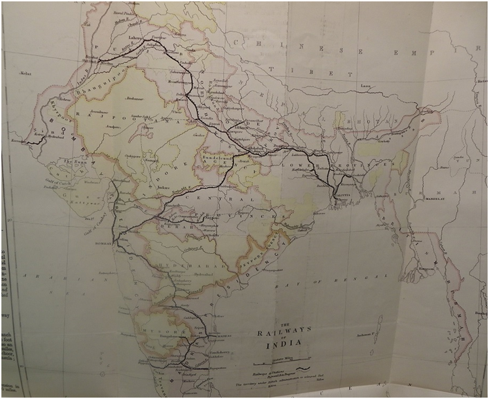
| 04:50, 3 May 2018 | 1870-71 Railway Map from Annual Report.png (file) |  |
684 KB | PEA-2292 | '''1870-71 Railway Map''' The map from this Report has been photographed and reproduced by permission of the British Library. British Library ‘India Office Records L/PARL/2/100 “Railways in India for the year 1870-71” by Juland Danvers , Gover... |
| 15:03, 2 May 2018 | Shoranur-Cochin Railway.png (file) |  |
87 KB | PEA-2292 | '''Shoranur-Cochin Railway''' From "Imperial Gazetteer of India, v. 26, Atlas 1909 edition, Railway Map--Sectional (3), p. 25." Extracted from [http://dsal.uchicago.edu/reference/gaz_atlas_1909/pager.html?object=31 Click here] and Zoomed using naviga... |
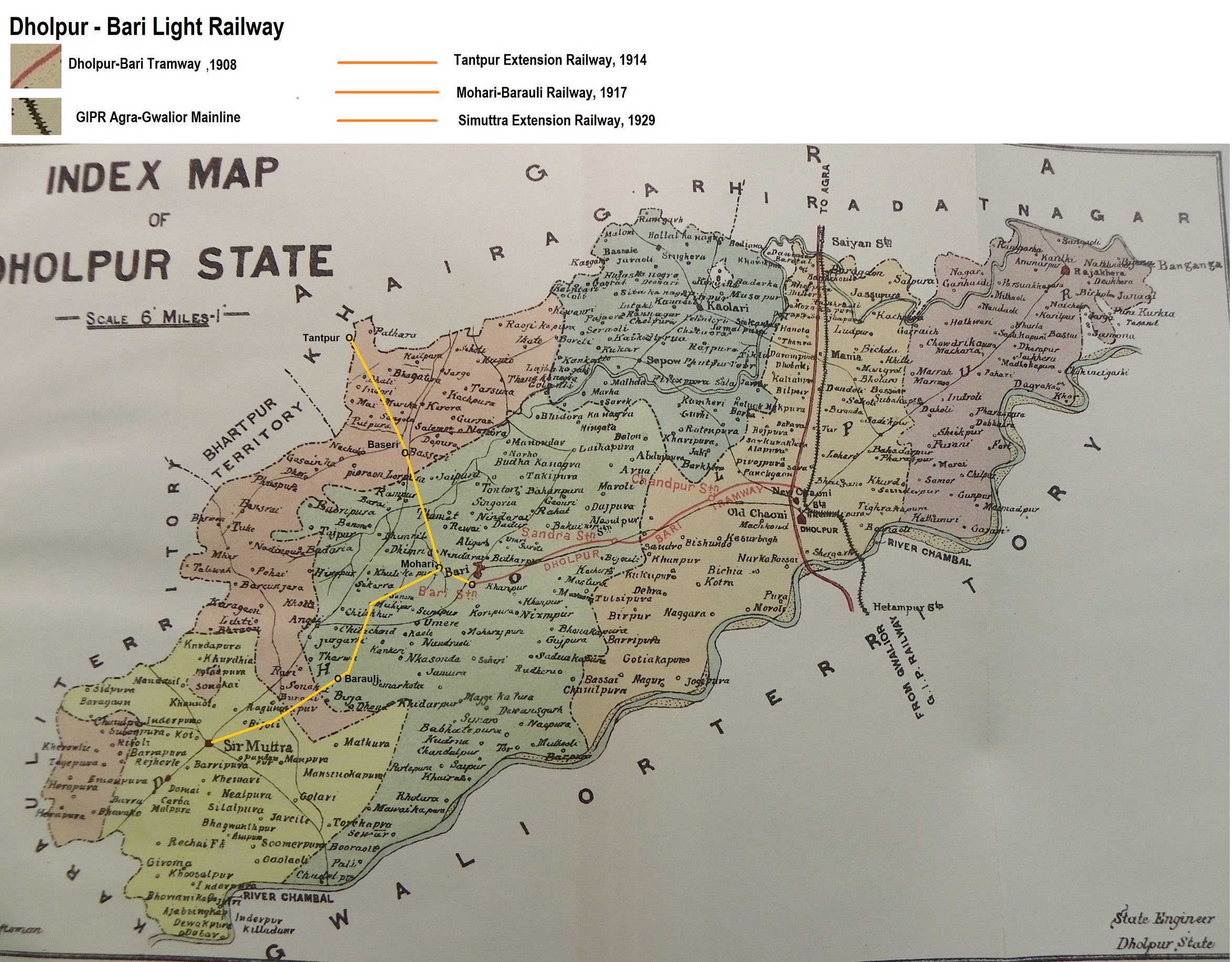
| 13:09, 15 April 2018 | Dholpur-Bari Light Railway.png (file) |  |
6.09 MB | PEA-2292 | ''Dholpur-Bari Light Railway''' Map from British Library IOR/V/10/1102 “Annual Administration Report of Dholpur State for Year ending 30 Sept 1910”. Photographed with permission from the 'Railway Section' of the above report. Marked up with rout... |
| 06:58, 14 April 2018 | Dholpur State Map, 1910.png (file) |  |
549 KB | PEA-2292 | '''Dholpur State Map, 1910''' British Library ‘India Office Records’ IOR/V/10/1102 “Annual Administration Report of Dholpur State for Year ending 30 Sept 1910” Photographed with permission from the 'Railway Section' of the above report. The... |
| 13:54, 11 April 2018 | Cochin State Forest Tramway.png (file) |  |
196 KB | PEA-2292 | '''Cochin State Forest Tramway''' From "Imperial Gazetteer of India, v. 26, Atlas 1909 edition, Railway Map--Sectional (1), p. 23." Extracted from [http://dsal.uchicago.edu/reference/gaz_atlas_1909/pager.html?object=29 Click here] and Zoomed using na... |
| 17:15, 2 April 2018 | Holkar State Railway (Indore State Railway).png (file) | .png) |
261 KB | PEA-2292 | '''Holkar State Railway (Indore State railway)''' From "Imperial Gazetteer of India, v. 26, Atlas 1909 edition, Railway Map--Sectional (1), p. 23." Extracted from [http://dsal.uchicago.edu/reference/gaz_atlas_1909/pager.html?object=29 Click here] a... |
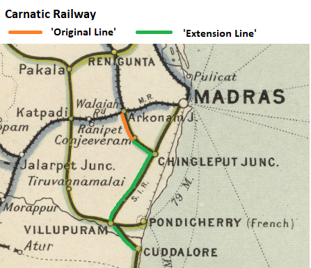
| 13:05, 31 March 2018 | Carnatic Railway.png (file) |  |
253 KB | PEA-2292 | '''Carnatic Railway''' From "Imperial Gazetteer of India, v. 26, Atlas 1909 edition, Railway Map--Sectional (3), p. 25." Extracted from [http://dsal.uchicago.edu/reference/gaz_atlas_1909/pager.html?object=31 Click here] and Zoomed using navigation wi... |
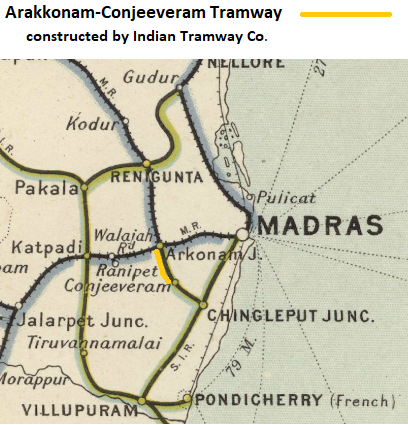
| 05:01, 29 March 2018 | Arakkonam-Conjeeveram Tramway.png (file) |  |
294 KB | PEA-2292 | '''Arakkonam-Conjeeveram Tramway''' From "Imperial Gazetteer of India, v. 26, Atlas 1909 edition, Railway Map--Sectional (3), p. 25." Extracted from [http://dsal.uchicago.edu/reference/gaz_atlas_1909/pager.html?object=31 Click here] and Zoomed using... |
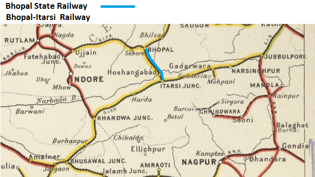
| 10:07, 24 March 2018 | Bhopal-Itarsi Railway.png (file) |  |
353 KB | PEA-2292 | '''Bhopal State Railway''' and ''' Bhopal-Itarsi Railway''' From "Imperial Gazetteer of India, v. 26, Atlas 1909 edition, Railway Map--Sectional (1), p. 23." Extracted from [http://dsal.uchicago.edu/reference/gaz_atlas_1909/pager.html?object=29 Cli... |
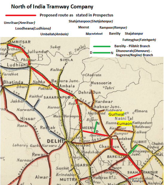
| 16:56, 11 March 2018 | North of India Tramway Proposed Lines.png (file) |  |
470 KB | PEA-2292 | '''North of India Tramway - Proposed Route''' From "Imperial Gazetteer of India, v. 26, Atlas 1909 edition, Railway Map--Sectional (1), p. 23." Extracted from [http://dsal.uchicago.edu/reference/gaz_atlas_1909/pager.html?object=29 Click here] and Zoo... |
| 07:21, 22 February 2018 | Scinde Railway Company - Lines.png (file) |  |
761 KB | PEA-2292 | '''Scinde Railway Company''' From "Imperial Gazetteer of India, v. 26, Atlas 1909 edition, Railway Map--Sectional (1), p. 23." Extracted from [http://dsal.uchicago.edu/reference/gaz_atlas_1909/pager.html?object=29 Click here] and Zoomed using naviga... |
| 13:35, 19 February 2018 | Sindia State Railway.png (file) |  |
146 KB | PEA-2292 | '''Sindia State Railway''' From "Imperial Gazetteer of India, v. 26, Atlas 1909 edition, Railway Map--Sectional (1), p. 23." Extracted from [http://dsal.uchicago.edu/reference/gaz_atlas_1909/pager.html?object=290 Click here] and Zoomed using navigatio... |
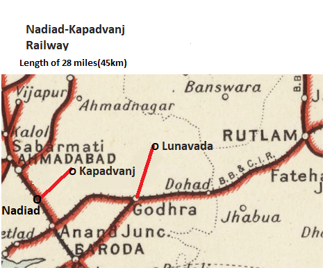
| 11:10, 16 February 2018 | Nadiad-Kapadvanj Railway Map.png (file) |  |
224 KB | PEA-2292 | '''Nadiad-Kapadvanj Railway''' From "Imperial Gazetteer of India, v. 26, Atlas 1909 edition, Railway Map--Sectional (1), p. 23." Extracted from [http://dsal.uchicago.edu/reference/gaz_atlas_1909/pager.html?object=29 Click here] and Zoomed using navig... |
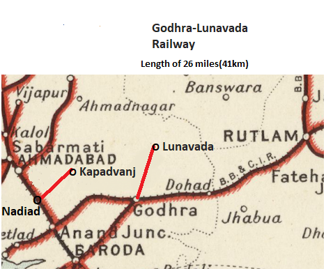
| 07:13, 16 February 2018 | Godhra-Lunavada Railway Map.png (file) |  |
206 KB | PEA-2292 | '''Godhra-Lunavada Railway''' From "Imperial Gazetteer of India, v. 26, Atlas 1909 edition, Railway Map--Sectional (1), p. 23." Extracted from [http://dsal.uchicago.edu/reference/gaz_atlas_1909/pager.html?object=29 Click here] and Zoomed using naviga... |
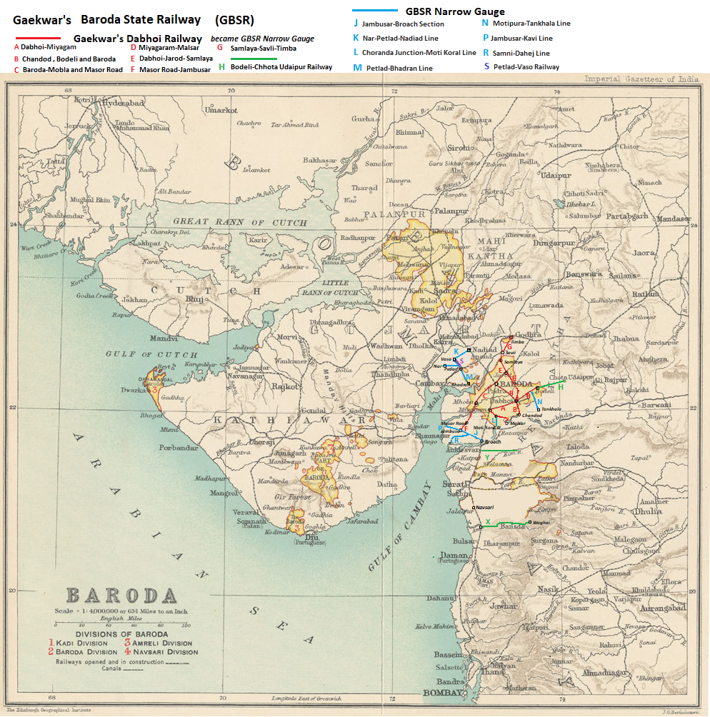
| 16:01, 13 February 2018 | Gaekwar's Baroda State Railway Routes.png (file) |  |
1.55 MB | PEA-2292 | '''Gaekwar's Baroda State Railway''' routes from 1921 (including the Gaekwar's Dabhoi Railway Routes pre-1921) From "Imperial Gazetteer of India, v. 7, Atlas 1909 edition, "Baroda State Map", p. 64." Extracted and Zoomed using navigation window with... |
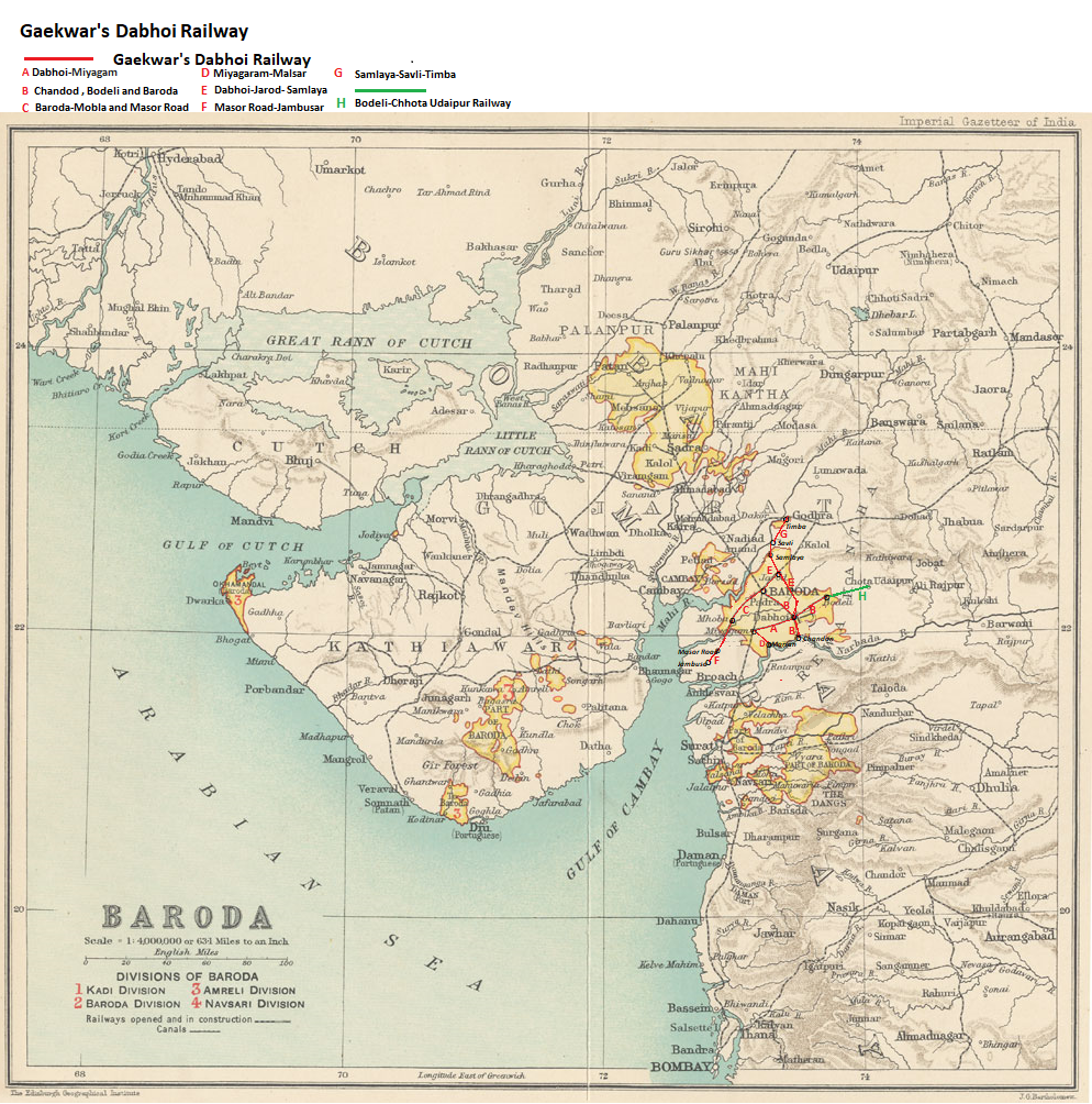
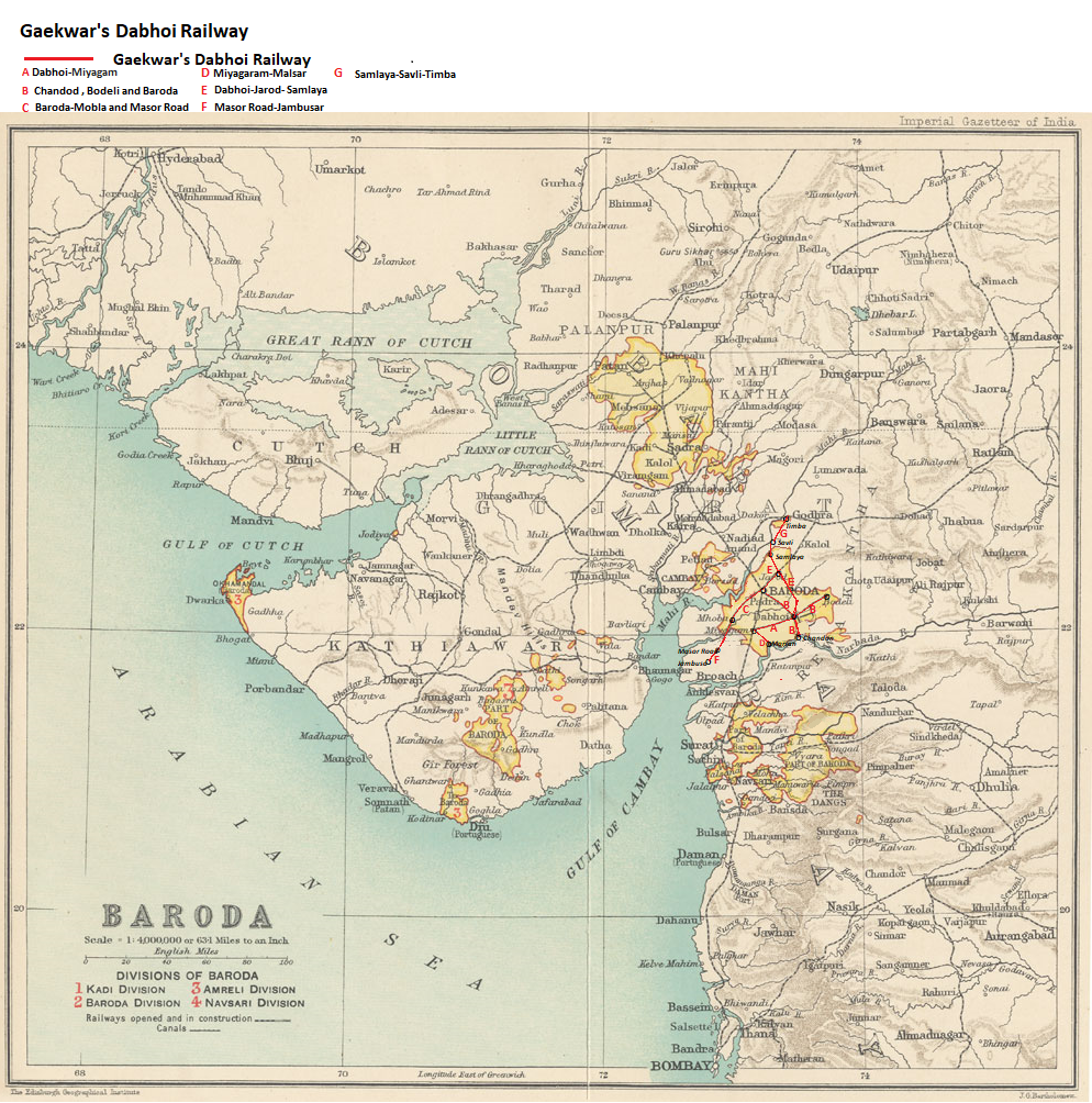
| 15:52, 9 February 2018 | Gaekwar's Dabhoi Railway Routes.png (file) |  |
1.56 MB | PEA-2292 | == Summary == '''Gaekwar's Dabhoi Railway''' Routes up to 1921 From "Imperial Gazetteer of India, v. 7, Atlas 1909 edition, "Baroda State Map", p. 64." Extracted and Zoomed using navigation window with routes and town names added [[Category:Railwa... |
| 14:05, 9 February 2018 | Gaekwar's Dabboi Railway Routes.png (file) |  |
1.66 MB | PEA-2292 | '''Gaekwar's Dabhoi Railway''' Routes up to 1921 From "Imperial Gazetteer of India, v. 7, Atlas 1909 edition, "Baroda State Map", p. 64." Extracted and Zoomed using navigation window with routes and town names added Category:Railway_maps |
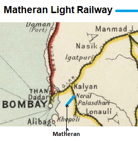
| 13:58, 7 February 2018 | Matheran Light Railway.png (file) |  |
101 KB | PEA-2292 | '''Matheran Light Railway''' From "Imperial Gazetteer of India, v. 26, Atlas 1909 edition, Railway Map--Sectional (1), p. 23." Extracted from [http://dsal.uchicago.edu/reference/gaz_atlas_1909/pager.html?object=29 Click here] and Zoomed using navigat... |
| 07:20, 6 February 2018 | Villupuram-Nellore Railway.png (file) |  |
374 KB | PEA-2292 | '''East Bengal Railway - Broad Gauge Division 1909''' '''Villupuram-Nellore Railway''' From "Imperial Gazetteer of India, v. 26, Atlas 1909 edition, Railway Map--Sectional (3), p. 25." Extracted from [http://dsal.uchicago.edu/reference/gaz_atlas_1909... |
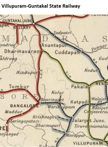
| 16:14, 5 February 2018 | Villupuram-Guntakal State Railway.png (file) |  |
291 KB | PEA-2292 | '''Villupuram-Guntakal State Railway''' From "Imperial Gazetteer of India, v. 26, Atlas 1909 edition, Railway Map--Sectional (3), p. 25." Extracted from [http://dsal.uchicago.edu/reference/gaz_atlas_1909/pager.html?object=31 Click here] and Zoomed us... |
| 15:33, 4 February 2018 | Tanjore District Board Railway.png (file) |  |
295 KB | PEA-2292 | '''Tanjore District Board Railway''' From "Imperial Gazetteer of India, v. 26, Atlas 1909 edition, Railway Map--Sectional (3), p. 54." Extracted from [http://dsal.uchicago.edu/reference/gaz_atlas_1909/pager.html?object=31 Click here] and Zoomed using... |
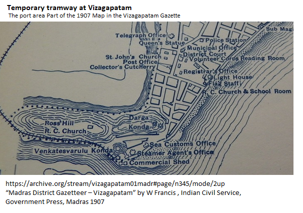
| 14:25, 4 February 2018 | Vizagapatam Temporary Tramway Port Area Map.png (file) |  |
373 KB | PEA-2292 | '''Vizagapatam Temporary Tramway''' “Madras District Gazetteer – Vizagapatam” by W Francis , Indian Civil Service, Government Press, Madras 1907 Map of Port Area of Vizagapatam, 1907 [https://archive.org/stream/vizagapatam01madr#page/n345/mode/... |
| 12:17, 4 February 2018 | South Indian Railway Network - 1908.png (file) |  |
597 KB | PEA-2292 | == Summary == '''South Indian Railway Network - 1908''' From Imperial Gazetteer of India, v. 26, 1909, Railway Map-Section 3, p. 25. Extracted from [http://dsal.uchicago.edu/reference/gaz_atlas_1909/pager.html?object=31 Click here] and Zoomed using... |
| 17:12, 22 January 2018 | Indus Valley State Railway ‘River Sutlej above and below Empress Bridge’.png (file) |  |
173 KB | PEA-2292 | '''Indus Valley State Railway Railway ‘Survey of River Sutlej above and below the Empress Bridge''' Map section from British Library IOR/V/24/2359 "Administration Report on the construction of the Indus Valley Railway" Page 34 Reproduced by permiss... |
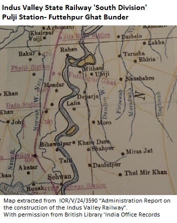
| 14:29, 21 January 2018 | Indus Valley State Railway 'South Division' Pulji Station-Futtehpur Ghat Bunder.png (file) |  |
263 KB | PEA-2292 | '''Indus Valley State Railway 'South Division' Pulji Station-Futtehpur Ghat Bunder''' Map section from British Library IOR/V/24/2359 "Administration Report on the construction of the Indus Valley Railway - Appendix" Reproduced by permission of ‘The... |
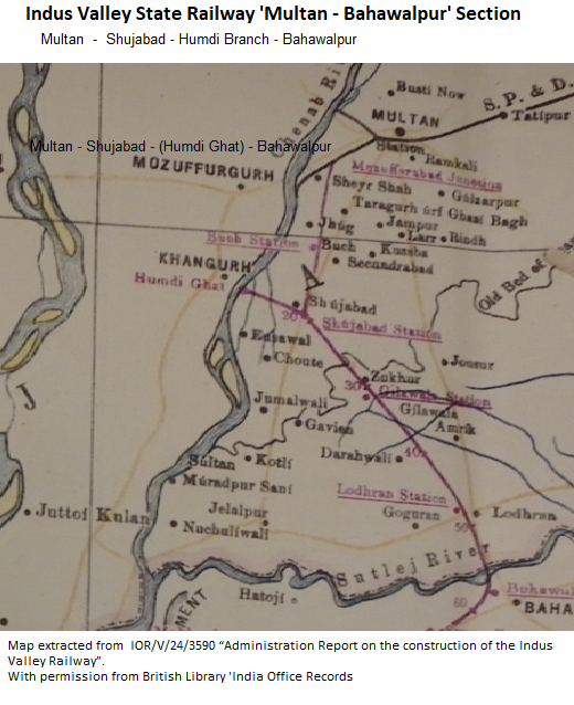
| 14:01, 21 January 2018 | Indus Valley State Railway 'Multan-Bahawalpur' Section.png (file) |  |
442 KB | PEA-2292 | '''Indus Valley State Railway 'Multan-Bahawalpur' Section''' Map section from British Library IOR/V/24/2359 "Administration Report on the construction of the Indus Valley Railway - Appendix" Reproduced by permission of ‘The British Library - India... |
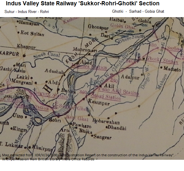
| 10:22, 21 January 2018 | Indus Valley State Railway 'Sukkor-Rohri-Ghotki' Section.png (file) |  |
649 KB | PEA-2292 | '''Indus Valley State Railway 'Sukkor-Rohri-Ghotki' Section''' Map section from British Library IOR/V/24/2359 "Administration Report on the construction of the Indus Valley Railway - Appendix" Reproduced by permission of ‘The British Library - Indi... |
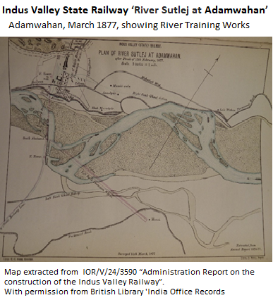
| 08:38, 21 January 2018 | Indus Valley State Railway ‘River Sutlej at Adamwahan’.png (file) |  |
212 KB | PEA-2292 | '''Indus Valley State Railway ‘River Sutlej at Adamwahan’ ''' Map section from British Library IOR/V/24/2359 "Administration Report on the construction of the Indus Valley Railway - Page 22" Reproduced by permission of ‘The British Library - In... |
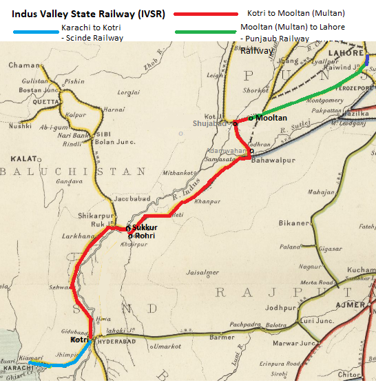
| 16:55, 20 January 2018 | Indus Valley State Railway.png (file) |  |
409 KB | PEA-2292 | '''Indus Valley State Railway''' Map taken from Imperial Gazetteer of India, v. 26, 1909, Railway Map-Section 1, p. 23 and suitably modified . To see original enhanced image [http://dsal.uchicago.edu/reference/gaz_atlas_1909/pager.html?object=29 Cl... |
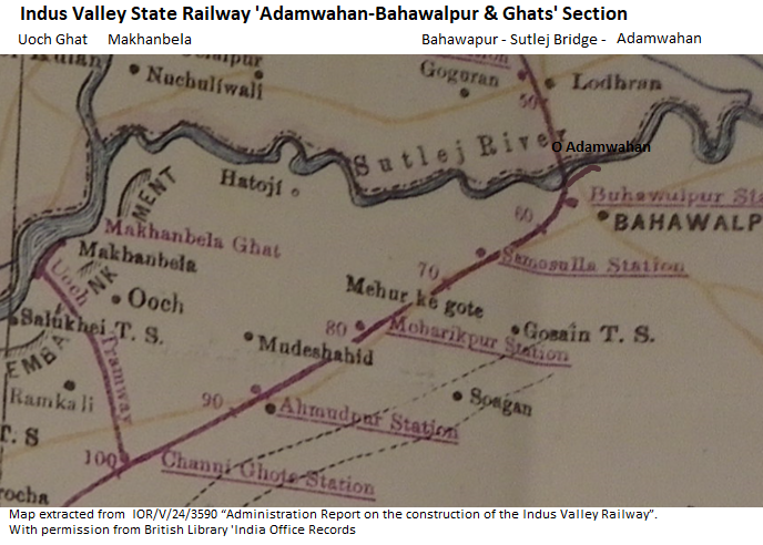
| 15:17, 20 January 2018 | Indus Valley State Railway 'Adamwahan-Bahawalpur & Ghats' Section.png (file) |  |
401 KB | PEA-2292 | '''Indus Valley State Railway 'Adamwahan-Bahawalpur & Ghats' Section''' Map section from British Library IOR/V/24/2359 "Administration Report on the construction of the Indus Valley Railway - Appendix" Reproduced by permission of ‘The British Libra... |
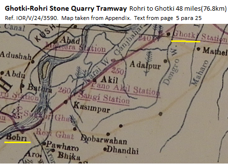
| 11:31, 19 January 2018 | Ghotki-Rohri Stone Quarry Tramway.png (file) |  |
248 KB | PEA-2292 | '''Ghotki-Rohri Stone Quarry Tramway''' Map section from British Library IOR/V/24/2359 "Administration Report on the construction of the Indus Valley Railway - Appendix" Reproduced by permission of ‘The British Library - India Office Records’.... |
| 15:26, 31 December 2017 | East Bengal Railway - Narrow Gauge System 1909.png (file) |  |
204 KB | PEA-2292 | '''East Bengal Railway - Narrow Broad Gauge System 1909''' From "Imperial Gazetteer of India, v. 26, Atlas 1909 edition, Railway Map--Sectional (2), p. 24." Extracted from [http://dsal.uchicago.edu/reference/gaz_atlas_1909/pager.html?object=30 Click... |
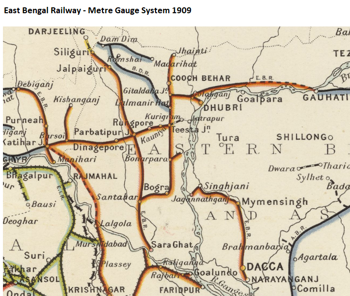
| 14:34, 31 December 2017 | East Bengal Railway - Metre Gauge System 1909.png (file) |  |
722 KB | PEA-2292 | '''East Bengal Railway - Metre Gauge System 1909''' From "Imperial Gazetteer of India, v. 26, Atlas 1909 edition, Railway Map--Sectional (2), p. 24." Extracted from [http://dsal.uchicago.edu/reference/gaz_atlas_1909/pager.html?object=30 Click here] a... |
| 14:26, 31 December 2017 | East Bengal Railway - Broad Gauge Division 1909.png (file) |  |
446 KB | PEA-2292 | '''East Bengal Railway - Broad Gauge Division 1909''' From "Imperial Gazetteer of India, v. 26, Atlas 1909 edition, Railway Map--Sectional (2), p. 24." Extracted from [http://dsal.uchicago.edu/reference/gaz_atlas_1909/pager.html?object=30 Click here]... |
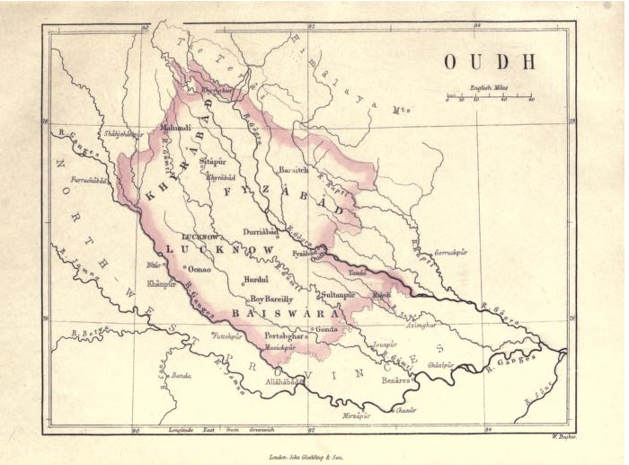
| 10:14, 18 December 2017 | Oude Province 1871.png (file) |  |
554 KB | PEA-2292 | '''Oude Province 1871 Map''' Map from 'A Text Book of Indian History' by Rev G U Pope Section §11 pdf page 24. Published by J.Gladding & Co, London, 1871 [[https://archive.org/stream/textbookofindian00popeuoft#page/n24/mode/1up Archive.org 'A Text Bo... |
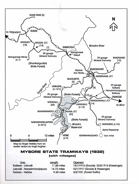
| 05:57, 4 October 2017 | Mysore State Tramways.jpg (file) |  |
90 KB | PEA-2292 | ''' Mysore State Tramways''' Map from "Industrial Railway Record 212 March 2013 The Mysore Iron & Steel Works" by Allan C Baker, page 495 ‘Map of the Mysore State Tramways’, drawn by Rodger Hateley from an earlier version by Hugh Hughes. Reproduce... |
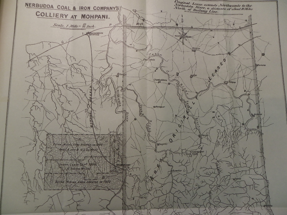
| 06:27, 27 August 2017 | Mohpani-Nerbudda Colliery Railway.png (file) |  |
1.26 MB | PEA-2292 | '''Mohpani/Nerbudda Colliery''' ‘Nerbudda Coal & Iron Company’ British Library Indian Office Records L/F/8/17/1298 “GIPR Contacts for working the Nerbudda Colliary”. Photograph of map by permission of British Library. [[Category:Ra... |