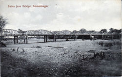
Ahmadnagar
| Ahmadnagar | |
|---|---|

| |
| Presidency: Bombay | |
| Coordinates: | 19.095003°N 74.756679°E |
| Altitude: | 649 m (2,129 ft) |
| Present Day Details | |
| Place Name: | Ahmednagar |
| State/Province: | Maharashtra |
| Country: | India |
| Transport links | |
| Dhond-Manmad State Railway | |
| FibiWiki Maps | |
|---|---|
| See our interactive map of this location showing places of interest during the British period | |
| Ahmadnagar |
THIS PAGE IS WAITING FOR MORE DETAILED INFORMATION
Ahmadnagar was the headquarters of Broach District in the Central division of Bombay Presidency during the British period.
Ahmednagar was the location of the Royal Tank Corps School from the early 1920s, and the Machine Gun School
Spelling Variants
Modern name: Ahmednagar
Variants: Ahmednuggur/Ahmadnagat
History
Military history
External links
- Ahmednagar Love to Know 1911
- Ahmadnagar Imperial Gazetteer
- "Where freedom held fort" by Himmat Singh Gill Sunday, September 3, 2006 tribuneindia.com. The Ahmednagar Fort held political prisoners in the 1940s including Pandit Jawaharlal Nehru
- Scroll down Incredible Ahmednagar, for details of the Tank Museum, established by the Armored Corps Centre and School, Ahmednagar in February 1994. Photographs on picasaweb rahul m’s Gallery, morakhandi v’s Gallery. Article "Tanks down the years" by Rajendra Rajan, tribuneindia.com Sunday, May 24, 2009
Historical books online
- "Ahmadnagar City" Imperial Gazetteer of India, Volume 5, page 123.
- Ahmednuggur, in the Deccan, is listed in a List of all the military stations in the Bombay Presidency, with details, page 235 Transactions of the Medical and Physical Society of Bombay, Volume VII, New Series 1861 Google Books
- Tales of Ahmednagar by Captain Cecil Cowley, 2nd Garrison Battalion, Northumberland Fusiliers 1919 Archive.org. History of Ahmednagar, mostly for the pre British period.