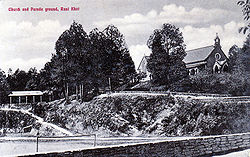
Ranikhet
| Ranikhet | |
|---|---|

| |
| Presidency: Bengal | |
| Coordinates: | 29.65°N 79.42°E |
| Altitude: | 1,869 m (6,132 ft) |
| Present Day Details | |
| Place Name: | Ranikhet |
| State/Province: | Uttarakhand |
| Country: | India |
| Transport links | |
Ranikhet was an important military hill station in the District and tahsil of Almora, United Provinces

"The Cantonment comprises Ranikhet proper, Kumpoor, Chaubattia and the standing camp also known as Dulikhet and is about 6 km long with an average breadth of 8 miles and has an area of 4,262.61 acres. ...In 1868, the site was selected for stationing British Troops and the following year the Cantonment was established"[1]
Chaubattia is situated about 7 km from Ranikhet.
Ranikhet Cantonment Authority was established in 1869. Minutes of the Cantonment Committee are available in the Cantonment Board Office from 1869. In 1870 log huts were constructed in Ranikhet for accommodation of troops and the 37th Hampshire Regiment was sent up and worked making roads, cleaning and leveling the sites for construction of Barracks.[2]
Spelling variants
Modern spelling: Ranikhet
Variants: Rannikhet/Rani Khet/Ranee Khet/Raniket/Rhaniket
Modern spelling: Chaubatia
Variants: Chaubattia/Chaubatia/Chaubathia
Churches
- St Bridget's Church, Chaubattia (Built 1884). [3]
External links
- Ranikhet Wikipedia (retrieved 19 May 2016)
- Chaubatia Wikipedia (retrieved 19 May 2016)
- Ranikhet: the Raj relived by Saionton Basu 22 July 2009 livemint.com
- Photograph: Alma Barracks Ranikhet c 1945-48 from the Eddie Holmes Photos Collection. Lancashire Fusiliers XX lancs-fusiliers.co.uk
Historical books online
- "Ranikhet" Imperial Gazetteer of India, Volume 21, page 233.
References
- ↑ Ranikhet indiatoursservice.com
- ↑ Cantonment Board, Ranikhet
- ↑ bareillydiocese.org