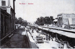
Roorkee
| Roorkee | |
|---|---|

| |
| Presidency: Bengal | |
| Coordinates: | 29.874858°N 77.889928°E |
| Altitude: | 268 m (879 ft) |
| Present Day Details | |
| Place Name: | Roorkee |
| State/Province: | Uttarakhand |
| Country: | India |
| Transport links | |
Roorkee was the headquarters of the tahsil of the same name and a cantonnement in Saharanpur District, United Provinces. Home of Thomason College for Military Engineers studying to join the Public Works Department and Headquarters for the Bengal Sappers and Royal Engineers in Bengal.
The establishment of Thomason College at Roorkee in 1847 was linked to the construction of the Upper Ganga Canal, the most important irrigation project being undertaken at the time. In his propoasal submitted to Government, the Lt .Governor James Thomason, had justified the location on the basis that the establishment forming at Roorkee, near the Solani Aqueduct on the Ganga Canal, afforded particular facilities for instructing Civil Engineers [1] and one of the first places in India to use Railways for Construction.
Spelling variants
Modern name: Roorkee
Variants: Rourkee, Rourke, Rurki
FIBIS Resources
- Transcriptions of gravestones in Roorkee Cemetery FIBIS database
External links
- William Holmes, later Lt. Col. John David William Holmes MC, born 1877, in his Autobiography, Chapter 2 (from The Progonion) describes a year studying at the Civil and Military Engineering College at Roorkee c 1897 ( scroll about a third of the way down the page)
Historical books online
- Roorkee Town Imperial Gazetteer
- Account of Roorkee College established for the instruction of civil engineers, with a scheme for its enlargement. Printed by order of the ... lieutenant governor of the North Western Provinces. 1851 Archive.org
- "Roorkee" page 377 Report of the Commissioners Appointed to Inquire into the Sanitary State of the Army in India : with Abstract of Evidence, and of Reports Received from Indian Military Stations 1864 Archive.org
- India and Indian Engineering by Major J G Medley 1873 ex Principal of Thomason College, Roorkee. Good overview of the training, life and work of engineers in India. Archive.org
- Mahatma Gandhi Central Library, Indian Institute of Technology, Roorkee with a link to the Bhagirathi Archival Collection, which has books and documents relating to Roorkee and Engineering which may be downloaded as pdfs. Try the Search term Roorkee or Rourkee.
References
- ↑ Water Resources Development: The Role of Roorkee University of Roorkee