Difference between revisions of "Darjeeling-Himalayan Railway"
HughWilding (talk | contribs) (Map & gallery added) |
HughWilding (talk | contribs) (Alternate map added) |
||
| Line 52: | Line 52: | ||
<gallery> | <gallery> | ||
Image:DHR double loop 92.jpg|View of the double loop | Image:DHR double loop 92.jpg|View of the double loop | ||
| + | Image:DHR 1942c.jpg|Alternative map | ||
Image:{filename}|{caption} | Image:{filename}|{caption} | ||
{...} | {...} | ||
Revision as of 14:32, 17 February 2009
| Darjeeling-Himalayan Railway | ||
|---|---|---|
| File:DHR 1942 map.jpg 1942 map | ||
| Line of route | ||
| Siliguri to Darjeeling Siliguri to Kalimpong Road Siliguri to Kishanganj | ||
| Gauge / mileage | ||
| 2' 0" NG | 51 miles (1905) 147 miles (1943) | |
| Timeline | ||
| 1879 | Company formed | |
| 1880 | First section opened to traffic | |
| 1881 | Line opened through to Darjeeling | |
| 1913 | Extension to Kishanganj planned | |
| Key locations | ||
| Presidency | Bengal | |
| Stations | Siliguri, Sukna, Rangtong, Chunbatti, Tindharia, Gayabari, Mahanadi, Kurseong, Tung, Dilaran, Sonada, Rangbul, Jor Bungalow, Ghum, Darjeeling Kalimpong Road, Kishanganj | |
| System agency | ||
| 1880 | Own agency | |
| 1958 | North East Frontier Railway (IR zone) | |
| How to interpret this infobox | ||
The Darjeeling-Himalayan Railway (DHR), a 2' 0" narrow gauge line dating from 1879 and still powered by steam, is today a major tourist destination and UNESCO World Heritage site.
History
Built between 1879 and 1881, the original line ran (and still does) for 51 miles from Siliguri (about 100m in altitude) to Darjeeling (about 2200m).
In 1913, the system was extended from Siliguri south-westwards to Kishanganj. There was also a short branch from Siliguri to Kalimpong Road. Technically, these extensions were a separate company, worked by the agency of the first.
As an assisted railway, the DHR fell into the control of Indian Railways (IR) after independence, and in 1958 became part of North East Frontier Railway, an IR zone.
External links
"A Himilayan loop line" Mike's Railway History.
"Darjeeling Himalayan Railway" Wikipedia.
Gallery
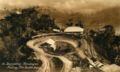
View of the double loop
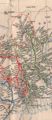
Alternative map

