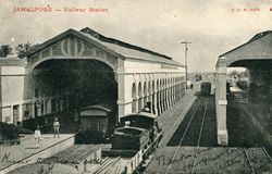
Jamalpur
| Jamalpur | |
|---|---|

| |
| Presidency: Bengal | |
| Coordinates: | 25.3°N 86.5°E |
| Altitude: | 151 m (495 ft) |
| Present Day Details | |
| Place Name: | Jamalpur |
| State/Province: | Bihar, Bengal wikipedia |
| Country: | India |
| Transport links | |
| East Indian Railway | |
Jabalpur was the headquarters of the subdivision of Monghyr District during the British period.
Situated 299 miles from Calcutta, "Jamalpur is the head-quarters of the locomotive department of the East Indian Railway and contains the largest manufacturing workshops in India". (Imperial Gazetteer of India, 1908)
The Locomotive workshops were established in 1862. On 15 January 1934, the workshops along with the entire railway colony were destroyed by an earthquake. It took 3 years to rebuild the facility.
Contents
Spelling variants
Modern name: Jabalpur
Variants: Jamalpore
Also see
External links
- Jamulpur, Munger Wikipedia including
- JamalpurImperial Gazetteer on Digital South Asia website.
- "On Jamalpur - Anglo-Indian Railway Officers", by Blair Williams The International Journal of Anglo-Indian Studies Volume 6, Number 2, 2001
- Railway Colonies in India by John Alton Price. Includes his time in Jamalpur with the Army in 1942. From his family website, now archived. Some of the photographs from the article are available on flickr.com Railway Siding in Jamalpur, Railway line past No 2 sub-depot, Forest Camp near Jamalpur, Bihar, Our Tent in the forest, First locomotive on East Indian Railway, Amunition valley - Jamalpur, Sunday walk - hills near Jamalpur
- Jamalpur Workshops irfca.org
- Jamalpur Railway Workshops 1897 Part 1 , Jamalpur Railway Workshops 1897 Part 2 oldindianphotos.in
- Photograph of Workshops [Jamalpur] - East End after the Earthquake of 12th June 1897. British Library Online Gallery
- Video on history and present of Jamalpur workshop Eastern Railway You Tube
- Jamalpur Railway Workshop thejamalpur.wordpress.com
- "Railways to modernize Jamalpur workshop" by Kumod Verma, February 10, 2012 The Times of India Patna. Includes history of the workshop
- Photograph of the gravestone of “Thomas Ouilon Roberts, formerly of the Volcan Foundry, Waddington and after wards Foreman of the Locomotive Erecting Shop, Jamalpur, who lost his life from the effects of an encounter with a tiger, near this place. Died 13th Day June, 1864 Age 27 years” flickr.com
Historical books online
- Jamalpur Town Imperial Gazetteer of India
- Among the Railway Folk by Rudyard Kipling 1888. Web edition published by eBooks@Adelaide.
- Article Among the Railway Folk from Kipling.org.uk