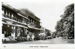
Jubbulpore
Jump to navigation
Jump to search
| Jubbulpore | |
|---|---|

| |
| Presidency: Bengal | |
| Coordinates: | 23.16527°N, 79.945545°E |
| Altitude: | 1,393 m (4,570 ft) |
| Present Day Details | |
| Place Name: | Jabalpur |
| State/Province: | Madhya Pradesh |
| Country: | India |
| Transport links | |
| East Indian Railway Great Indian Peninsula Railway Bengal-Nagpur Railway | |
| FibiWiki Maps | |
|---|---|
| See our interactive map of this location showing places of interest during the British period | |
| [xxxxx Jubbulpore] |
Contents
THIS PAGE IS WAITING FOR MORE DETAILED INFORMATION
Jubbulpore was the headquarters of Jubbulpore District in the Jubbulpore Division of Central Provinces during the British period.
The town was the meeting point in 1871 for the Great Indian Peninsula Railway (616 miles from Bombay) and the East Indian Railway (220 miles from Allahabad), and the completion of the first Bombay-Calcutta trunk railway line.
Spelling Variants
Modern name: Jabalpur
Variants: Jubbulpore
FIBIS Resources
External links
- Jubbulpore City Imperial Gazetteer of India
- Image: Invitation to a banquet at Jubbulpore to mark the opening of the North East Extension of the G I P Railway March 1870. Includes the wording: "Tents will be provided but visitors should bring their own bedding…" Image 104 History of great indian railways by Aish Warya slideshare.net. Enter 104 in the relevant box, and select enter on your computer. Click the symbol beside the number box to enlarge. Retrieved 30 August 2014