Muttra: Difference between revisions
Jump to navigation
Jump to search
Symorsebrown (talk | contribs) Create page. Add info box and external link |
add image |
||
| Line 1: | Line 1: | ||
{{Locations_Infobox | {{Locations_Infobox | ||
|presidency= | |presidency= | ||
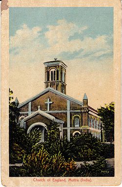
|image= | |image=Church of England Muttra.jpg | ||
|coordinates= [http://maps.google.co.uk/maps?ll=27.492739,77.666121&z=14&t=h&hl=en 27.492739°N 77.666121°E] | |coordinates= [http://maps.google.co.uk/maps?ll=27.492739,77.666121&z=14&t=h&hl=en 27.492739°N 77.666121°E] | ||
|altitude=174 metres (570 feet) | |altitude=174 metres (570 feet) | ||
Revision as of 11:18, 11 October 2011
| Muttra | |
|---|---|

| |
| Presidency: | |
| Coordinates: | 27.492739°N 77.666121°E |
| Altitude: | 174 metres (570 feet) |
| Present Day Details | |
| Place Name: | Mathura |
| State/Province: | Uttar Pradesh |
| Country: | India |
| Transport links | |
Muttra, or Mathura, was a city and district of British India in the Agra division of the United Provinces. Today it is a city of some 2.5 million people on the right bank of the Jumna in the Indian state of Uttar Pradesh.
External links
Muttra www.1911encyclopedia.org