Nilgiri Hills: Difference between revisions
Jump to navigation
Jump to search
Symorsebrown (talk | contribs) Add infobox |
Symorsebrown (talk | contribs) Add image |
||
| Line 1: | Line 1: | ||
{{Locations_Infobox | {{Locations_Infobox | ||
|presidency= [[Madras]] | |presidency= [[Madras]] | ||
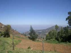
|image= | |image=Nilgiri view.jpg | ||
|coordinates= [http://maps.google.com/maps?ll=12.414,76.758333&spn=0.1,0.1&q=11.375,76.704 11.375°N 76.758333°E] | |coordinates= [http://maps.google.com/maps?ll=12.414,76.758333&spn=0.1,0.1&q=11.375,76.704 11.375°N 76.758333°E] | ||
|altitude= 24 peaks above 2,000m (6,600 ft) | |altitude= 24 peaks above 2,000m (6,600 ft) | ||
Revision as of 15:25, 14 February 2012
| Nilgiri Hills | |
|---|---|

| |
| Presidency: Madras | |
| Coordinates: | 11.375°N 76.758333°E |
| Altitude: | 24 peaks above 2,000m (6,600 ft) |
| Present Day Details | |
| Place Name: | Nilgiri Hills |
| State/Province: | Tamil Nadu |
| Country: | India |
| Transport links | |
| Nilgiri Mountain Railway | |
Ootacamund is the main town.
Refer also
External links
Historical books online
- Observations on the Neilgherries by Robert Baikie MD 1834 Google Books
- The Neilgherries: including an account of their topography, climate, soil and productions; and of the effects of the climate on the European constitution by Robert Baikie MD 1857 2nd edition, updated. Archive.org
- A Manual of the Nílagiri District in the Madras Presidency by HB Grigg 1880 Archive.org
- Madras District Gazetteers: The Nilgiris by W Francis 1908 Archive.org
- The Nilgiri Guide and Directory by JSC Eagan 1916 Archive.org