Belgaum: Difference between revisions
Jump to navigation
Jump to search
Symorsebrown (talk | contribs) Amend info box. Add external link |
Symorsebrown (talk | contribs) Amend external link |
||
| Line 19: | Line 19: | ||
[[Siege of Belgaum]] 1818 | [[Siege of Belgaum]] 1818 | ||
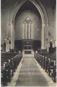
[[Image:St Mary's Church, Belgaum.jpg|right|thumb|200px|''Interior St Mary's Church, Belgaum'']] | |||
==Churches== | ==Churches== | ||
[http://www.bdtapvtltd.org/belgaum.htm St Mary's Church, Belgaum] Bombay Diocesan Trust | [http://www.bdtapvtltd.org/belgaum.htm St Mary's Church, Belgaum] Bombay Diocesan Trust | ||
==External links== | ==External links== | ||
====Historical books on-line==== | ====Historical books on-line==== | ||
[http://www.archive.org/stream/ | [http://www.archive.org/stream/cu31924070623727#page/n5/mode/2up Belgaum] Gazetteer of the Bombay Presidency Vol XXI 1884 | ||
[[Category:Locations]] | [[Category:Locations]] | ||
Revision as of 11:33, 22 March 2012
| Belgaum | |
|---|---|
| [[Image:|250px| ]] | |
| Presidency: Bombay | |
| Coordinates: | 15.850362°N 74.504672°E |
| Altitude: | 762 m (2,500 ft) |
| Present Day Details | |
| Place Name: | Belgaum Belgaum |
| State/Province: | Karnataka |
| Country: | India |
| Transport links | |
| Southern Mahratta Railway | |
Belgaum, a town and district of British India, in the southern division of Bombay. The town is situated 245 miles south of Poona; it has a station on the Southern Mahratta railway.
Spelling variants
Modern name: Belgaum
Variants: Belgaon
Military history
Siege of Belgaum 1818

Churches
St Mary's Church, Belgaum Bombay Diocesan Trust
External links
Historical books on-line
Belgaum Gazetteer of the Bombay Presidency Vol XXI 1884