Darjeeling
| Darjeeling | |
|---|---|

| |
| Presidency: Bengal | |
| Coordinates: | 27.037559, 88.263044 |
| Altitude: | 2,134 m (7,001 ft) |
| Present Day Details | |
| Place Name: | Darjeeling |
| State/Province: | West Bengal |
| Country: | India |
| Transport links | |
| Darjeeling-Himalayan Railway | |
| FibiWiki Maps | |
|---|---|
| See our interactive map of this location showing places of interest during the British period | |
| Darjeeling |
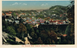
Darjeeling was a hill station in Bengal.
There were military cantonments at Jalapahar (alternative spelling Jellapahar) (established 1848), Darjeeling and at Lebong, situated below Darjeeling about eight miles away. Lebong cantonment was established in 1882 as part of the Jalapahar cantonment, and became a separate cantonment in 1895.[1]There were artillery barracks at Katapahar, above Darjeeling and it appears that this was what was called the Darjeeling cantonment. The term "Darjeeling cantonment" seems at times to have also included Jalapahar, which was a convalescent depot. Senchal was a station five miles from Darjeeling, at an elevation of about 8, 600 feet.
Spelling variants
Darjeeling, Darjeling, Darjiiling, Darjiling
Cemeteries
- Darjeeling Old Cemetery darjeeling-tourism.com (This cemetery is also known as Hill Cart Road Cemetery or Hooker Road cemetery)
- Named images of graves at Hill Cart Road cemetery Fibis database
- Darjeeling’s English Cemetery by Rebecca Bragg with informative comments at the end, November 06, 2009 DarjeelingTimes.com, (now archived), a subsequent article dated 7 February 2010 (now archived) and also the updated information from her website including a Questions and Answer session with a BACSA representative in July 2010 and Cemetery photos
- Darjeeling New Cemetery. (Singtom Cemetery] Established 1858. A report [2]in 2007 mentions that the Singtom cemetery is in a neglected state and gravestones have disappeared.
- The Jewish cemetery. The approximate location is mentioned in the comments by Peter J. Karthak on November 8, 2009 in Rebecca Bragg's article above.
- Jalahapar Old Cemetery
- Jalahapar New Cemetery
A BACSA (British Association for Cemeteries in South Asia) cemetery publication is
- Darjeeling and the Dooars: Christian Cemeteries and Memorials 1842–1995 by Eileen Hewson, 2006. A record of the cemeteries and isolated graves from this corner of India with MIs and biographical notes on the planters and other notable tombs. 93pp, 23 illustrations, and map. See BACSA Books. (BACSA are in the process of putting the indexes to its cemetery books online and these indexes are free to browse. If an indexed name is of interest then application can be made to BACSA for details of the relevant burial inscription - charges apply for this service).
Churches and Missions

- St Columba's Church (Estab 1894) trekearth.com
- Immaculate Conception Church (Catholic) - (Estab 1848)
- Sacred Heart Church - (Catholic) - (Estab 1898)
Schools and Colleges


(See also Schools)
- Bethany College
- Bishop Cotton School
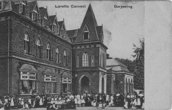
- Loretto Convent
- Mount Hermon School
- St Joseph's , North Point
- North Point Annuals from 1895 including
- The North Point Annual Volume II, No 5, 1917 html version, pdf. Includes details of students' war service.
- A Century Observed 1888-1898 History of the School
- North Point Annuals from 1895 including
- St Paul's (Jalapahar)
Records
- The British Library has the following book in its catalogue:
- Taylor’s Maps of the following Tea Districts, Darjeeling, Terai, Jalpaiguri and Dooars, Darrang, Golaghat, Jorhat Nowgong, Sibsagar, Lakhimpur, Dibrugarh, Cachar, Sylhet, with complete Index to all Tea Gardens, published 1910
Related Articles
- Tea Plantation
- Darjeeling-Himalayan Railway
- Darjeeling Images Fibiwiki page containing various images of Darjeeling - click on thumbnails to expand.
External Links
- Darjeeling Wikipedia
- Jalapahar Wikipedia
- Darjeeling from the website Koi-Hai
- Darjeeling Tea History
- Photograph of a tea plantation, Darjeeling.
- Photos of Darjeeling from Old Indian Photos
- Old photographs of Darjeeling from the Das Studio Photo Archives from Ratna D Pradhan’s Himalayan Light: Images of the Himalayas
- Scroll down for some photographs of Darjeeling from an 1887 album from Albumen photographs of the 19th Century.
- Old Mount Hermon Students' Association (UK)
- St. Paul’s School, Darjeeling 1937-38 by Khwaja Sayeed Shahabuddin (born 1923)
- Photographs:Darjeeling English Cath Forrest’s collection on flickr.com. Includes the wording "...the New School, set up during the Second World War to educate the children of British families in India safely, away from the threat of Japanese bombs, was closed at the end of the war. My mother and her classmates, some as young as five, were sent up here all the way from Calcutta on the Darjeeling Mail and the Toy Train.".
- "Darjeeling is all the Raj" by Michael Gebicki August 01, 2009 news.com.au. Article about a hotel in Darjeeling “where the clock stopped ticking circa 1930”, and where the library has a substantial collection relating to India's railways.
- The cantonment at Lebong 1910 Postcard from Images of Asia
- Photograph: Missionary being taken up hill on a litter [dandy], Darjeeling, ca.1890 Photographs from Scottish Missions, the National Library of Scotland. USC Digital Library
Online books
- "Darjeeling Town" Imperial Gazetteer of India, Volume 11, page 178
- "Jalapahar" Imperial Gazetteer of India, Volume 14, page 17.
- "Lebong" Imperial Gazetteer of India, Volume 16, page 158.
- "Map of Darjeeling" between pages 314 and 315, A Handbook for Travellers in India, Burma, and Ceylon published by John Murray, London Eighth Edition 1911 Archive.org.
- "“Bye Laws” and Office Rules at Darjeeling 1st August 1841" page 263 The Bengal and Agra Annual Guide and Gazetteer for 1842 Volume II Google Books
- "Darjeeling" page 396 Report of the Commissioners Appointed to Inquire into the Sanitary State of the Army in India : with Abstract of Evidence, and of Reports Received from Indian Military Stations 1864 Archive.org
- The station of Senchal, five miles from Darjeeling c 1865 is mentioned in " India: Bengal. Report" by C. Macnamara, Medical Officer-in-Charge of the "Chandnie" Hospital, Calcutta, and Surgeon to the Ophthalmic Hospital. Page 89 Reports on the progress of practical and scientific medicine, ed. by H. Dobell, Volume 2, 1871 Google Books
- Bengal District Gazetteers: Darjeeling by L.S.S.O’Malley (reprint 1985/1999, original 1907) is available to download as a searchable pdf file at DSpace at West Bengal State Central Library. Also available as Google Books Preview
- "The cantonments at Darjeeling", page 189
- "Jalapahar", page 191
- "Lebong", page 201
- "Darjeeling" page 196 Calcutta Review Volume 28, January-June 1857 Google Books
- A Sketch of the Physical and Topographical Characters and Other Relations of the Hill Sanitaria of Darjeeling, Nynee Tal, Landour and Murree, in the Bengal Presidency, page 305 Army Medical Department: Report for the Year 1862 Google Books
- The Darjeeling Himalayan Railway: Illustrated Guide for Tourists 1896 Archive.org
- Darjeeling is mentioned in the first chapter of Among the Himalayas by Major L A Waddell, Indian Army Medical Corps 1899 edition, 2nd edition 1900 Archive.org
- Newman's Guide to Darjeeling and Its Surroundings, Historical & Descriptive 1900 Archive.org
- Newman’s Guide to Darjeeling 1930. Pdf download Pahar- Mountains of Central Asia Digital Dataset
- Darjeeling & its Mountain Railway: A Guide and Souvenir published by the Darjeeling-Himalayan Railway Co. Ld. 1921 vsdh.org
- Chapter 6 "Suburbs of Darjeeling" includes details about the cantonments at Lebong, Jalapahar and Katapahar (although confusingly the latter is also called Jalapahar)
- This book is also available to download as a pdf file from Pahar-Mountains of Central Asia Digital Dataset
- History Of The Darjeeling District by E C Dozey 1917 is available to read online on the Digital Library of India website. Refer Online books-Digital Library of India for more details about this site. A chapter on schools commences computer page 99, and a chapter on cemeteries, with details of some burials, commences computer page 140. Note some pages appear to be missing.
- A revised 2nd edition, published c 1922 is titled A Concise History of the Darjeeling District since 1835 by E C Dozey Archive.org. This edition is also available to read online on the Digital Library of India website. The chapter on cemeteries commences page 146.
- “Darjeeling” from Bengal and Assam, Behar and Orissa : their history, people, commerce and industrial resources by Somerset Playne 1917 Archive.org
- "Beriberi in Lebong" [in 1914] by Major J C Kennedy, Royal Army Medical Corps, Journal of the Royal Army Medical Corps, page 268 September 1915
- The Magic Mountains: Hill Stations and the British Raj by Dane Kennedy, 1996 University of California Press
References
- ↑ Dr. Wangyal's Column : Discursive Hills November 2008 mygorkhaland.wordpress.com
- ↑ India List post by James Sinclair