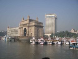
Bombay (City)
| Bombay (City) | |
|---|---|

| |
| Presidency: Bombay | |
| Coordinates: | 19.017656°N, 72.85618°E |
| Altitude: | 8 m (26 ft) |
| Present Day Details | |
| Place Name: | Mumbai |
| State/Province: | Maharashtra |
| Country: | India |
| Transport links | |
| Bombay, Baroda and Central India Railway Great Indian Peninsula Railway Bombay Port Trust Railway | |
Bombay (now Mumbai) was the capital of the Bombay Presidency and is now the capital of the state of Maharashtra.
History
The city was Portuguese controlled from 1534 and under British rule from 1661. Until the 18th century, Bombay consisted of seven islands. The islands were merged to form the present day location of the city.
Churches
Anglican
- St. Thomas Cathedral - the oldest Anglican church in the city, built in 1718, consecrated 1816, became the cathedral of the See of Bombay in 1833. On the south side of Church Gate Street. Origianlly the garrison church.
Presbyterian
- St John the Evangelist, Colaba - aka the Afghan Church, consecrated 1858. Built to commemorate the dead of the 1st Afghan War.
Roman Catholic
Addresses of all current Catholic Churches in Mumbai (Archdiocese of Mumbai). See also Bombay in the Catholic Encyclopedia 1913.
- Cathedral of the Holy Name
- Gloria Church - aka Nossa Senhora de Gloria, founded 1632
- Mount Mary Church, Bandra - aka the Basilica of Our Lady of the Mount
- Our Lady of Egypt - founded 1606
- Our Lady of Good Country - aka Nossa Senhora de Bom Concelho, founded 1596
- Our Lady of Salvation - aka Nossa Senhora de Salvação or the Portuguese Church, founded 1596, current structure is 1974
- St. Andrew's Church - built 1575
- St Michaels - founded by the Portuguese in 1534 (current building dates only to 1973)
- St Peter's, Bandra - Jesuit church. Original building 1852, current building 1938, consecrated 1964
- Scottish Free Church
External links
- Bombay City Love to Know 1911.
- Mumbai Wikipedia.
- History of Mumbai Wikipedia.
- Bombay Map 1909 from the Asia Historical Maps Collection, University of Texas, Austin