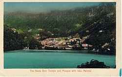
Naini Tal
| Naini Tal | |
|---|---|

| |
| Presidency: Bengal | |
| Coordinates: | 29.38°N, 79.45°E |
| Altitude: | 2,084 m (6,837 ft) |
| Present Day Details | |
| Place Name: | Nainital |
| State/Province: | Uttarakhand |
| Country: | India |
| Transport links | |
Bhim Tal , modern name Bhimtal (Wikipedia) is situated 22 kilometres from Naini Tal . It was the location of a Boer prisoner of war camp , established in 1902 at the north end of the lake, according to this link[1]
Approximately 65 kilometres (40 miles) from Nainital is the Jim Corbett National Park The author of this India List post has happy memories of her young days in the forests of Kumaon near the Jim Corbett National Park.
Spelling Variants
Modern name: Nainital
Variants: Nynee Tal/Naini Tal
External links
- History of Nainital and Rare Old British Era Picture Gallery Of Nainital Nainital Tourism
Historical books online
- "Naini Tal town" Imperial Gazetteer of India, Volume 18, page 333.