File:1909 Railways, Key to Maps.png

Size of this preview: 241 × 600 pixels. Other resolution: 242 × 602 pixels.
Original file (242 × 602 pixels, file size: 264 KB, MIME type: image/png)
Summary
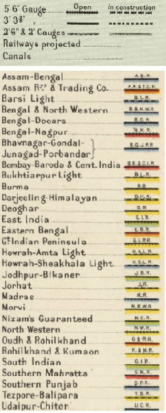
1909 Railways, Key to Maps
Extracted from “Imperial Gazetteer of India”, v. 26, 1909, Railway Map-Section 3, p. 25.
See Click here and Zoom using navigation window
Licensing
|
|
This work is licensed under the Creative Commons Attribution 3.0 License. Specific Attribution: None specified Anyone may use this image for any purpose provided it is attributed as specified. |

File history
Click on a date/time to view the file as it appeared at that time.
| Date/Time | Thumbnail | Dimensions | User | Comment | |
|---|---|---|---|---|---|
| current | 09:36, 1 October 2016 | 242 × 602 (264 KB) | PEA-2292 (talk | contribs) | '''1909 Railways, Key to Maps''' Extracted from “Imperial Gazetteer of India”, v. 26, 1909, Railway Map-Section 3, p. 25. See [http://dsal.uchicago.edu/reference/gaz_atlas_1909/pager.html?object=31 Click here] and Zoom using navigation window... |
You cannot overwrite this file.
File usage
There are no pages that use this file.