How to interpret this infobox
| How to interpret this infobox | ||
|---|---|---|
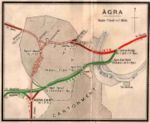
 Agra rail connections, 1938 | ||
| Line of route | ||
| Agra East Bank to Belanganj Drummond Road to Alumganj | ||
| Gauge / mileage | ||
| MG | 12 miles (1938) | |
| Timeline | ||
| 1890 | Line opened to traffic | |
| Key locations | ||
| Presidency | Bengal | |
| Stations | Agra East Bank, Agra Fort, Idgrah | |
| System agency | ||
| 1900 | worked by BB&CIR | |
| How to interpret this infobox | ||
A Line infobox is used to summarize information about a particular railway. A Line infobox is always framed in grey and the railway's name will usually appear on the title bar along the top of the gray
A word or phrase of the data highlighted in blue indicates an internal link to another article which will provide further information. Use your browser's back button to return to this explanation. A word or phrase in red will indicate that although the link has been established, there is as yet no content to go to.
Space is provided for an appropriate image or route diagram, together with caption. Click on the image to make it appear larger.
- Line of route
- The principal route of the railway will be given plus any branchlines.
- Gauge/mileage
- The gauge(s) in use will be identified (abbrevations used will be BG = broad gauge, MG = metre gauge, 2'6" NG = 2'6" narrow gauge, 2'0" NG = 2'0" narrow gauge) together with the mileage open to traffic at given dates.
- Timeline
- This will identify key dates in the development of the railway e.g. opening, nationalisation, closure.
- Key locations
- The Presidency (Bengal, Bombay or Madras) that the line operates in will be identified as will be the main stations. Where possible, the names used will be the standard IRCA version, and will link through to information about the location.
- System agency
- Many lines were worked by a larger railway company as part of the latter's system, or even by the GOI as a nationalised undertaking.
| How to interpret this infobox | ||
|---|---|---|
 Mumbai local trains | ||
| System timeline | ||
| 1908 | Company re-formed | |
| 1925 | Nationalised by GOI | |
| 1950 | Merged to form new IR Zone | |
| Constituent companies / lines | ||
| 1908 | Great Gondor Railway | |
| 1908 | Cirith Ungol Light Railway | |
| 1910 | Mount Doom Rack Railway | |
| Key locations | ||
| Headquarters | Minas Tirith | |
| Workshops | Mines of Moria | |
| Major Stations | Bywater, Edoras, Helm's Deep, Isengard, Mordor, Rivendell | |
| Successor system / organisation | ||
| 1950 | Middle-earth Railway (IR Zone) | |
| System mileage | ||
| BG | 1200 miles (1944) | |
| MG | 450 miles (1944) | |
| Associated auxiliary force | ||
| Rohan Railway Rifles | ||
| How to interpret this infobox | ||
A System infobox is framed in yellow and is used to provide information about the large groupings that developed over time. Sometimes,as with the East Indian Railway, both types of infobox are used. The name of the system will appear on the top title bar of the System infobox.
Space is provided for an appropriate image or route diagram, together with caption. Click on the image to make it appear larger and use the back button of your browser to return to the page you were viewing.
- System timeline
- Key dates in the history of the System - formation, takeover or merger of other lines, nationialisation. Effectively, railwaymen became civil servants when their line was nationalised. Knowing when this happened makes checking publications like the India List more straightforward.
- Constituent companies / lines
- Names of constituent undertakings with dates of merger or takeover
- Key locations
- Location of System Hedquarters, workshops, principal stations.
- Successor system / organisation
- Ultimately the zone of Indian Railways that the system became part of.
- System mileage
- Total mileage at date given for gauge stated.
- Associated auxiliary force
- Volunteer forces were part-time units which recruited from railway personnel. The major systems had their own battalions and regiments, and these have been identified among the Auxiliary Regiments.